You can visit the architectural complex Choquequirao is situated in Vilcabamba at 3100 meters, considered the last Inka refuge and place of resistance from the invaders, when doing ....
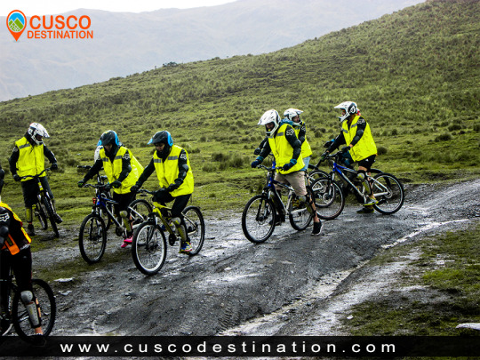
Our Inca Jungle Trail classic To Machu Picchu combines adventure sports such as mountain biking, rafting, zip line, hot spring and trekking for 4 days until you reach Machu Picchu....
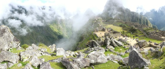
In the upper area close to the Skies, the Incas built one of their best-preserved cities, now recognized as one of the 7 wonders of the modern world. Many travelers and adventurers come....
According to the research, the coloration of the rainbow mountain is due to the composition of minerals that it has: the pink color is for the red clay, fangolitas and arilitas. The whitish, for the quartzose ...
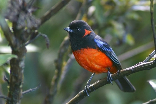
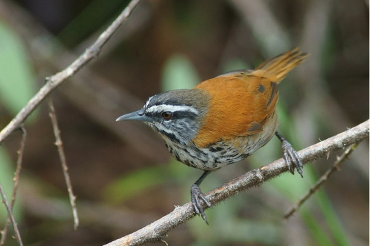
The Abra Malaga is a route that starts in the town of Ollantaytambo, Cusco and runs along the 28B Ollantaytambo - Quillabamba road through unique Andean ecosystems. This route contains two types of well-defined areas: El Abra (4,297 meters above sea level) and the lower zone (Carrizales 3,245 meters above sea level). The birds you can see are rare and highly sought after. The predominant ecosystem is the rain forest Montano Tropical or cloud forest in the Carrizales area, with low-rise tree forests covered by epiphytic plants and also some bamboo areas. In the Abra Málaga, at 4,200 meters high, we are in a tropical rainforest-Montano moor, with small Polylepis forests at the basin births.
History
The birdlife in this area of Peru
was studied since 1869 by Sclater and Salvin, Berlepsch and Stolzmann (1906).
In 1915 an expedition of the Geographical Society Machu Picchu is made, directed by Frank M. Chapman and George K. Cherrie (July 1-24, 1916), and by Harry L. Watkins (April 3-25, 1917).
From September 1974, June 1976, 1977 and 1978, October 1978 and August 1979, personnel from the Zoological Museum of Louisiana State University (LSU) visited the valley to conduct an inventory and increase knowledge of birds and small mammals. Three main camps were made along the Ollantaytambo-Quillabamba road through the Abra Málaga (3900 m), and a fourth was in Kiteni (450 m), after Quillabamba.
Starting from Ollantaytambo, the first place to visit is Las Peñas, located 15 Kms from the town. Named for having remains of Inca stone constructions in place. In the surroundings, between the bushes and at the edge of the road you can see: Cuzco Brush-finch, Chestnut-breasted Mountain-finch, Tyrian Metaltail, Shining Sunbeam, White-tufted Sunbeam, Puna Tapaculo, White-browed Conebill.
Another place of interest is the descent of the Abra, on the way to Quillabamba, where the good places are the Vegetation patches around the track, there you can see the Puna Thistletail, Unstreaked Tit-tyrant, Creamy-crested Spinetail, Diademed Tapaculo, Thrush- like Wren, Rufous-chested Tanager, Buff-breasted Mountain-tanager, Chestnut-bellied Mountain-tanager, Scarlet-bellied Mountain-tanager, White-bellied Hummingbird.
The Abra Málaga Thastayoc is the highest point of the route and is the safest and most accessible area to see the Royal Cinclodes. To do this you must follow the path that starts at the checkpoint, located at the highest point of the Abra. From there follow the path until you reach a Polylepis forest located at 4,150 meters high. You can also see the Stripe-headed Antpitta, Blue-mantled Thornbill, Shining Sunbeam, Puna Tapaculo, White-browed Tit-spinetail, Tawny Tit-Spinetail. The route for this forest is very rugged and long. It takes 2-3 hours to travel.
Weather
The weather is rainy between the months of November to April, and temperate with infrequent rains between the months of May to October. The temperature varies from -5 degrees in the Abra Málaga to 20 degrees in the Carrizales area.
Policies
Along the road it is not necessary to make any payment. To enter the Cinclodes route, it is necessary to pay an entrance fee, differentiated for Nationals and Foreigners. This payment is made at the checkpoint. Here you have bathrooms.
INFORMATION OF INCA JUNGLE
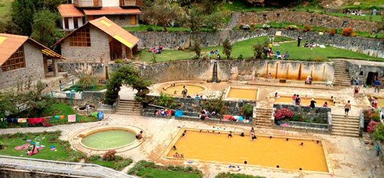
The people of Lima who live in Cusco have a typical crisis due to lack of the sea. Luckily we have the hot springs of Lares, which although it is neither beach nor sea, has enough water to kill the withdrawal syndrome or at least, shuffle it a few more weeks.
INFORMATION OF LARES TREK Lares is in the Valley of the same name, and it is reached by means of a road that departs from Calca in the Sacred Valley (located after Pisac). It is literally on the other side of the mountain range. I already went a couple of times: the first by car and the second on foot from Huarán as I told you in the post Stairway to Heaven.
What is special about Lares? WATER as a court, and best of all, warm to fight the cold of Cusco and calate a little like in San Bartolo or La Herradura. In the technical words of our Mincetur friends: “the temperature ranges between 36º and 44ºC, the medicinal mineral water outcrops have Calcium, Magnesium, Sodium, Potassium, Chlorides, Sulphates, Bicarbonates, Iron, Manganese, Zinc, Boron, Copper and dissolved solids. The waters have a yellowish coloration, here we find the presence of stalactites and stalacmites at the entrance of these baths ”.
We may not fully understand what a stalacmite is, but it turns out that these waters are good for treating rheumatic, traumatic (arthritis) fracture treatment, osteo joint pain, muscle aches, stomach diseases and more. For my part I assure you that a bath in Lares encourages your soul and leaves you ready for your return to the sea.
The entrance to Lares is 10 soles, general admission, only the people of Cusco pay 4 soles. If you want you can camp. It costs five soles per tent. I recommend it: so you can enjoy the baths all night and relax until you are tired of being happy. There are also lodgings, both in the town of Lares (2 kilometers) or near the bathrooms. Average, 25 soles per person. The buses from Calca to Lares cost 10 soles and take two hours to arrive.
In general, I suggest having two full days for Lares, staying one night. The first way, you need at least five hours to get to the bathrooms from Cusco (Cusco - Calca is like two hours more the trip to Lares). All that day you can spend floating, with intervals of walk, walk (there are interesting roads) and return to any of the four pools. You sleep well. The next day you finish off with a few more hours to cut it and you return to Cusco. You were not in the sea, but in the water, which is the mother of all things.
The Lares Valley is located between the eastern slopes of the Andes and the northern part of the Urubamba Mountain Range, it is a place with beautiful glacial lagoons and warm subtropical ravines, it also has a great variety of vegetation and wildlife. information of Lares Trek
It is surrounded by a mountain chain of the mountain range, where the snows of Verónica, Sawasiray, Pitusiray and Chicón are located. Small communities of Quechua-speaking farmers live here, who maintain their customs of grazing llamas and alpacas, growing tubers and producing tissues.
For all the above, this valley grants a great variety of tourist attractions. It is common for tourists to come to Lares to interact with local communities and learn more about their traditions, and it also gives the possibility of doing one of the best trekking routes in Cusco.
Location
It is located in the province of Calca, in the department of Cusco.
Climate and temperature
Between the months of May and October the area presents a sunny climate, with a temperature from 15 ° C to 21 ° C. From the months of November to April it is rainy season.
Altitude
It has a height of 3,170 masl.
How to get to Lares Valley
To get to Lares you can access by doing 2 routes. The first Cusco - Pisaq - Calca - Lares and the second Cusco - Chinchero - Urubamba - Calca - Lares. The road is in very good condition but it still takes time to reach the destination, it is advisable to hire the services of an agency to reach the Lares Valley.
Medical tourism is a type of tourism that is gradually acquiring a greater number of followers, and that has in the Peruvian territory an impressive range of resources to choose from, since if there is something that abounds in all regions of the country These are the sources that, in addition to relaxing and relieving the visitor from stress, are capable of relieving any suffering they may have.
The Thermal Baths of Lares, are one of these thermomedical resources that the traveler will be able to enjoy when he goes to a region like Cusco. These thermal baths, as the name suggests, are located in the district of Lares, which is located in the province of Calca.
Lares Thermal Baths are made up of a group of four swimming pools. These are fed by waters that are tempered to different degrees. The temperature of the thermal pools of Lares fluctuate between 36 ° C and 44 ° C and the pools have dimensions between 17 m2 and 120 m2, with depths that do not exceed one and a half meters, making it suitable for a greater number of visitors.
These thermal baths are visited by the properties that present their waters, which in addition to offering comfort and stress relief are able to relieve certain conditions. This is achieved thanks to the fact that the waters of these Thermal Baths of Lares are fed by minerals such as sodium, potassium, magnesium, calcium, iron, zinc, among many others, which together allow us to fight diseases such as arthritis , osteoporosis, in addition to contributing to the rehabilitation of broken bones, combating muscle, stomach problems, among many others.
To get to the Lares Thermal Baths, the visitor has to travel from the city of Cusco to Calca, this tour can take approximately an hour and a half, and can be done on a public bus, this usually charges approximately S / 4.00 per passenger. Already in Calca a combi is taken that in two hours leaves it in the district of Lares, the cost of this vehicle does not usually exceed S / 10.00. From Lares you should only continue on foot for approximately 1 km to the thermal baths. This last tour can be completed in just fifteen minutes, depending on the physical conditions of the visitor, if you want you can also rent a taxi.
Those who visit the Thermal Baths of Lares should keep in mind that the only tourist infrastructure that exists in the place is the hot springs, and that the closest services can only be found in the city of Calca and Lares, despite these inconveniences, the environment The Lares Thermal Baths are more than suitable for camping, so the traveler will have the opportunity to enjoy the benefits of these waters for a longer time.
In order to access the Lares Thermal Baths, the visitor has to make a payment whose cost ranges between S / 3.00 and S / 5.00. Visits to these thermal baths can be made at any time of the day. LARES TREK INFORMATION
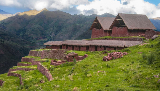
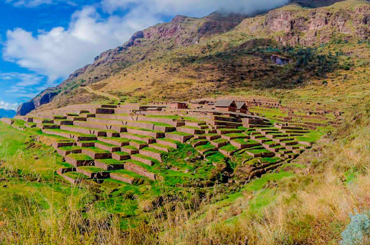
Long grouping of terraces with walls as retaining walls, which leave terraces suitable for agriculture.
Three-story building, the first two are two almost regular polyhedra and the third is adobe. The enclosure is rectangular and of excellent quality.
Foundations and remains of two identical buildings, inside and arranged next to it, in succession. A long adobe building, rectangular, on a prominent platform, a building that has many doors to the valley.
Many smaller enclosures dispersed and in poor condition.
An Inca road nearby oriented straight towards Cusco.
Some small loose enclosures, such as outposts or guard posts, on the edge of the cliff, with visual control over the wide valley.
Nail stones or false stone beams, belonging to the mojinete of the buildings.
How to get to Huchuy Qosqo?
The routes to get to Huchuy Qosqo Trek are many, among which we have:
Walk through the town of Lamay-Calca.
Walk through the town of Cuper Alto-Chinchero-Urubamba
Walk through the ruins of Tambomachay (the busiest)
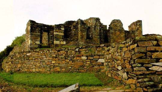
Huch’uy Qosqo (Quechua: “Little Cuzco” also called Yuchuy Cuzco) is an archeological site 50 km north of Cusco, in Peru. It is located at an altitude of 3,600 meters, above the city of Lamay, in the district of Calca, province of Calca, in the Sacred Valley of the Incas.
The site was named in the twentieth century; He had previously been known as Kakya Qawani. Pedro de Cieza de León, in his Second Chronicle of Peru, said that the palaces were built by Viracocha, the eighth Inca ruler. Among a large number of buildings, some of stone, some of adobe, is a Kallanka (large hall) 40 m long. The water supply is an Inca built irrigation canal, filled with stones of about 800 meters.
Huchuy Qosqo was probably established as a royal estate by the Inca Emperor Viracocha around 1420 CE
The Spanish took control of Kakya Qawani in the year 1500, after the Inca Manco Revolution (approx. 1540) and the site is used as a farm. Villagers built several small reservoirs for irrigation. During their time in Huchuy Quosqo, the Spaniards demolished some other Inca structures to build the largest reservoir seen today.
Below the main site of Huch’uy Qusqu is the recently restored storehouse for meat and crops such as corn, potatoes, quinoa and dried beans. In this two-story structure, you can see the historic refrigeration storage system known as ‘conjeras’.
The settlement in the archeological ruin in Huchuy Qusqo dates back to between 1000 and 1400 CE. In the early 1400s, according to the Spanish chronicler Pedro Cieza de León, it became a real property of the semi-mythical Viracocha (c. 1410-1438), the eighth Inca ruler.
The Inca Empire did not impose the income or production of its citizens as a common practice, but rather controlled the land and labor. Thus, the Inca leaders acquired great real properties to increase their power and wealth and that of their descendants who inherited the properties. The royal properties also served as elegant rural palaces and sometimes fortresses to defend themselves against their rivals for power. Thus, the name Huchuy Qosqo, "Little Cusco", for a real property or government center modeled in the Inca capital.
To build, operate and maintain their assets, Viracocha and its descendants required a large number of workers. The citizens of the Inca empire were obliged, under the mit’a system, to contribute labor to the Empire, instead of paying taxes on their wealth or production. Mit'a impressed labor was probably found among nearby ethnic groups, although specialists and artisans could be imported.
Another Inca policy, that of mitma, was probably used to collect labor for the royal heritage. The mitmaqkuna were entire families or ethnic groups that moved to new lands in the empire or settled in enclaves among the first inhabitants of an area. The purpose was to widely distribute the different ethnic groups, thus separating potential troublemakers and reducing the possibility of organized resistance to the Incas. The mitmaqkuna were discouraged from mixing with local ethnic groups. A third source of work for the farm was the Yanakunas, the permanent servants of the Incas. The Yanakuna often reached high positions in the Empire, and as the mitma were ruled directly by the Incas. Still a fourth source of work for the royal states was aqllakuna, abducted women who lived together and produced textiles, an important source of Inca wealth, and chicha, the fermented drink consumed at parties. The Allakuna used to marry men honored for their service to the Empire.
These four sources provided the work and experience for the management of a real estate that could control thousands of acres of agricultural and grazing land, mines, textile factories and other resources and employ thousands of people. The sixteenth-century Spanish sources identify more than 40 ethnic groups found in an area of the Sacred Valley, an indication of the degree of resettlement and disruption of the population undertaken by the Incas during their reign.
Among a large number of buildings, some of stone, some of adobe, are a Kallanka (large hall), 40 m long. The water supply to the site is an irrigation canal built by the Incas, lined with stones for about 800 m.
Inca wall and agricultural terrace (anden). The Spanish took control of Huchuy Qosqo in the 1500s, after the Inca Revolution of Manco (approximately 1540) and used the site as a farm. The Incas had built several small reservoirs for irrigation. During their stay in Huchuy Qosqo, the Spanish demolished some other Inca structures to build the largest reservoir seen today.
Below the main site of Huchuy Qosqo are the recently restored qolqas stores for dried meats and crops such as corn, potatoes, quinoa and beans. In this two-story structure, you can see the historic refrigeration storage system known as "shells."
INFORMATION OF HUCHUY QOSQO TREK
This site is inaccessible by a public road and can only be accessed by a physically strenuous walk or on horseback. The two main access points on foot are from Lamay: 3 hours to a series of sharp curves, or from Tauca, Peru, about 4 to 6 hours on foot. The first third of the walk steadily increases up to a step at 4400 m, then mostly Descent, and visiting other ruins. The 2-day route from Tauca to Lamay is described in "Exploring Cusco" by Peter Frost. Several tour groups also take two-day walks or horse riding excursions to Huchuy Qosqo.
KNOW MORE -This route starts in Ccorao, where it deviates to Patabamba and then to Quenqo, where the seven-hour hike that ends in Lamay, in the Sacred Valley begins.
-The name of Huchuy Qosqo was put in 1930 by the intellectual from Cusco, José Gabriel Cosio; but the real name is Qacya Qawarina (‘where is the thunder’).
This complex is the most important archaeological center in the Urubamba Valley, after Ollantaytambo and Pisac. The ruins are impressive, although the conservation of the site is inferior to that of Ollantaytambo or Pisac, because they are older.
But unlike the places mentioned above Huchuy Qosqo has a peculiar architecture: the buildings have been built on polished stone bases of fine finish, with clay plaster (they are the best preserved parts) and the highest floors are made of adobe.
There is a kallanka (rectangular enclosure that could measure up to 70 meters long and that were important state centers where Inca officials were staying) of at least 40 to 50 meters long. Also a remarkable building with two stone floors and an adobe upper one. There are also large terraces, a very large square and a large Inca gate through which a very well preserved road leads from Tambomachay.
INFORMATION OF HUCHUY QOSQO TREK
The Hispanic chronicles indicate that Huchuy Qosqo (probably a site known in Inca times as Caquia Jaquijahuana) was the work and favorite place of the Inca Wiracocha. To this, Maria Rostworoski adds, in her work "History of Tahuantinsuyo", that this sovereign strengthened the conquest over the villages of the Urubamba Valley and that he chose as his successor his son Inca Urco who, dizzy from power and vice, He proved to be totally unable to govern. The Inca royalty was very obfuscated with this election and tried to conspire to impose another son of Wiracocha, Prince Cusi Yupanqui. Social unrest and tension increased every day and to make everything worse, the darkest night fell over Cuzco: the Chancas reached the gates of the capital and were willing to destroy it. It is the year of 1438. Wiracocha leaves the city to his fate and, accompanied by his son Inca Urco, takes refuge in its palaces in the Urubamba Valley, among which was Huchuy Qosqo.
After the Hispanic conquest, Gonzalo Pizarro found here the mummy that supposedly belonged to the Inca Wiracocha and ordered it burned. The descendants of the Inca kept the ashes in a jar that many years later the chronicler Polo de Ondegardo would discover.
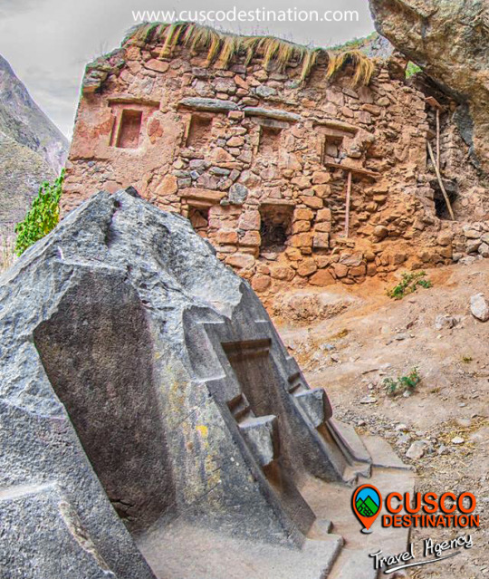
This place was dedicated to the extraction and carving of the stones that were used for the construction of Ollantaytambo and many surrounding precincts. This place is located about 14 km from the Inca town of Ollantaytambo and has three groups of quarries: Molle Pucro, Sirkusirkuyoc (it was the largest of the three), shows the evidence of having been fully operational when the Spanish arrived in this area . And finally Cacchicata or Kantirayoq, where another type of extraction of minerals and precious stones was practiced. Visitors can observe the great work done at the time of moving the giant stones to build Ollantaytambo enclosures. We can find the stones called "Tired Stones" that were on their way to Ollantaytambo and in some parts of the city. Cachicata or Inca quarry is one of the old quarries used by the pre Inca and Inca civilizations to build the vast complexes of Ollantaytambo. It was a source of large amounts of pink granite. Cachicata quarries are 14 km from Ollantaytambo. The view of Ollantaytambo from the quarries is spectacular and during the walk you can see many large stones that remained in the middle of their long trip to the village. It was also a commercial route for the Incas. Cachicata is a small and remote town that can benefit from the occasional visit of tourists.
INFORMATION OF CACHICATA TREK
The Hike to Cachicata is a great alternative to the famous Inca Trail hike. This road was built by the Incas and used for hundreds of years to access local communities and transport goods. This trail is not as well known as the Classic Inca Trail, so much less crowds and a more serene trekking experience in Peru are expected. This hiking adventure not only visits Peru's cultural past, but also explores modern Inca communities and customs. The trail takes us through isolated waterfalls, ancient terraces and exotic wildlife, while offering fantastic views of the Sacred Valley and its snowy mountains. Visit with local families and explore an active quarry. Each step brings a new look to the Inca culture.
The Walk towards the enigmatic Cachiccata Quarries will take you to know one of the little known places where the stones were extracted for the construction of the cultivation terraces, temples and the entire archaeological complex of Ollantaytambo.
The adventure will take you to one of the most spectacular routes, full of beautiful and spectacular views of the sacred valley and the mystical city of Ollantaytambo, this is one of the beauties that hides the tour to the Sacred Valley in all its splendor. This place was dedicated to the carving and extraction of the stones that were used for the construction of Ollantaytambo and many surrounding precincts.
Location:
It is located 9 km from the Ollantaytambo district, "The Living Inca City" in the province of Urubamba, Cusco region.
How to get?
On your own: The first thing is to go from the city of Cusco in a car or bus to Ollantaytambo (approximately 2 hours), once in the square of Ollantaytambo we will begin the walk: from the Plaza de Armas de Ollantaytambo take the Main Street towards Cusco, until arriving to the track, there instead of turning left where the stone street ends, continue straight on the path until you reach the Inca bridge. Cross it and walk to the right. After a 15-20 minute walk uphill, take a slope to the left at the fork, marked by a rock painted with "Las Canteras". In 20 minutes, agricultural platforms and foundations of old buildings will come into view. Follow the right trail and ignore other paths that cross. The trail will merge with a larger path. Continue through the mountain slope on this main road to the quarry, which is indicated by small stone foundations above boulders. (Minutes before reaching the quarry, the path passes through an irrigation canal, the last chance to cool off).
The first quarry is 2 hours after leaving the Plaza de Armas. Just after passing this quarry, continue on a smaller path to the left. Follow a series of zigzags to the hillside, for 45 minutes or an hour. Shortly after, the second much larger quarry will be visible on the left. The small fields on the right are a great place to camp. As a reference, a rock in the middle of the quarry painted with "National Institute of Culture". Hiring a tour with a tour operator: Definitely the safest and recommended option would be this, because they deal with the transfer to this archeological area better and solve any inconvenience that may exist, are responsible for transport, guide, refreshment, etc. What attractions do you have?
It has three groups of quarries:
Molle Pucro, the most accessible and popular quarry.
Sirkusirkuyoc (it was the largest of the three), shows evidence of having been in full operation when the Spaniards entered this area.
Kantirayoq or Cacchicata, where another type of extraction of minerals and precious stones was practiced.
We will also visit the slopes of Cachiccata, the pyramid of Paqariqtampu and the imposing surrounding snow-capped mountains.
We can find the so-called "Tired Stones" that stayed during the trip to Ollantaytambo and in some parts of the town.
In the same way we can observe the great work they did at the time of moving the gigantic stones to build the Ollantaytambo enclosures.
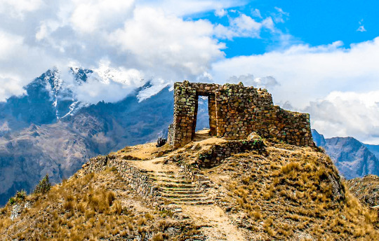
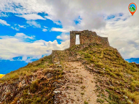
This place is also known by the Intipunku (cover of the Sun), considered as a Sacred place of Spiritual retreat since ancient times, where you can feel the energy of the Apus (mountain spirits) and recharge positive energies on the heights of the Sacred Valley.
Recommendations:
Be sure to eat and be well fed; You can bring snacks such as energy bars, nuts, chocolatillos. Drink water: Stay hydrated during the walk is very important. Take Coca Mate or chew Coca Leaves will help reduce and prevent altitude sickness. Sunscreen: Be sure to apply a minimum sunscreen every 02 hours and wear sunglasses accompanied by a hat or hat. Rain protection: There is always a chance of rain so be sure to wear rain clothes. Wear warm and waterproof jackets and light clothes for the sun.
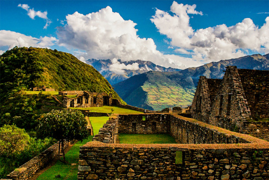
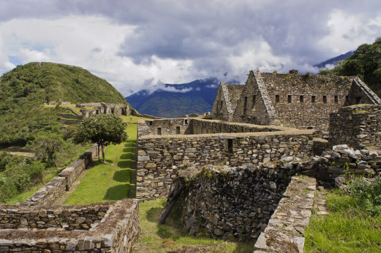
The Choquequirao fortress is located in the Vilcabamba area, where the Incas of the Manco dynasty resisted the Spanish conquerors for 36 years (1536 - 1572), who never managed to expel them from it.
The construction of Choquequirao is the work of the successors of the Inca Pachacútec, Túpac Inca Yupanqui (1471 - 1493) and Huayna Cápac (1493 - 1527). In the place, domestic and ceremonial ceramics of the classic Cuzco style were used, as well as others, typical of the population that moved to build and populate the site permanently, probably farmers experienced in building and exploiting agricultural platforms in eyebrow areas jungle.
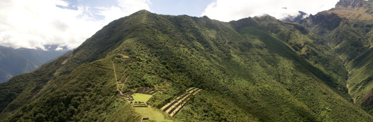
Approximately 40% of the Inca ceremonial center of Choquequirao is free of vegetation and restoration and enhancement work is currently being carried out. The remaining area is formed by a complex system of platforms built on very steep slopes. A short time ago, an impressive 180-platform staircase has been located that descending from one of the flanks of the ceremonial center reaches the river, where it is possible to swim.
Choquequirao was possibly one of the entry control points to the Vilcabamba region, and as such an administrative nucleus with political, social and economic functions. In its urban conception it followed the symbolic patterns of the imperial capital with places of worship dedicated to the Sun, ancestors, land, water and other divinities, royal residences, houses of administrators and artisans, warehouses, large dormitory buildings or Kallancas and agricultural platforms of the Inca and the town. The ceremonial area extends over 700 meters, with a level difference of up to 65 meters between the main square and the highest parts. The complex consists of nine stone architectural groups and a system of 180 platforms, apart from the areas of residential, administrative, craftsman, irrigation system, among other buildings built on a stone base.
The sectors that are defined by the topography of the place had different functions and communicated through pedestrian access to the main square. You can see a complex hydraulic system probably designed for domestic, ceremonial and agricultural use.
Given the geographical location of Choquequirao, compared to other complexes of the same period, it seems that it had the function of being an Inca enclave towards the hot valleys of the Apurimac River. Its inhabitants dedicated to intensive agriculture and performed ceremonies where water was an important element of worship. In addition, it was a storage place for various products from other areas, as well as a connection between the valleys of Apurimac, Vilcabamba and Vilcanota.
Choquequirao is located on the border of the department of Apurímac and Cuzco, the archaeological site of Choquequirao was not built to be a place that is accessed as if in passing, and now reaching it demands two days of disciplined march, largely offset by beauty of the landscape that accompanies the walker from his first steps.
The journey begins in Cachora (2,800 m.a.s.l.), a small town in the department of Apurimac which is reached, having departed from Cuzco, after four hours of good road (145 km asphalted and 10 km affirmed). It is there where the mule muleteers are contacted, who also act as guides. A local family offers lodging and the only phone in the town.
Walk to Choquequirao Currently the trek to Choquequirao (trekking) has become one of the best alternatives to the famous Inca Trail to Machu Picchu, with which it competes in scenic beauty and adventure. The traditional route is Cachora, Coca Masana, Rosalina Beach, Choquequirao, Raqaypata, Chikisca, Cachora. There are also walks that link Machu Picchu with Choquequirao. Normally the adventure begins in the city of Cuzco, on a road trip of 93 km (3h 30 'by car) to the town of Cachora at 2,300 meters above sea level, and from there a 30-kilometer walk starts in 4 or 5 days, with a total of 60 kilometers, crossing areas of abundant and varied vegetation and fauna from the high Andean zone to the jungle, crossing the Apurimac river canyon.
Tour operators offer the service of guides and porters and all the logistics required for the walk. More information of Choquequirao Trek
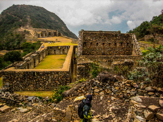
Choquequirao has only been excavated 30%. Despite this, it already has several very important Inca constructions:
Main square: the main square or Huaqaypata divided the site in two. It is a two-story stone construction. Next to him, there are other buildings connected to each other.
Colcas - Typical buildings of the main Inca centers. In Choquequirao, these platforms have internal subdivisions. The purpose of these deposits was to store products for food, clothing and others.
Platforms: Choquequirao has a significant number of platforms for cultivation. In the western sector there are 22 flame-shaped engravings arranged on 15 platforms. These figures are known as the ‘Flames of the Sun’.
Housing: in the highest part of Choquequirao, there are up to 5 buildings whose purpose was probably housing for the priests of the enclosure. It is believed that this Inca site was an important ceremonial center.
Inca Cemetery - Also known as the ‘Triunfal Wall’. 17 funeral bullets and a water gutter called "The House of the Water Fall" were found.
Kallankas: these rectangular buildings had multiple functions, such as workshop, administrative center, meeting space, etc. In Choquequirao there are 2 Kallankas on whose walls there were canals that supplied water.
Ushnu: This oval platform construction is located on top of a hill. Due to the surrounding wall and the privileged view of the snow-capped mountains, the river and the whole enclosure; It is believed that it had a religious purpose.
The lost city of the Incas of Choquequirao was probably built in the fifteenth century, along with the city of Machu Picchu, during the administration of the Inca Pachacútec. However, this statement is contradicted by other historians who claim that its construction was later than Pachacútec, during the governments of Túpac Yupanqui or Huayna Cápac. Choquequirao Trek Information
In the Inca era, Choquequirao was a very important cultural and religious center that served as a commercial enclave and waypoint to Vilcabamba and Machu Picchu.
During the Inca resistance to the Spanish invasion, Choquequirao was one of the last bastions of resistance and Inca refuge. But, at the fall of the great Inca culture, the Inca people of Choquequirao passed to the forgotten one, and the immeasurable jungle was responsible for hiding it for many centuries.
Just in the early 1800s, the first explorers began to explore the lost city of Choquequirao.
But, it was not until the end of the 1990s that intensive studies began and the restoration plan began.
Currently, of the 1810 hectares comprising the Inca Llaque of Choquequirao, only 30% have been unearthed and put into operation as a tourist area. While 70% of the ruins still lie under the frond of the jungle eyebrow.
Structure
Unlike Machu Picchu, the Archaeological Ensemble of Choquequirao is a dispersed and varied settlement.
Its architectural structure was built with edged stones and mud mortar, and is composed of:
A ceremonial platform (Ushno).
An upper square (Hanan) and a lower square (Hurin).
Temples
Niches
Housing of the priests.
Deposits and barns (Qolqas).
Ditch network.
And a platform system.
Choquequirao sectors
Choquequirao is organized in 12 separate sectors (zones), whose paths converge to a large main square.
Sector I. Located in the highest part, in the Hanan area. It includes an upper main square, buildings and an aqueduct that descends through successive stone fountains (phacchas).
Sector II Located in the Hanan area, below sector I. It includes the Warehouses and warehouses (qolqas) and the “Giant Stairs” stairs of Bingham.
Sector III It is the central nucleus of the citadel. It is located in the upper (hanan) and lower (hurin) sectors. It is made up of the main square or Hauqaypata, some annexed buildings of one and two levels (houses of the rulers and Kallankas).
Sector IV Located in the Hurin or South zone, it is a main building composed of five covers that were probably used for ceremonial uses. In this place is the Temple of the triumphal wall and the sacred pens.
Sector V (Ushnu). Located on top of a hill. It presents a ceremonial oval platform that is surrounded by a small wall. From this place you can see much of the archaeological park of Choquequirao, the mountain range of the Vilcanota Range and the great Apurimac canyon.
Sector VI (Wasi Cancha). It is located south of the ushnu, in the lower part. Also known as temple and housing of priests.
Sector VII. Formed by cultivation platforms on the east side (monumental platforms or sacred platforms), which stand out for hosting wide and wide platforms.
Sector VIII. Made up of 80 platforms, divided into plots and water channels that descend from the main square. Here are the famous "platforms of the Flames of the Sun"
Sector IX. Constituted by popular or family homes. It is better known as Pikiwasi.
Sector X (Paraqtepata). Formed by 18 cultivation platforms and irrigation canals parallel to the stairs.
Sector XI. Located in the area called Phaqchayoq, on the right bank of the Ch’unchumayo stream. It is composed of 80 wide platforms.
Sector XII In this sector are the cultivation platforms. It is made up of 57 platforms with permanent irrigation.
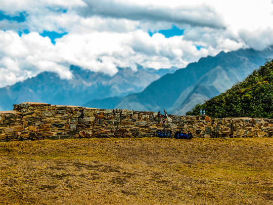
Spectacular and distant, lonely and forgotten, Choquequirao (3,085 masl) is ruled on the top of an almost impregnable mountain in the province of La Convencion, department of Cusco, reason that made it for more than 40 years the last bastion of resistance of The children of the Sun, who sought refuge in their stone walls, after the defeat of Manco Inca, the rebel Inca, will visit palaces, two-level temples, fountain systems, canals, aqueducts, and their admirable "upholstered" profuse platform Vegetation, a place worth the effort. The fatigue yields to the magnificence of Choquequirao.
More Information of Choquequirao Trek
The geographical location is northeast of Cusco between the rivers of Apurimac, Urubamba and the majestic Salkantay with a maximum height of 6,271msnm and a minimum of 2,575 meters above sea level. The Vilcabamba range offers the unique opportunity of a fascinating hike between an environment of glaciers, green mountains, bears, condors, tarantulas, etc. This cloud forest region served as a refuge and natural fortress for the 16th Inca resistance movement of the 16th century, which sought to regain control of the Tahuantinsuyo from Spanish invaders. The customs and clothes typical of local people reflect a mixture of cultures. Its tongue and textiles with Inca and Pre-Inca ornaments, give clear evidence of the influence of the Quechuas. Vilcabamba is also the region where there is a concentration of Pre-Columbian archaeological treasures, including Choquequirao and the famous citadel of Machu Picchu. There is a network of operation of the Inca roads that connects the pampas of Vitcos, Rosas pata and Espiritu Pampa.
This place was dedicated to the carving and extraction of the stones that were used for the construction of Ollantaytambo and many surrounding precincts. This place is nine kilometers from the Inca town of Ollantaytambo and has three groups of quarries:
Molle Pucro, Sirkusirkuyoc (it was the largest of the three), shows evidence of having been in full operation when the Spanish entered this area. And finally Kantirayoq or Cacchicata, where another type of extraction of minerals and precious stones was practiced. The visitor will be able to observe the great work done when moving the gigantic stones to build the Ollantaytambo enclosures. We can find the so-called "Tired Stones" that stayed during the trip to Ollantaytambo and in some parts of the town.
The Walk to the Cachicata Quarries is located in the Ollantaytambo district, the living Inca city, this wonderful walk will take you to know one of the little known places where the stones were extracted for the construction of the cultivation terraces, temples and The entire archaeological complex of Ollantaytambo. We venture into a route full of beautiful and spectacular views of the sacred valley and the mystical city of Ollantaytambo.
We will take you to know the beauties that the sacred valley hides in all its splendor. We will visit the slopes of Cachiccata, the Paqariqtampu pyramid and the imposing snowfall. It will be an unforgettable experience with the best service provided by our professionals, you will be delighted with such beauty that nature offers us. Those who decide to undertake this cultural journey will return full of the ancestral spirit of the Incas and with a little piece of the Andes in their hearts.
The Walk towards the enigmatic Cachiccata Quarries will take you to know one of the little known places where the stones were extracted for the construction of the cultivation terraces, temples and the entire archaeological complex of Ollantaytambo.
The adventure will take you to one of the most spectacular routes, full of beautiful and spectacular views of the sacred valley and the mystical city of Ollantaytambo, this is one of the beauties that hides the tour to the Sacred Valley in all its splendor. This place was dedicated to the carving and extraction of the stones that were used for the construction of Ollantaytambo and many surrounding precincts.
Location:
It is located 9 km from the Ollantaytambo district, "The Living Inca City" in the province of Urubamba, Cusco region.
How to get?
On your own: The first thing is to go from the city of Cusco in a car or bus to Ollantaytambo (approximately 2 hours), once in the square of Ollantaytambo we will begin the walk: from the Plaza de Armas de Ollantaytambo take the Main Street towards Cusco, until arriving to the track, there instead of turning left where the stone street ends, continue straight on the path until you reach the Inca bridge. Cross it and walk to the right. After a 15-20 minute walk uphill, take a slope to the left at the fork, marked by a rock painted with "Las Canteras". In 20 minutes, agricultural platforms and foundations of old buildings will come into view. Follow the right trail and ignore other paths that cross. The trail will merge with a larger path. Continue through the mountain slope on this main road to the Lowe quarry, which is indicated by small stone foundations above boulders. (Minutes before reaching the quarry, the path passes through an irrigation canal, the last chance to cool off).
The first quarry is 2 hours after leaving the Plaza de Armas. Just after passing this quarry, continue on a smaller path to the left. Follow a series of zigzags to the hillside, for 45 minutes or an hour. Shortly after, the second much larger quarry will be visible on the left. The small fields on the right are a great place to camp. As a reference, a rock in the middle of the quarry painted with "National Institute of Culture".
Hiring a tour with a tour operator:
Definitely the safest and recommended option would be this, because they deal with the transfer to this archeological area better and resolve any inconvenience that may exist, are responsible for transportation, guidance, refreshment, etc.
What attractions do you have?
It has three groups of quarries:
Molle Pucro, the most accessible and popular quarry.
Sirkusirkuyoc (it was the largest of the three), shows evidence of having been in full operation when the Spaniards entered this area.
Kantirayoq or Cacchicata, where another type of extraction of minerals and precious stones was practiced.
We will also visit the slopes of Cachiccata, the pyramid of Paqariqtampu and the imposing surrounding snow-capped mountains.
We can find the so-called "Tired Stones" that stayed during the trip to Ollantaytambo and in some parts of the town.
In the same way we can observe the great work they did at the time of moving the gigantic stones to build the Ollantaytambo enclosures.
This place is also known by the Intipunku (cover of the Sun), considered as a Sacred place of Spiritual retreat since ancient times, where you can feel the energy of the Apus (mountain spirits) and recharge positive energies on the heights of the Sacred Valley.
Recommendations:
Be sure to eat and be well fed; You can bring snacks such as energy bars, nuts, chocolatillos.
Drink water: Stay hydrated during the walk is very important.
Take Coca Mate or chew Coca Leaves will help reduce and prevent altitude sickness.
Sunscreen: Be sure to apply a minimum sunscreen every 02 hours and wear sunglasses accompanied by a hat or hat.
Rain protection: There is always a chance of rain so be sure to wear rain clothes.
Wear warm and waterproof jackets and light clothes for the sun.
CHOQUEQUIRAO es un lugar tan maravilloso como Machu Picchu; menos conocido, más inexplorado. Virgen y libre de la abundante visita turística. Un Machu Picchu para llegar como mochilero, con largas caminatas independientes y acampadas en la ruta. Choquequirao es también conocida como la hermana sagrada de Machu Picchu. Se trata pues de un gran complejo arqueológico con edificios y terrazas, testimonio de los Incas conquistando las alturas de las montañas.
En esta guía aprenderás cómo llegar por tu cuenta a este santuario. Aprovecha los recursos de Cusco destination para descubrir una de las ruinas más impresionantes de Latinoamérica.
Antes debes saber un par de cosas:
¿Por qué si es tan increíble va tan poca gente o se sabe poco de él?
A diferencia de Machu Picchu a donde se puede llegar con trenes y ascender en buses, Choquequirao es un destino al que se llega a través de un intenso sacrificio y esfuerzo. Son caminatas duras que implican bajadas y desniveles con poco oxígeno. La manera de llegar es caminando mucho y acampando. Posiblemente tu abastecimiento de agua no sea suficiente, pases frío en las alturas o bien te quemes caminando bajo el intenso sol andino. El viaje completo puede hacerse entre 4 y 5 días salvo que quieras visitar algunos pueblos aledaños o hacerlo rápidamente.
¿Cuánto se camina hasta Choquequirao?
Desde el poblado de Cachora hasta Choquequirao se caminan alrededor de 31 kilómetros sin incluir el recorrido por las ruinas. De regreso sería la misma distancia (62 km en total). Una gran parte del recorrido implica la bajada de una gran montaña mientras que la otra mitad es en una subida.
¿Aqué altura está Choquequirao?
La ciudadela se encuentra a 3,035 m.s.n.m y en el punto más bajo de la caminata estarás a 1,461 m.s.n.m. El clima es similar al de Cusco por lo que es recomendable acondicionarte a las alturas antes de la caminata.