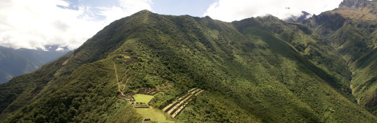
You can visit the architectural complex Choquequirao is situated in Vilcabamba at 3100 meters, considered the last Inka refuge and place of resistance from the invaders, when doing ....
Our Inca Jungle Trail classic To Machu Picchu combines adventure sports such as mountain biking, rafting, zip line, hot spring and trekking for 4 days until you reach Machu Picchu....
In the upper area close to the Skies, the Incas built one of their best-preserved cities, now recognized as one of the 7 wonders of the modern world. Many travelers and adventurers come....
According to the research, the coloration of the rainbow mountain is due to the composition of minerals that it has: the pink color is for the red clay, fangolitas and arilitas. The whitish, for the quartzose ...
Showing posts with label choquequirao information. Show all posts
Showing posts with label choquequirao information. Show all posts
Sectors of Choquequirao
In sector I, the sector of the plaza and temple, hanan area, located to the north and which is the highest part, there are five floor buildings, located on terraces of different levels. It is possible that they served as the residence of the priests. Higher up, there is another smaller plaza where two warehouse buildings (qolqas) and three other long residential buildings are located.
(kallankas). A wall with a main channel of water collected from the Ch’unchumayo stream also enters here, supplying the archaeological site and descending, like a spinal column, organizing the arrangement of the buildings.
In sector II, hanan zone, there are the deposits or qolqampatas divided into warehouses with internal subdivisions with quincha partitions; in another space, within this subsector, there are small ceremonial platforms (16 platforms), crossed by an alternate channel that takes advantage of the waters of the main channel. CHOQUEQUIRAO TREK INFORMATION.
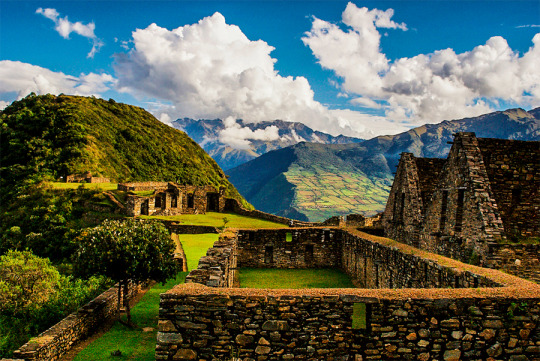
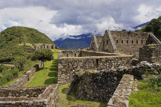
Sector III, which appears to be the main square or Hauqaypata, is located between the upper (hanan) and lower (hurin) sectors, on the filling of a platform. On the extreme sides of this square there are buildings with one and two levels. In the north there is a kallanka (building) for ceremonial use — Sunturwasi — with low niches (kind of chapels); To the east are two-story buildings with walls that support gabled roofs. They have two facades, one for entering the main plaza and the other that leads to a patio with side accesses. Access to these buildings is through double jamb covers (a double frame). These buildings are separated by a corridor, which highlights the largest building (kallanka) in the city that goes to the side of the backyard and that leaves through a wall to the south side, which is where the platforms in the north sector are located. of the city or llacta.
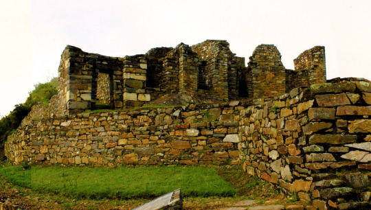
Sector IV, located in the Hurin or south zone, is a main construction made up of five covers called by Sartiges "triumphal wall" and by Samanez and Zapata "wall of offerings to the ancestors". The other four, probably, were for ceremonial use and would correspond to an open temple. Behind these covers is a field, where you enter a second level, which is above the covers.
Sector V is the ushnu: a hill cut at its top that forms a ceremonial oval platform and surrounded by a small wall as a fence, which is entered by an entrance that first rises by steps and from where you can see the main square and hanan site. From this place the snow-capped mountains and the Apurímac river are visible.
Sector VI is the Wasi Cancha, located south of the ushnu in the lower part; It is also known as a temple and home of priests. A space of four platforms with zigzag walls is observed, which was used as a ceremonial space. In the first wall it is finished off with a source for water, and the other platforms are accessed with stairs. Below this area of worship you can see a field or space with two enclosures of one and a half floors enclosed by a perimeter wall; from here you can see a good part of the Apurímac river canyon.
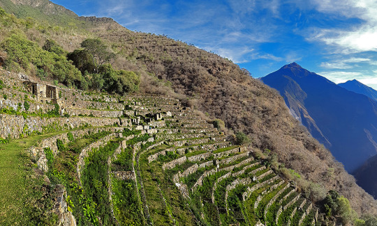
Sector VII belongs to the cultivation platforms on the east side. It stands out from the rest, for being wide and wide platforms. It can be entered through walkways from the main square.
The discovery was made in September 2004 within the framework of the «Cadastre and Delimitation (...) Sector VIII is an area of cultivation platforms, located on the west side, with eighty platforms, divided into plots and water channels that descend from the main square. Here were the famous "Llamas del Sol"
The ceramic remains show a multi-ethnic presence of the llacta (even though there has been int (...) Sector IX is made up of popular houses, also called Pikiwasi, and is where one of the water channels ends. The houses seem to have been for collective and family use, built on artificial platforms, rectangular, square and circular in design, communicating by means of stairs and narrow passageways.
Sector X is made up of the cultivation platforms, the Paraqtepata, made up of 18 platforms and irrigation channels parallel to the stairs. Sector XI also has cultivation platforms, the Phaqchayoq, made up of 80 wide platforms, the largest of the entire complex and located on the right bank of the Ch’unchumayo stream. There are also small quadrilateral enclosures in the middle of the plots with two-level enclosures, both for ceremonial use and for housing, with three sources for water and irrigation channels. Sector XII presents cultivation platforms three hours away from Hanan Square, and is made up of 57 platforms with permanent irrigation. In the upper part there are buildings for ceremonial use that occupy the entire width of the platform, a spring pool, a semicircular enclosure where ceramic remains, stone tools and bone remains were found.
MORE INFORMATION OF CHOQUEQUIRAO TREK
The Choquequirao fortress is located in the Vilcabamba area, where the Incas of the Manco dynasty resisted the Spanish conquerors for 36 years (1536 - 1572), who never managed to expel them from it.
The construction of Choquequirao is the work of the successors of the Inca Pachacútec, Túpac Inca Yupanqui (1471 - 1493) and Huayna Cápac (1493 - 1527). In the place, domestic and ceremonial ceramics of the classic Cuzco style were used, as well as others, typical of the population that moved to build and populate the site permanently, probably farmers experienced in building and exploiting agricultural platforms in eyebrow areas jungle.
Approximately 40% of the Inca ceremonial center of Choquequirao is free of vegetation and restoration and enhancement work is currently being carried out. The remaining area is formed by a complex system of platforms built on very steep slopes. A short time ago, an impressive 180-platform staircase has been located that descending from one of the flanks of the ceremonial center reaches the river, where it is possible to swim.
Choquequirao was possibly one of the entry control points to the Vilcabamba region, and as such an administrative nucleus with political, social and economic functions. In its urban conception it followed the symbolic patterns of the imperial capital with places of worship dedicated to the Sun, ancestors, land, water and other divinities, royal residences, houses of administrators and artisans, warehouses, large dormitory buildings or Kallancas and agricultural platforms of the Inca and the town. The ceremonial area extends over 700 meters, with a level difference of up to 65 meters between the main square and the highest parts. The complex consists of nine stone architectural groups and a system of 180 platforms, apart from the areas of residential, administrative, craftsman, irrigation system, among other buildings built on a stone base.
The sectors that are defined by the topography of the place had different functions and communicated through pedestrian access to the main square. You can see a complex hydraulic system probably designed for domestic, ceremonial and agricultural use.
Given the geographical location of Choquequirao, compared to other complexes of the same period, it seems that it had the function of being an Inca enclave towards the hot valleys of the Apurimac River. Its inhabitants dedicated to intensive agriculture and performed ceremonies where water was an important element of worship. In addition, it was a storage place for various products from other areas, as well as a connection between the valleys of Apurimac, Vilcabamba and Vilcanota.
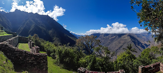
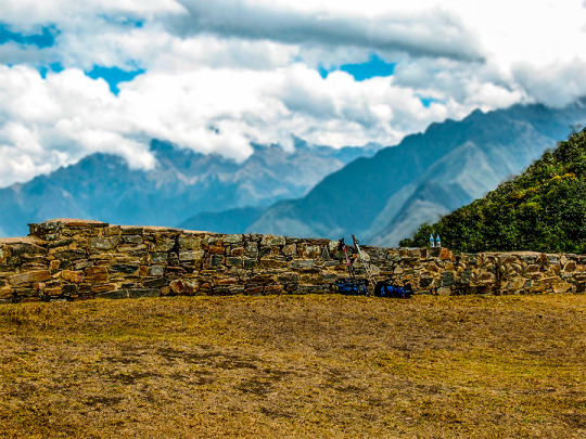
Choquequirao is located on the border of the department of Apurímac and Cuzco, the archaeological site of Choquequirao was not built to be a place that is accessed as if in passing, and now reaching it demands two days of disciplined march, largely offset by beauty of the landscape that accompanies the walker from his first steps.
The journey begins in Cachora (2,800 m.a.s.l.), a small town in the department of Apurimac which is reached, having departed from Cuzco, after four hours of good road (145 km asphalted and 10 km affirmed). It is there where the mule muleteers are contacted, who also act as guides. A local family offers lodging and the only phone in the town.
Walk to Choquequirao Currently the trek to Choquequirao (trekking) has become one of the best alternatives to the famous Inca Trail to Machu Picchu, with which it competes in scenic beauty and adventure. The traditional route is Cachora, Coca Masana, Rosalina Beach, Choquequirao, Raqaypata, Chikisca, Cachora. There are also walks that link Machu Picchu with Choquequirao. Normally the adventure begins in the city of Cuzco, on a road trip of 93 km (3h 30 'by car) to the town of Cachora at 2,300 meters above sea level, and from there a 30-kilometer walk starts in 4 or 5 days, with a total of 60 kilometers, crossing areas of abundant and varied vegetation and fauna from the high Andean zone to the jungle, crossing the Apurimac river canyon.
Tour operators offer the service of guides and porters and all the logistics required for the walk. More information of Choquequirao Trek
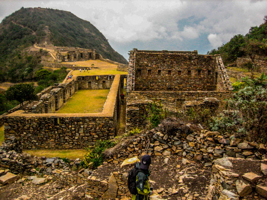
Choquequirao has only been excavated 30%. Despite this, it already has several very important Inca constructions:
Main square: the main square or Huaqaypata divided the site in two. It is a two-story stone construction. Next to him, there are other buildings connected to each other.
Colcas - Typical buildings of the main Inca centers. In Choquequirao, these platforms have internal subdivisions. The purpose of these deposits was to store products for food, clothing and others.
Platforms: Choquequirao has a significant number of platforms for cultivation. In the western sector there are 22 flame-shaped engravings arranged on 15 platforms. These figures are known as the ‘Flames of the Sun’.
Housing: in the highest part of Choquequirao, there are up to 5 buildings whose purpose was probably housing for the priests of the enclosure. It is believed that this Inca site was an important ceremonial center.
Inca Cemetery - Also known as the ‘Triunfal Wall’. 17 funeral bullets and a water gutter called "The House of the Water Fall" were found.
Kallankas: these rectangular buildings had multiple functions, such as workshop, administrative center, meeting space, etc. In Choquequirao there are 2 Kallankas on whose walls there were canals that supplied water.
Ushnu: This oval platform construction is located on top of a hill. Due to the surrounding wall and the privileged view of the snow-capped mountains, the river and the whole enclosure; It is believed that it had a religious purpose.
The lost city of the Incas of Choquequirao was probably built in the fifteenth century, along with the city of Machu Picchu, during the administration of the Inca Pachacútec. However, this statement is contradicted by other historians who claim that its construction was later than Pachacútec, during the governments of Túpac Yupanqui or Huayna Cápac. Choquequirao Trek Information
In the Inca era, Choquequirao was a very important cultural and religious center that served as a commercial enclave and waypoint to Vilcabamba and Machu Picchu.
During the Inca resistance to the Spanish invasion, Choquequirao was one of the last bastions of resistance and Inca refuge. But, at the fall of the great Inca culture, the Inca people of Choquequirao passed to the forgotten one, and the immeasurable jungle was responsible for hiding it for many centuries.
Just in the early 1800s, the first explorers began to explore the lost city of Choquequirao.
But, it was not until the end of the 1990s that intensive studies began and the restoration plan began.
Currently, of the 1810 hectares comprising the Inca Llaque of Choquequirao, only 30% have been unearthed and put into operation as a tourist area. While 70% of the ruins still lie under the frond of the jungle eyebrow.
Structure
Unlike Machu Picchu, the Archaeological Ensemble of Choquequirao is a dispersed and varied settlement.
Its architectural structure was built with edged stones and mud mortar, and is composed of:
A ceremonial platform (Ushno).
An upper square (Hanan) and a lower square (Hurin).
Temples
Niches
Housing of the priests.
Deposits and barns (Qolqas).
Ditch network.
And a platform system.
Choquequirao sectors
Choquequirao is organized in 12 separate sectors (zones), whose paths converge to a large main square.
Sector I. Located in the highest part, in the Hanan area. It includes an upper main square, buildings and an aqueduct that descends through successive stone fountains (phacchas).
Sector II Located in the Hanan area, below sector I. It includes the Warehouses and warehouses (qolqas) and the “Giant Stairs” stairs of Bingham.
Sector III It is the central nucleus of the citadel. It is located in the upper (hanan) and lower (hurin) sectors. It is made up of the main square or Hauqaypata, some annexed buildings of one and two levels (houses of the rulers and Kallankas).
Sector IV Located in the Hurin or South zone, it is a main building composed of five covers that were probably used for ceremonial uses. In this place is the Temple of the triumphal wall and the sacred pens.
Sector V (Ushnu). Located on top of a hill. It presents a ceremonial oval platform that is surrounded by a small wall. From this place you can see much of the archaeological park of Choquequirao, the mountain range of the Vilcanota Range and the great Apurimac canyon.
Sector VI (Wasi Cancha). It is located south of the ushnu, in the lower part. Also known as temple and housing of priests.
Sector VII. Formed by cultivation platforms on the east side (monumental platforms or sacred platforms), which stand out for hosting wide and wide platforms.
Sector VIII. Made up of 80 platforms, divided into plots and water channels that descend from the main square. Here are the famous "platforms of the Flames of the Sun"
Sector IX. Constituted by popular or family homes. It is better known as Pikiwasi.
Sector X (Paraqtepata). Formed by 18 cultivation platforms and irrigation canals parallel to the stairs.
Sector XI. Located in the area called Phaqchayoq, on the right bank of the Ch’unchumayo stream. It is composed of 80 wide platforms.
Sector XII In this sector are the cultivation platforms. It is made up of 57 platforms with permanent irrigation.
Spectacular and distant, lonely and forgotten, Choquequirao (3,085 masl) is ruled on the top of an almost impregnable mountain in the province of La Convencion, department of Cusco, reason that made it for more than 40 years the last bastion of resistance of The children of the Sun, who sought refuge in their stone walls, after the defeat of Manco Inca, the rebel Inca, will visit palaces, two-level temples, fountain systems, canals, aqueducts, and their admirable "upholstered" profuse platform Vegetation, a place worth the effort. The fatigue yields to the magnificence of Choquequirao.
More Information of Choquequirao Trek
The geographical location is northeast of Cusco between the rivers of Apurimac, Urubamba and the majestic Salkantay with a maximum height of 6,271msnm and a minimum of 2,575 meters above sea level. The Vilcabamba range offers the unique opportunity of a fascinating hike between an environment of glaciers, green mountains, bears, condors, tarantulas, etc. This cloud forest region served as a refuge and natural fortress for the 16th Inca resistance movement of the 16th century, which sought to regain control of the Tahuantinsuyo from Spanish invaders. The customs and clothes typical of local people reflect a mixture of cultures. Its tongue and textiles with Inca and Pre-Inca ornaments, give clear evidence of the influence of the Quechuas. Vilcabamba is also the region where there is a concentration of Pre-Columbian archaeological treasures, including Choquequirao and the famous citadel of Machu Picchu. There is a network of operation of the Inca roads that connects the pampas of Vitcos, Rosas pata and Espiritu Pampa.