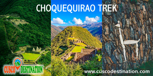
You can visit the architectural complex Choquequirao is situated in Vilcabamba at 3100 meters, considered the last Inka refuge and place of resistance from the invaders, when doing ....
Our Inca Jungle Trail classic To Machu Picchu combines adventure sports such as mountain biking, rafting, zip line, hot spring and trekking for 4 days until you reach Machu Picchu....
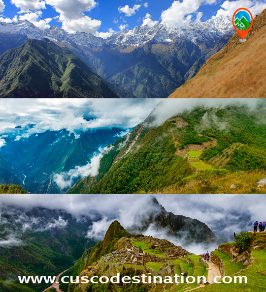
In the upper area close to the Skies, the Incas built one of their best-preserved cities, now recognized as one of the 7 wonders of the modern world. Many travelers and adventurers come....
According to the research, the coloration of the rainbow mountain is due to the composition of minerals that it has: the pink color is for the red clay, fangolitas and arilitas. The whitish, for the quartzose ...
Showing posts with label choquequirao to machu picchu. Show all posts
Showing posts with label choquequirao to machu picchu. Show all posts
The Choquequirao fortress is located in the Vilcabamba area, where the Incas of the Manco dynasty resisted the Spanish conquerors for 36 years (1536 - 1572), who never managed to expel them from it.
The construction of Choquequirao is the work of the successors of the Inca Pachacútec, Túpac Inca Yupanqui (1471 - 1493) and Huayna Cápac (1493 - 1527). In the place, domestic and ceremonial ceramics of the classic Cuzco style were used, as well as others, typical of the population that moved to build and populate the site permanently, probably farmers experienced in building and exploiting agricultural platforms in eyebrow areas jungle.
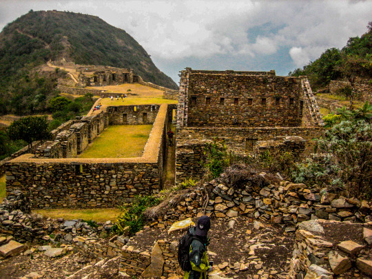
Approximately 40% of the Inca ceremonial center of Choquequirao is free of vegetation and restoration and enhancement work is currently being carried out. The remaining area is formed by a complex system of platforms built on very steep slopes. A short time ago, an impressive 180-platform staircase has been located that descending from one of the flanks of the ceremonial center reaches the river, where it is possible to swim.
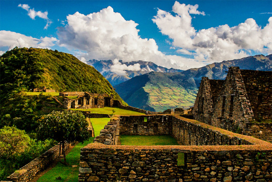
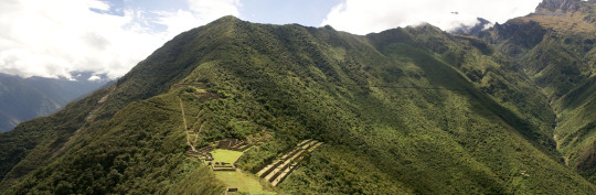
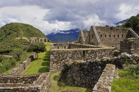
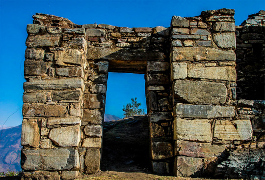
Choquequirao was possibly one of the entry control points to the Vilcabamba region, and as such an administrative nucleus with political, social and economic functions. In its urban conception it followed the symbolic patterns of the imperial capital with places of worship dedicated to the Sun, ancestors, land, water and other divinities, royal residences, houses of administrators and artisans, warehouses, large dormitory buildings or Kallancas and agricultural platforms of the Inca and the town. The ceremonial area extends over 700 meters, with a level difference of up to 65 meters between the main square and the highest parts. The complex consists of nine stone architectural groups and a system of 180 platforms, apart from the areas of residential, administrative, craftsman, irrigation system, among other buildings built on a stone base.
The sectors that are defined by the topography of the place had different functions and communicated through pedestrian access to the main square. You can see a complex hydraulic system probably designed for domestic, ceremonial and agricultural use.
Given the geographical location of Choquequirao, compared to other complexes of the same period, it seems that it had the function of being an Inca enclave towards the hot valleys of the Apurimac River. Its inhabitants dedicated to intensive agriculture and performed ceremonies where water was an important element of worship. In addition, it was a storage place for various products from other areas, as well as a connection between the valleys of Apurimac, Vilcabamba and Vilcanota.
Choquequirao is located on the border of the department of Apurímac and Cuzco, the archaeological site of Choquequirao was not built to be a place that is accessed as if in passing, and now reaching it demands two days of disciplined march, largely offset by beauty of the landscape that accompanies the walker from his first steps.
The journey begins in Cachora (2,800 m.a.s.l.), a small town in the department of Apurimac which is reached, having departed from Cuzco, after four hours of good road (145 km asphalted and 10 km affirmed). It is there where the mule muleteers are contacted, who also act as guides. A local family offers lodging and the only phone in the town.
Walk to Choquequirao Currently the trek to Choquequirao (trekking) has become one of the best alternatives to the famous Inca Trail to Machu Picchu, with which it competes in scenic beauty and adventure. The traditional route is Cachora, Coca Masana, Rosalina Beach, Choquequirao, Raqaypata, Chikisca, Cachora. There are also walks that link Machu Picchu with Choquequirao. Normally the adventure begins in the city of Cuzco, on a road trip of 93 km (3h 30 'by car) to the town of Cachora at 2,300 meters above sea level, and from there a 30-kilometer walk starts in 4 or 5 days, with a total of 60 kilometers, crossing areas of abundant and varied vegetation and fauna from the high Andean zone to the jungle, crossing the Apurimac river canyon.
Tour operators offer the service of guides and porters and all the logistics required for the walk. More information of Choquequirao Trek
Choquequirao has only been excavated 30%. Despite this, it already has several very important Inca constructions:
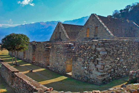
Main square: the main square or Huaqaypata divided the site in two. It is a two-story stone construction. Next to him, there are other buildings connected to each other.
Colcas - Typical buildings of the main Inca centers. In Choquequirao, these platforms have internal subdivisions. The purpose of these deposits was to store products for food, clothing and others.
Platforms: Choquequirao has a significant number of platforms for cultivation. In the western sector there are 22 flame-shaped engravings arranged on 15 platforms. These figures are known as the ‘Flames of the Sun’.
Housing: in the highest part of Choquequirao, there are up to 5 buildings whose purpose was probably housing for the priests of the enclosure. It is believed that this Inca site was an important ceremonial center.
Inca Cemetery - Also known as the ‘Triunfal Wall’. 17 funeral bullets and a water gutter called "The House of the Water Fall" were found.
Kallankas: these rectangular buildings had multiple functions, such as workshop, administrative center, meeting space, etc. In Choquequirao there are 2 Kallankas on whose walls there were canals that supplied water.
Ushnu: This oval platform construction is located on top of a hill. Due to the surrounding wall and the privileged view of the snow-capped mountains, the river and the whole enclosure; It is believed that it had a religious purpose.
The lost city of the Incas of Choquequirao was probably built in the fifteenth century, along with the city of Machu Picchu, during the administration of the Inca Pachacútec. However, this statement is contradicted by other historians who claim that its construction was later than Pachacútec, during the governments of Túpac Yupanqui or Huayna Cápac. Choquequirao Trek Information
In the Inca era, Choquequirao was a very important cultural and religious center that served as a commercial enclave and waypoint to Vilcabamba and Machu Picchu.
During the Inca resistance to the Spanish invasion, Choquequirao was one of the last bastions of resistance and Inca refuge. But, at the fall of the great Inca culture, the Inca people of Choquequirao passed to the forgotten one, and the immeasurable jungle was responsible for hiding it for many centuries.
Just in the early 1800s, the first explorers began to explore the lost city of Choquequirao.
But, it was not until the end of the 1990s that intensive studies began and the restoration plan began.
Currently, of the 1810 hectares comprising the Inca Llaque of Choquequirao, only 30% have been unearthed and put into operation as a tourist area. While 70% of the ruins still lie under the frond of the jungle eyebrow.
Structure
Unlike Machu Picchu, the Archaeological Ensemble of Choquequirao is a dispersed and varied settlement.
Its architectural structure was built with edged stones and mud mortar, and is composed of:
A ceremonial platform (Ushno).
An upper square (Hanan) and a lower square (Hurin).
Temples
Niches
Housing of the priests.
Deposits and barns (Qolqas).
Ditch network.
And a platform system.
Choquequirao sectors
Choquequirao is organized in 12 separate sectors (zones), whose paths converge to a large main square.
Sector I. Located in the highest part, in the Hanan area. It includes an upper main square, buildings and an aqueduct that descends through successive stone fountains (phacchas).
Sector II Located in the Hanan area, below sector I. It includes the Warehouses and warehouses (qolqas) and the “Giant Stairs” stairs of Bingham.
Sector III It is the central nucleus of the citadel. It is located in the upper (hanan) and lower (hurin) sectors. It is made up of the main square or Hauqaypata, some annexed buildings of one and two levels (houses of the rulers and Kallankas).
Sector IV Located in the Hurin or South zone, it is a main building composed of five covers that were probably used for ceremonial uses. In this place is the Temple of the triumphal wall and the sacred pens.
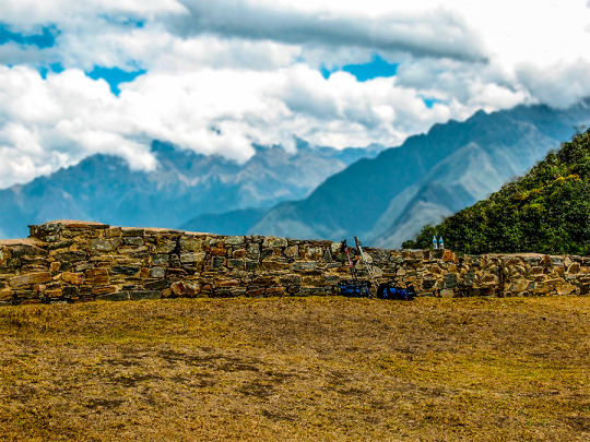
Sector V (Ushnu). Located on top of a hill. It presents a ceremonial oval platform that is surrounded by a small wall. From this place you can see much of the archaeological park of Choquequirao, the mountain range of the Vilcanota Range and the great Apurimac canyon.
Sector VI (Wasi Cancha). It is located south of the ushnu, in the lower part. Also known as temple and housing of priests.
Sector VII. Formed by cultivation platforms on the east side (monumental platforms or sacred platforms), which stand out for hosting wide and wide platforms.
Sector VIII. Made up of 80 platforms, divided into plots and water channels that descend from the main square. Here are the famous "platforms of the Flames of the Sun"
Sector IX. Constituted by popular or family homes. It is better known as Pikiwasi.
Sector X (Paraqtepata). Formed by 18 cultivation platforms and irrigation canals parallel to the stairs.
Sector XI. Located in the area called Phaqchayoq, on the right bank of the Ch’unchumayo stream. It is composed of 80 wide platforms.
Sector XII In this sector are the cultivation platforms. It is made up of 57 platforms with permanent irrigation.
CHOQUEQUIRAO es un lugar tan maravilloso como Machu Picchu; menos conocido, más inexplorado. Virgen y libre de la abundante visita turística. Un Machu Picchu para llegar como mochilero, con largas caminatas independientes y acampadas en la ruta. Choquequirao es también conocida como la hermana sagrada de Machu Picchu. Se trata pues de un gran complejo arqueológico con edificios y terrazas, testimonio de los Incas conquistando las alturas de las montañas.
En esta guía aprenderás cómo llegar por tu cuenta a este santuario. Aprovecha los recursos de Cusco destination para descubrir una de las ruinas más impresionantes de Latinoamérica.
Antes debes saber un par de cosas:
¿Por qué si es tan increíble va tan poca gente o se sabe poco de él?
A diferencia de Machu Picchu a donde se puede llegar con trenes y ascender en buses, Choquequirao es un destino al que se llega a través de un intenso sacrificio y esfuerzo. Son caminatas duras que implican bajadas y desniveles con poco oxígeno. La manera de llegar es caminando mucho y acampando. Posiblemente tu abastecimiento de agua no sea suficiente, pases frío en las alturas o bien te quemes caminando bajo el intenso sol andino. El viaje completo puede hacerse entre 4 y 5 días salvo que quieras visitar algunos pueblos aledaños o hacerlo rápidamente.
¿Cuánto se camina hasta Choquequirao?
Desde el poblado de Cachora hasta Choquequirao se caminan alrededor de 31 kilómetros sin incluir el recorrido por las ruinas. De regreso sería la misma distancia (62 km en total). Una gran parte del recorrido implica la bajada de una gran montaña mientras que la otra mitad es en una subida.
¿Aqué altura está Choquequirao?
La ciudadela se encuentra a 3,035 m.s.n.m y en el punto más bajo de la caminata estarás a 1,461 m.s.n.m. El clima es similar al de Cusco por lo que es recomendable acondicionarte a las alturas antes de la caminata.
Machu Picchu without hesitation is considered as the tourist icon of Peru, and of the more than 3 million tourists who visit us a year, more than 98% have a look at Meet Machu Picchu. However, in Peru there are places that can also be considered a tourist icon of Peru, but due to the little marketing they are given, it does not become known as Machu Picchu is now. informacion de Choquequirao Trek.
CHOQUEQUIRAO: Considered by many tourists who visited it like the other Machu Picchu and sometimes many tourists dare to say that it is better than Machu Picchu. The best thing about this archeological center is that it can only be accessed by walking as it does not exist, railways or roads that can take you to or near Choquequirao, so it is done full trekking many tourists consider this crossing as a Pilgrimage, an escape from the routine, an own challenge, escape from the bustle of the city, and being not well known sometimes the route is empty (without tourists) and on other occasions one can run into some tourists and these are few . Of course, sometimes the route can be full of tourists (nationals, school promotions and foreign tourists.). But almost the whole year the route is with few tourists. Choquequirao tour or trek: being a not very well-known or popular route, it is difficult to gather groups, so most of the time it is operated only in private service, thus raising operating costs. As an example, only the transportation service from Cusco in a minivan to Cachora, which is a starting point, costs around 300 to 400 dollars per way and another one equal to return. To this cost must be added the fees of the guide, Cook, freight forwards, fee of the person in charge of the commonly known as arriero, also the costs of food, tents, gas, agency fee, taxes, etc. All these costs make an organized excursion from Cusco to Choquequirao very expensive, and this causes many tourists to be discouraged from doing so and looking for other options or trying to do it on their own.
This is a spectacular hike through the Andes of Peru. You can visit the architectural complex of Choquequirao, which is situated in Vilcabamba at 3100 meters, and is considered the last Inka refuge and place of resistance from the invaders. When doing this trek you will enjoy hiking in beautiful scenery, you'll see the impressive Apurimac Canyon, you’ll see flora and wildlife in the path. This route offers a strenuous but formidable journey due to the various existing ecosystems. Information of Choquequirao Trek
Useful Information
- Starting Altitude - 2900m / 9515ft. - Highest Altitude - 3050m / 10,005ft - Walking Distance - 64 km / 40 miles - Longest Day - Day 1, approximately 25 km/15.5 miles - Overall Difficulty - Difficult
IMPORTANT INFORMATION:
Because of its altitude, Choquequirao has a temperate climate. However, it should be noted that the road to Choquequirao is warm because of the Apurimac canyon. Choquequirao was presumably used as a control site to ensure access to areas of Vilcabamba, connecting the jungle with other major centers like Pisac and Machu Picchu. The archaeological remains of Choquequirao are comprised of buildings and terraces on different levels, in which their terraces stand out due to 22 carvings on stone with figures known as "Llamas del Sol" arranged in 15 platforms towards the snowy Qori Hauyrachina. Choquequirao features a large system of platforms/terraces.
Brief Itinerary - Day 1: Cusco – Cachora – Chiquiska. - Day 2: Chiquiska – Choquequirao. - Day 3: Choquequirao - Day 4: Choquequirao – Coca Masana. - Day 5: Coca Masana - Cachora – Cusco.
t is located at 13 ° 32 'south latitude and 72 ° 44' west longitude. It is located at 3035 m.a.s.l. in the foothills of the snowy Salcantay, north of the Apurimac river valley, in the province of La Convencion in the department of Cusco. It is approximately at a distance of 47 km. with reference to the town of Cachora (department of Apurimac).
We can mention that the Choquequirao environment is one of the richest in biodiversity. All these species have been conditioned despite temperature variations such as sun throughout the day and inclement frosts during the night. The fauna of the place is mainly composed of condors, tarucas, vizcachas, foxes, skunks, pumas, hummingbirds, spectacled bears and the popular rooster of the rocks, national bird of Peru. Giant ferns, ichu and a great variety of orchids stand out in its flora, where the wakanki variety stands out. Weather
Because of its geographical position, Choquequirao trek has a warm climate alternated with cold temperatures at night. The average annual temperature is 17ºC. History
During the Inca civilization it was a cultural as well as religious center for the region. Well, it is presumed that this citadel was used as a checkpoint to ensure access to the areas of Vilcabamba, which connected the jungle with other important centers such as Písac and Machu Picchu. It is also estimated that the citadel played an important role serving as a link between the Amazon rainforest and the capital of the Inca empire (Cusco).
At the time of transition that lasted approximately 40 years, Choquequirao is considered one of the last strongholds of resistance and refuge of the Incas, who by orders of Manco Inca, left the city of Cusco to protect themselves in the cities of the Vilcabamba region, when around 1535 Cusco was controlled by the Spanish. It was in this place (and in general throughout the Vilcabamba Valley) where Manco Inca and the last Inca descendants of Vilcabamba where they resisted the attack of the Spaniards, until the capture and execution of Túpac Amaru I that happened in the year 1572.
Choquequirao known as the sacred sister of Machu Picchu because it has a structural and architectural similarity, the archaeological monuments are made up of terraces distributed at different levels which were leveled and fenced with stones to form a platform with an area of approximately 150 square meters.
More Information: Choquequirao Trek
Location The ruins of Choquequirao are located at 13 ° 32 ’latitude and 77 ° 44’ west longitude, it is located 3033 meters above sea level in the snowy mountains of Salkantay north of the Apurimac river in the district of Santa Teresa province of the convention department of Cusco.
How to get Currently to reach the last Inca fortress is the land route, the best known route of how to get to Choquequirao is taking the road to Abancay, and at km 154 choose the detour that will lead you to the town of Cachora.
The route to Choquequirao has narrow roads which you have to walk very carefully, also have a good physical condition and the appropriate equipment for this walk.
Weather Due to its height, Choquequirao enjoys a mild climate. However, it is necessary to highlight that the Choquequirao road is warm due to the Apurimac canyon.
The ruins of Choquequirao are an ancient Inca city located between the mountains belonging to the snowy Salkantay in Cusco.
In 1909, the American explorer Hiram Bingham visited this place of difficult access. However, it was not until the mid-1970s that the first excavations of this archaeological site began.
Currently only 30% of the immense site was excavated. Despite this it is one of the most mysterious tourist attractions due to its similarity with Machu Picchu.
It is known as the last Inca refuge due to the belief that the remnants of Manco Inca were hidden there after the Spanish conquest.
It is also known as the ‘Sacred Sister of Machu Picchu’ due to the architectural similarity with the Inca Citadel.
The only way to get there is through a 2-day hiking trail along rivers, high mountains and breathtaking landscapes.
Machu Picchu is an Inca site located in the eastern part of the central Andes.
It belongs to the foothills of Salkantay, in southern Peru.
It is believed that this site was the urban, religious center and residence of the Inca Pachacutec, who commanded its construction in the early fifteenth century.
With the Spanish conquest, the place was gradually abandoned until it was covered by the abundant vegetation characteristic of the area.
In 1911, the American explorer Hiram Bingham made known to the world the importance of the archaeological complex.
In 2007, the Inca llaqta was chosen as one of the Wonders of the modern World. Since then, tourist traffic has skyrocketed.
Today, its mysterious stone constructions around beautiful mountainous landscapes are one of the most visited places on the planet.
It is estimated that around 1 million people visit it a year.