You can visit the architectural complex Choquequirao is situated in Vilcabamba at 3100 meters, considered the last Inka refuge and place of resistance from the invaders, when doing ....
Our Inca Jungle Trail classic To Machu Picchu combines adventure sports such as mountain biking, rafting, zip line, hot spring and trekking for 4 days until you reach Machu Picchu....
In the upper area close to the Skies, the Incas built one of their best-preserved cities, now recognized as one of the 7 wonders of the modern world. Many travelers and adventurers come....
According to the research, the coloration of the rainbow mountain is due to the composition of minerals that it has: the pink color is for the red clay, fangolitas and arilitas. The whitish, for the quartzose ...
Showing posts with label trek to machu picchu. Show all posts
Showing posts with label trek to machu picchu. Show all posts
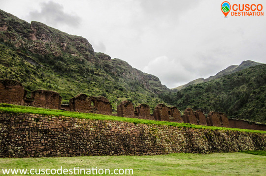
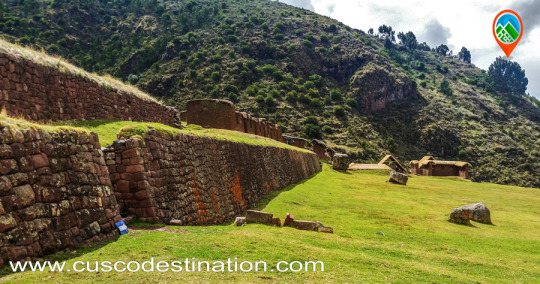
This complex is the most important archaeological center in the Urubamba Valley, after Ollantaytambo and Pisac. The ruins are impressive, although the conservation of the site is inferior to that of Ollantaytambo or Pisac, because they are older.
But unlike the places mentioned above Huchuy Qosqo has a peculiar architecture: the buildings have been built on polished stone bases of fine finish, with clay plaster (they are the best preserved parts) and the highest floors are made of adobe.
There is a kallanka (rectangular enclosure that could measure up to 70 meters long and that were important state centers where Inca officials were staying) of at least 40 to 50 meters long. Also a remarkable building with two stone floors and an adobe upper one. There are also large terraces, a very large square and a large Inca gate through which a very well preserved road leads from Tambomachay.
The Hispanic chronicles indicate that Huchuy Qosqo (probably a site known in Inca times as Caquia Jaquijahuana) was the work and favorite place of the Inca Wiracocha. To this, Maria Rostworoski adds, in her work "History of Tahuantinsuyo", that this sovereign strengthened the conquest over the villages of the Urubamba valley and that he chose as his successor his son Inca Urco who, dizzy with power and vice, He proved to be totally unable to govern. The Inca royalty was very obfuscated with this election and tried to conspire to impose another son of Wiracocha, Prince Cusi Yupanqui. Social unrest and tension increased every day and to make everything worse, the darkest night fell over Cuzco: the Chancas reached the gates of the capital and were willing to destroy it. It is the year of 1438. Wiracocha leaves the city to his fate and, accompanied by his son Inca Urco, takes refuge in its palaces in the Urubamba Valley, among which was Huchuy Qosqo.
After the Hispanic conquest, Gonzalo Pizarro found here the mummy that supposedly belonged to the Inca Wiracocha and ordered it burned. The descendants of the Inca kept the ashes in a jar that many years later the chronicler Polo de Ondegardo would discover. HOW TO VISIT: It is possible to visit Huchuy Qosqo in three ways, the first one walking from Cusco and Tambomachay along the Inca trail. The other way is up from the Sacred Valley after crossing the Wilcamayo River (now Vilcanota), from Chinchero. HUCHUY QOSQO TREK INFORMATION.
This complex is the most important archaeological center in the Urubamba Valley, after Ollantaytambo and Pisac. The ruins are impressive, although the conservation of the site is inferior to that of Ollantaytambo or Pisac, because they are older. But unlike the aforementioned places Huchuy Qosqo has a peculiar architecture: the buildings have been built on polished stone bases of fine finish, with clay plaster (they are the best preserved parts) and the highest floors are made of adobe.
Useful Information
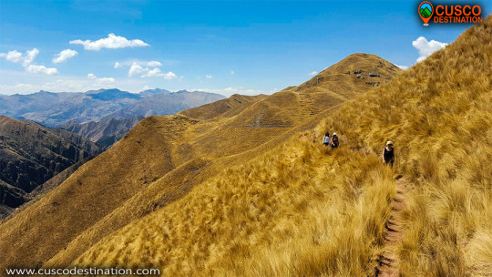
- Starting Altitude - 3848 meters / 12624 feet. - Highest Altitude - 4150 meters / 13615 feet. - Walking Distance - 12 km / 7.46 miles - Overall Difficulty - Moderate - STARTING POINT: - Cusco at your hotel
IMPORTANT INFORMATION:
The Hispanic chronicles refer that Huchuy Qosqo (probably a place known in Inca times as Caquia Jaquijahuana) was the favorite work and place of the Inca Wiracocha. A kallanka of at least 40 to 50 meters long is observed. Also a remarkable building with two stone floors and one upper one of adobe. There are also large terraces, a very large square and a large Inca gate through which passes a very well preserved road that leads from Tambomachay.
Brief Itinerary - OPTION 1: CUSCO – TAUCA – HUCHUY QOSQO – CUSCO - OPTION 2: CUSCO - TAMBO MACHAY - PUCAMARCA - HUCHUY QOSQO - CUSCO HUCHUY QOSQO TREK INFORMATION
The archeological zone of Huchuy Qosqo (Cusco Small), which was known during the Inca period as Qaqyaqawana (which in Spanish means “place from where you see the thunder”), is located in the district of Lamay, within the province of Calca, in the department and region of Cusco, specifically in a plain found on the top of a mountain. At a height of 3 550 meters above sea level. And it is currently considered, thanks to the National Institute of Culture, as Cultural Heritage of the Nation. HUCHUY QOSQO ROUTE TO MACHU PICCHU INFORMATION:
On a historical level, this site is known as the preferred place of the Inca Wiracocha, which he chose as a place of rest and retreat and, where, according to the myth, he died at an advanced age (80 years old). It is also said that this area was already populated by different ethnicities, before the Inca arrival, so they had to be previously defeated. Another striking story about the area is that the Inca Wiracocha had not come only there, but in the company of his son: Inca Urco, the worst ruler of the Empire, who abandoned their Tahuantinsuyo fate after the Chanca attack that ended up being stopped by his other son Cusi Inca Yupanqui. Finally, another reason that makes this site important is the discovery of a mummified body, found during the Conquest, and that would have been attributed to the old Inca monarch, although later burned by Francisco Pizarro's brother.
As for its location, it can be added in addition to the access feature, which provides the visitor (and those who lived in the archaeological center) a great view of the snowy Pitusiray along with the town of Calca.
Regarding the architectural remains that have still been preserved on the site, we can say of them that there are at least 2 buildings, in addition to the presence of platforms and cliffs. Among the buildings, built on the basis of some of stone and others of adobe, we can observe, one of three floors, without name; This first construction is characterized by the presence of the mixture of the construction materials, since the two lower levels are made of carved stone, while the last one preserves adobe-based structure. The second building, also without a name, is a rectangular-based construction, made with adobones, which is believed to have had the purpose of being a space for the labor learning of the women of the Empire. There are also vestiges of remains of smaller enclosures that are almost destroyed due to natural events, including rains and vegetation in the area.
To get to the place the exact location of Huchuy Qosqo is necessary to make a walk, due to the narrow road, it lasts 3 hours from Lamay; on the other hand you can also go from Chinchero, using half a day of pilgrimage; and if you want to make a trip to the site, of longer duration, in which camping is required, you can take the route from the City of Cusco, since this route takes the entire day. The entrance to the site is totally free, although it is recommended that the tourist be done in the company of guides or in groups; Another recommendation is that this tour be carried out in the dry weather period, between the months of April and October, to avoid the slippery area due to the rains.
Ollantaytambo is another of the many places where we can admire the archaeological wealth that the Incas left us. It is a population that is part of the province of Urubamba and the department of Cusco.
It is located at the convergence of two valleys crossed by the Vilcanota, which the Incas called Willcamayu (Sacred River) and the Patacancha. At an altitude of 2,790 m.a.s.l.
One of the routes I do frequently, is towards the Inca quarries of Cachiccata. The last ascents I have initiated from the Inca bridge that is at the entrance of Ollantaytambo coming from Urubamba. This bridge consists of two eyes over the Vilcanota River (or Urubamba River). Its bases, of Inca origin, are made up of large blocks of stone and, to protect the central pillar, they placed two huge rocks as a water-breaker in the course of the river. In its origin, this bridge must have been a suspension, and like so many others that the Incas did, it was made with the braiding of a plant called “ichu”, which is still used today on the roof of many Andean houses.
INFORMATION OF INCA QUARRY TREK
Once across the bridge, the ascent begins on the left bank. A sign shows us the route to follow, while we have a good view of the platforms that surround Ollantaytambo.
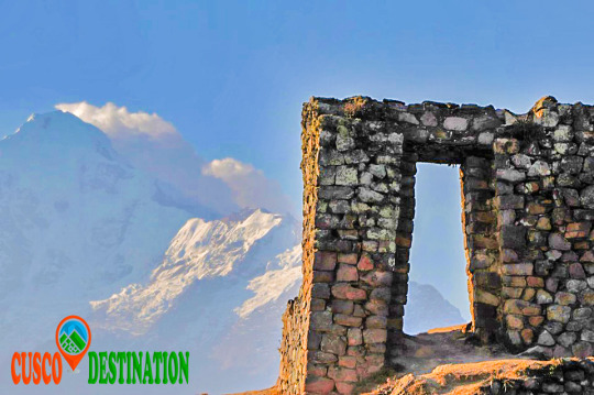
In front of the train station we will encounter a rocky ledge on which there are the ruins of a control or defensive fort known as Choquequillca. On the other side of the Vilcanota River (right bank) we found no fortification, perhaps because it was destroyed with the layout of the railway. Our goal is to visit the Cachiccata quarries and then continue the ascent to the top of the Arequipa Hill, where there is an Inca archaeological structure, known as INTI-PUNKU (Puerta del Sol). The distance between the Inca bridge of Ollantaytambo and the INTI-PUNKU is about 8 km with 300 m. following a pedestrian trail. This journey can be done in one day without trying to break records. It is convenient to get up early to avoid the intense midday sun.
The initial road runs parallel to the Vilcanota River, with terraces on the left side. In front, on the other side of the river, we can contemplate another architectural group of the Inca culture; It is called Raqaypata.
A second part of the road, much wider, takes us to the bottom of the Cachiccata quarry (in Quechua it means “salt slope”). It is a continuous ascent to save the 400 m. of unevenness between the starting point (2800 m altitude on the Ollantaytambo bridge) and this lower quarry located at 3210 m.a.s.l.
Along this second journey, which is one of the ramps through which the Incas slid the pink stone blocks, we found some of these large stones that did not reach their destination and are known as “ Tired Stones. "
Here are two copies: the first one is located in front of the church of San Santiago Apostol (Ollantaytambo) and the second one is found on the way up to the quarry.
It is not uncommon to find tour groups accompanied by a guide, and pack animals transporting the materials of a long journey. It is also common to find people picking aromatic or medicinal plants (muña, tara, ...) It is obligatory for me, when visiting these places, to visit Don Guillermo Qawa; an old man who lives alone at 3022 m altitude and with whom I share a “little time” of company and some food, every time I make this route.
Why not mention the children Francisco, Roqui, Yéssica, Lourdes and Lisbeth to whom on this last walk we offered the promised toys?
The Cachiccata quarries are located under the impressive Black Good Apu from which the Incas extracted the huge blocks of pink rhyolite. These stones were partially worked in the quarries and then down to the Vilcanota River in front of the Rumira sector.
Through an artificial channel parallel to the riverbed, they diverted the water alternately (in times of drought) and thus moved the blocks on either channel with an island in the middle. The blocks were dragged back to the fortress of Ollantaytambo.
The last section consisted of a steep ramp, which can be seen perfectly from the left bank of the river, as shown by the arrow in the photograph. We know, from the tools that the Incas abandoned in the quarry, that they used the same stone for the extraction of the blocks: granite and basalt strikers, obtained in the Vilcanota River. These quarries had to be abandoned when Manco Inca retired from Ollantaytambo.
The last section consisted of a steep ramp, which can be seen perfectly from the left bank of the river, as shown by the arrow in the photograph. We know, from the tools that the Incas abandoned in the quarry, that they used the same stone for the extraction of the blocks: granite and basalt strikers, obtained in the Vilcanota River. These quarries had to be abandoned when Manco Inca retired from Ollantaytambo.
As for the transfer of the immense stones, we do not stop questioning the time, the way and the enormous amount of people contributing their strength and ingenuity. There is no doubt that the Inca people were construction experts; his numerous works that still endure so testify: Coricancha, Sacsayhuamán, Ollantaytambo, etc.
In the northern (lower) quarry of Cachiccata there are small constructions known as “CHULLPAS”. They are tiny towers of circular base, built with stones joined with mortar of red mud and straw. These are funerary constructions that abound in the Highlands of Peru and Bolivia, typical of the Qollas.
Those of Cachiccata, due to their small size, we deduce that they served as burial for a single person, in which they generally placed the deceased in fetal form along with some of their belongings. They have an opening or entrance in a rectangular shape and have the upper part or roof covered. Some are very damaged and others have completely disappeared; all have been looted by treasure hunters (Huaqueros).
At our feet is the small town that gives name to these quarries: CACHICCATA. A peasant community of about 80 families with approximately 320 people living on agriculture, especially corn and potatoes.
After replenishing forces, we continue the ascent to the west and south quarries. In both we find stones of greater size and better worked, as well as a limited enclosure in which the stones extracted from the quarry were stored and worked. From this place we can contemplate a spectacular landscape: · The wide valley crossed by the Vilcanota river with its diverse green tones, characteristic of the rainy months; and in the middle, the famous pyramid of Paccarectampu. Regarding this truncated pyramid of Ollantaytambo, certain writings relate it to the founding beginnings of the Inca Empire. What we can confirm is that during the winter solstice (June 21), with the sunrise, it is possible to observe different light effects through solar projections on this pyramid of Ollantaytambo.
· Al Al frete, the imposing peaks of the Vilcanota Range, among which the Apu (divinity) or Veronica Snow also known as Wakaywilque with its 5,682 m.a.s.l. struggling to peek her white hair between the clouds that surround her.
I was surprised to find in these quarries a stone wheel (like an old mill) apparently unfinished, because the central hole was completely unperforated.
Continuing our ascent, the next stop was at the archaeological remains of Choquetacarpo located at 3,495 m.s.n.m, of which we do not know the purpose they had, although it seems to have been the residence of those who managed the quarry.
The trip continues in its last stage of ascent until reaching 3,943 m.a.s.l. With your eyes fixed on the INTI-PUNKU (Puerta del Sol) and the desire to complete the feat of reaching that altitude, forces arise under the intense sun and dizziness from the height. MACHU PICCHU TOUR
They are the last meters, some steps and we access the Puerta del Sol. An impressive spectacle appears before our eyes. Mute and contemplate is the most appropriate. Praise be my Lord!
Cocalmayo thermal baths There is nothing better than taking a hot bath in nature, while enjoying a drink of “aguaymanto”. Taking a bath in the Thermal Baths of Cocalmayo, is a great experience. It is situated between a huge river and a small mountain. In Cocalmayo bathers can enjoy outdoor swimming pools fed by natural hot springs, built between a small mountain full of vegetation and the Urubamba river. You will find 3 swimming pools of different sizes and depths. The water temperature varies between 38 and 44 ºC and unlike most hot springs in Peru, it has clear waters. Cold showers are very close to the pools, the water comes from the Uripata lagoons and is very refreshing; The mixture of waters will give you a very comforting feeling.
Inca jungle to machu picchu The benefits: Located at 1,600 m.a.s.l. Its waters are rich in essential minerals such as sodium, magnesium, bicarbonate, calcium, sulfate and others, which have healing properties on the skin, bones, muscles and joints. Where are the thermal baths of Cocalmayo? The thermal baths of Cocalmayo are in the valley of the Urubamba River (Vilcanota) in a cozy and relaxing place, its naturally heated pools reach 44 ºC. They are located 20 minutes from the town of Santa Teresa in the province of the Convention, in Cusco - Peru; precisely at kilometer 135 of the railway line between Cusco and Quillabamba, at 1,600 m.a.s.l.