You can visit the architectural complex Choquequirao is situated in Vilcabamba at 3100 meters, considered the last Inka refuge and place of resistance from the invaders, when doing ....
Our Inca Jungle Trail classic To Machu Picchu combines adventure sports such as mountain biking, rafting, zip line, hot spring and trekking for 4 days until you reach Machu Picchu....
In the upper area close to the Skies, the Incas built one of their best-preserved cities, now recognized as one of the 7 wonders of the modern world. Many travelers and adventurers come....
According to the research, the coloration of the rainbow mountain is due to the composition of minerals that it has: the pink color is for the red clay, fangolitas and arilitas. The whitish, for the quartzose ...
What is the Inca Jungle at Machu Picchu? The Inca Jungle tour is a tour that departs from the City of Cusco and ends in Machu Picchu, after 4 days and 3 nights after performing a series of adventure sports such as: cycling, trekking, canoeing and zip line. The Inca Jungle is one of the most popular tours in Peru.
What is the Inca Jungle route? The Inca Jungle begins in the city of Cusco and ends in Machu Picchu. During the journey you cross the Sacred Valley of the Incas, then enter the jungle eyebrow of Cusco to finally arrive at the Wonder of the World. This is the route during the 4 days of the tour:
1st. day: Cusco - Abra Málaga - Santa María Town.
2nd. day: Santa María - Thermal baths - Santa Teresa town.
3rd. day: Santa Teresa - Hydroelectric - Aguas Calientes town.
4th. day: Aguas Calientes - Machu Picchu - Cusco.
What is the height during the Inca Jungle? The Inca Jungle runs through its highest point in the so-called ‘Abra Málaga’ (4,230 masl). The lowest point is in the town of Aguas Calientes (2,000 m.a.s.l.), also known as Machu Picchu town. Map of the Inca Jungle Machu Picchu The Inca Jungle begins in the city of Cusco. After doing various adventure sports, visit the Inca City of Machu Picchu. The return to the city of Cusco is by train and bus. What is the weather like during the Inca Jungle? The climate during the Inca Jungle is varied. The coldest point is in Abra Málaga (average temperature of 9ºC during the day). Then we descend to the tropical climate of the jungle eyebrow. The warmest point is in the town of Santa Teresa (day temperature up to 26ºC). What is the flora and fauna like during the Inca Jungle? The Inca Jungle is characterized by the beautiful landscapes during the tour. Along the way you can see vizcachas, llamas, spectacled bears, cock of the rocks and a wide variety of orchids. In addition, plantations of bananas, mangoes, oranges and more are crossed. Does 4 days seem too long for the Inca Jungle? There is another 3-day service, which accelerates the pace of the walks to reach Machu Picchu earlier. However, the most popular Inca Jungle tour is the one that lasts 4 days. What sports does the Inca Jungle include? The Inca Jungle includes the following adventure sports: Cycling (included). Hike (included). Canoeing (not included). Zipline (not included). Who can do the Inca Jungle? The Inca Jungle is available for tourists of all ages. However, the tour is recommended for tourists in good physical shape. Older adults should consult their doctor before the tour. Minors must be accustomed to physical efforts and take the tour in the company of their parents. Sports in the Inca Jungle How is the tour of the Inca Jungle? Tours to the Inca Jungle may vary according to the travel agency. However, in general, everyone follows this itinerary: Day 1: Cusco - Santa María:
Pick up from the visitor's hotel.
Travel by bus from Cusco to ‘Abra Málaga’ through the Sacred Valley of the Incas.
Bike descent from ‘Abra Málaga’ to the town of Santa María.
Lunch.
Canoeing adventure on the Vilcanota river (Optional).
Accommodation in Santa María.
Day 2: Santa María - Santa Teresa:
Breakfast.
Walk from Santa María to Santa Teresa through ancient Inca trails.
Lunch in the town of Kellomayo.
Relax in the thermal baths of Cocalmayo.
Dinner and lodging in the town of Santa Teresa.
Day 3: Santa Teresa - Aguas Calientes:
Breakfast.
Adventure in the Zip Line (optional).
Walk to the ‘Hydroelectric’ station.
Lunch.
'Hydroelectric' walk to the town of Aguas Calientes.
Dinner and lodging in Aguas Calientes (Machu Picchu town).
Day 4: Aguas Calientes - Cusco:
Breakfast.
Trekking up from Aguas Calientes to Machu Picchu (optional take bus).
Tour with a tour guide through Machu Picchu.
Free visit to Machu Picchu.
Descent walk from Machu Picchu to Aguas Calientes (optional take bus).
Return by train from Aguas Calientes to Ollantaytambo.
Return by bus from Ollantaytambo to Cusco.
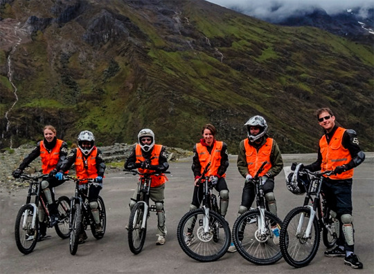
Cycling during the Inca Jungle
The first sport that is performed in the Inca Jungle is cycling. This tour begins at the highest point of the journey in the Abra Málaga (4,230 masl / 13,877 ft).
From there you descend in the company of an expert guide for 2 or 3 hours until you reach the town of Santa María.
Cycling is included in all tours to the Inca Jungle.
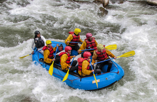
Canoeing during the Inca Jungle
Boating is an optional sport during the Inca Jungle.
It is carried out in the waters of the Vilcanota river in the company of an expert guide.
The difficulty of the adventure depends on the time of year.
Between April to October, the waters are suitable for exciting low-risk tours.
Between November to March, the river is only suitable for boating experts.
Trekking to Machu Picchu in the Inca Jungle
At various points of the Inca Jungle walks are made.
The trek from Santa María to Santa Teresa covers ancient Inca trails.
The section from Santa Teresa to Aguas Calientes, crosses one of the most incredible landscapes before reaching Machu Picchu.
The Cocalmayo thermal baths are an optional stop during the Inca Jungle.
The pools are outdoors and have a temperature of up to 44ºC.
This section is an opportunity to relax after several hours of walking.
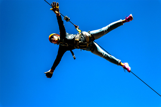
Zip Line during the Inca Jungle
This extreme sport is one more option during the Inca Jungle.
It takes place in the town of Santa Teresa, at the beginning of the third day.
The experience is doubly incredible due to the beauty of the landscape.
Then, the visitors meet the group to continue the trip to Machu Picchu.
Tours to the Inca Jungle: everything you need to know Is the Inca Jungle dangerous?
The Inca Jungle is a safe adventure.
The tour is carried out in the company of a professional tour guide trained in solving emergency situations.
What does the Inca Jungle tour include?
In general, an Inca Jungle tour includes the following:
Transportation to the ‘Abra Málaga’.
Professional guide throughout the tour.
Bicycle and safety implement.
3 nights of lodging (in Santa María, Santa Teresa and Aguas Calientes).
Food during the tour (breakfast, lunch and dinner).
Entrance to Machu Picchu.
Transportation by train from Aguas Calientes to Ollantaytambo.
Transportation by bus from Ollantaytambo to Cusco.
Optional services in the Inca Jungle:
Entrance to the Cocalmayo Thermal Baths.
Boating service and its implements.
Zip line service and its implements.
Transportation by bus (from Aguas Calientes to Machu Picchu and vice versa).
How to reserve the Inca Jungle?
Inca Jungle reservations are made at a tourism agency through the internet.
It is also possible to buy the tour directly from a tourism agency located in the Historic Center of Cusco.
Is the Inca Jungle difficult?
The Inca Jungle has a moderate difficulty. Adventure sports do not require significant physical effort.
In total, approximately 35 kilometers of trekking are traveled on easy routes of great scenic beauty.
How much does the Inca Jungle cost?
The Inca Jungle has an approximate cost of 300 U $ D. However, this price varies according to the tourism agency and the quality of the service they provide.
When is the best time to do the Inca Jungle?
The best time to do the Inca Jungle at Machu Picchu is in the dry season (from April to October).
During those months, the days are sunnier, the colder nights and the rains are unusual. Those days are ideal for outdoor excursions.
What to bring to the Inca Jungle?
It is recommended to take the following to the Inca Jungle tour:
Cap or hat.
Sunscreen.
Mosquito repellent.
Trekking shoes.
Canteen with water.
Cotton clothes for 4 days.
Rain poncho (in case of precipitation).
Bathing suit and towel (for the Cocalmayo thermal baths).
Trekking backpack.
Extra cash (in case you need it).
Photographic camera.
Tips during the Inca Jungle The Inca Jungle at Machu Picchu is one of the most incredible experiences in Peru. To fully enjoy this adventure it is recommended to consider the following:
The Inca Jungle is recommended for young people of any nationality. However, there are cases of adults with advanced age who want to do this adventure.
The Inca Jungle does not travel places that can cause soroche (altitude sickness). However, it is recommended to acclimatize at least 1 day in the city of Cusco before starting the tour.
Not in good physical shape? The Inca Jungle is not difficult. It is recommended to prepare physically at least only 1 week before the tour.
Don't feel ready for extreme sports? Many sports in the Inca Jungle are only optional.
Do you want to do the Inca Jungle with your group of friends or family? There are private tours. You only have to request it at the tourism agency of your choice.
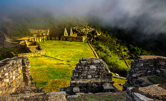
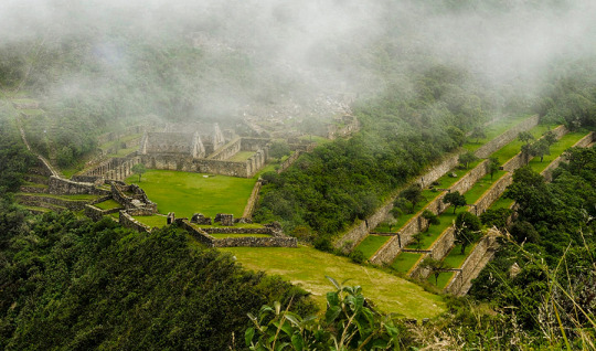
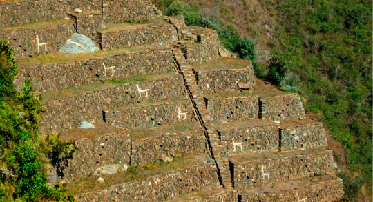
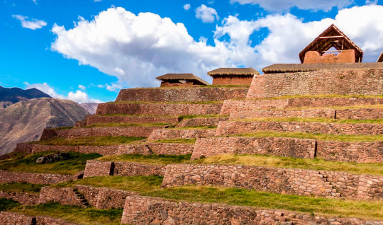
Choquequirao known as the sacred sister of Machu Picchu because it has a structural and architectural similarity, archaeological monuments are made up of terraces distributed on different levels which were leveled and fenced with stones to form a platform with an approximate area of 150 square meters. CHOQUEQUIRAO TREK INFORMATION
Location
The Choquequirao ruins are located at 13 ° 32 ’latitude and 77 ° 44’ west longitude, it is located at 3033 masl in the mountains of the snowy Salkantay north of the Apurímac river in the district of Santa Teresa province of the department of Cusco.
How to get
Currently to reach the last Inca fortress is the land route, the best known route of how to get to Choquequirao is by taking the road to Abancay, and at km 154 choose the detour that will direct you to the town of Cachora.
The route to Choquequirao has narrow paths which must be walked very carefully, also have a good physical condition and the proper equipment for this trek.
Weather
Due to its height, Choquequirao enjoys a temperate climate. However, it should be noted that the Choquequirao path is warm due to the Apurímac canyon.
Description
Choquequirao (comes from the Aymara words chuqui, gold, and from Quechua k'iraw, cradle, that is to say: "cradle of gold"), is another of the archaeological zones also known as the Inca citadel, it is located between the ramifications of the Nevado de Salcantay, southern Peru. These archaeological remains of Choquequirao are made up of a set of buildings and terraces distributed on different levels, from the lower Sunch'u Pata level to the highest truncated summit, which was leveled and fenced with stones to form a platform with an area approximately 150 square meters.
Choquequirao (sometimes also referred to as Choqequirau or Choquekiraw), is also known as the "sacred sister" of Machu Picchu for the structural and architectural similarities presented with it. Well, not too long ago it became known about this majestic place, thus awakening the interest of many tourists and researchers.
Biodiversity
The environment of Choquequirao is one of the richest in biodiversity, biologists, ecologists and experts mention this, however in this area, the number of species of plants and animals that exist is not known exactly, despite this deficiency and From the few scientific studies carried out, it has been possible to determine the existence of various life forms.
Among the most relevant species are: the condor, the fox, the skunk, the puma, the spectacled bear, the taruca, the vizcachas, the pica pica, the tall toucan, the quetzales and the tigrillos. All these species have been conditioned despite the temperature variations such as the sun throughout the day and the inclement frosts at night. This space can also be seen to the cock of the rocks, Peru's national bird.
The flora of the place is made up of giant ferns and a great variety of orchids, where the wakanki variety stands out. At the bottom of the great valley and under the thermal effect of the water course that runs through it, the forests of the mountain eyebrow provide their warmth and ideal conditions for a huge variety of crops of coca, annatto, corn, cocoa, coffee and fruit trees.
From the environmental point of view, the main value of these presented ecosystems resides in the role played by the exuberant forests that grow in the high parts of the mountains for the maintenance of the water balance of the region, capturing the rainwater and leading it without causing erosion towards the Apurimac River. MORE INFORMATION OF CHOQUEQUIRAO TREK TO MACHU PICCHU
This ancient Inca city is known as the younger sister of the Wonder of the World. Some tourists who made the 2-day hike to visit it even say that Choquequirao is better. It is true? Learn the truth about this new archaeological site in Cusco, Peru. CHOQUEQUIRAO TREK ITINERARY
What is Choquequirao really?
Choquequirao is an Inca urban center with features common to others in Cusco, especially Machu Picchu.
The similarity with Machu Picchu is largely due to the similarity of the geography of the place where the enclosure was built.
According to various investigations, Choquequirao would also be a fortress and a ceremonial center. The truth is that due to its hidden location in a high and distant mountain; It was a strategic point for various purposes.
Over the years, like Machu Picchu, Choquequirao was abandoned and covered by the jungle until its re-discovery.
Is it worth visiting Choquequirao?
The only way to get to Choquequirao is on foot. There are 3 days of roads (round trip) including the tour of Choquequirao.
The trek to Choquequirao makes visiting this inaccessible place a difficult but memorable adventure.
Once in Choquequirao, the tourist will be practically alone with an archaeological site as spectacular as Machu Picchu.
The few tourists in the world who visited Choquequirao agree that it was worth it.
Where is Choquequirao located?
Choquequirao is located at 3,103 meters above sea level. in a privileged location: it lies on the impressive canyon of the Urubamba river.
It is located in the foothills of the snowy Salkantay, in the Apurímac valley, in the province of the Convention in Cusco, Peru.
What does Choquequirao mean?
Choquequirao means ‘Cradle of Gold’ in Quechua. It is considered the ‘Sister city of Machu Picchu’, due to its similarities to the Inca City.
In truth, its architecture is as impressive as that of Machu Picchu.
At the moment Choquequirao has the advantage of not receiving the number of visitors that its "older sister" receives.
Few people know Choquequirao. Perhaps due to the difficult walk it takes to get there.
What is the architecture like in Choquequirao?
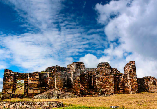
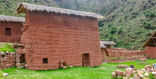
Choquequirao has numerous Inca buildings. However, currently only 30% of its entire area has been excavated.
Its most important buildings are quartzite, cut in great detail. The rest of the walls are made of raw stone.
These walls were covered with clay both inside and outside.
The Choquequirao walls are believed to have been painted light orange. Although in reality there are few structures that continue with this coating. CHOQUEQUIRAO TREK ROUTE
Andes (South America)
Vilcanota mountain range (Andes), in Peru, with an altitude of 6,372 m above sea level. It is located about 100 kilometers southeast of the city of Cusco. AUSANGATE TREK INFORMATION
Basic information
Relief unit: Andes
Country: Peru (South America)
Main summit
Region: Peruvian Andes
Altitude: 6,372 m
Latitude: 13 ° 47 '18' 'S
Longitude: 71 ° 13 '40' 'O
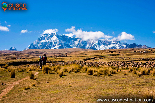
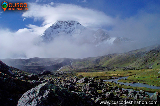
Every year, hundreds of mountaineers visit the Andean region of Peru. However, not many are aware of the existence of Ausangate, one of the Inca divinities of 6,410 meters high.
Located near Cusco, the "mountain of seven colors" is the fifth highest peak in Peru. Its remote existence from traditional routes means that few tourists approach its walls and glaciers; However, it is worth visiting for its unmatched beauty.
During the Inca Empire, Ausangate embodied one of its most important divinities. Distinction that still lasts; since, the inhabitants who live in the surroundings continue to consider her as an unreachable and sacred god.
The moderate difficulty of ascending the mountain and the possibility of living a unique experience outdoors, make visiting Ausangate a relevant option.
How to get?. Ausangate is located about 100 kilometers southeast of the city of Cusco. Leaving the city by car, the estimated travel time is 3 hours. Upon arrival in Chilca, you have to continue walking for another 3 hours, approximately, until you arrive at this formidable mountain of colors.
For tourists who do not have their own vehicle, there is the possibility of hiring a tour from the city of Cusco, or renting a private vehicle from Thrifty, one of the leading companies in the business.
Ausangate is the representative mountain of the Andes of Cusco and Peru. It is located in the Vilcanota mountain range and is one of the most difficult areas to enter and that is very rare in Peru. Its main climate is 6,372 meters above sea level with large lagoons with a bright green / blue color. In addition there are rocks that make the area like a paradise and very modern. The Trek Ausangate is an indescribable adventure, and it is impossible not to be impressed by the enormous beauty of eternal snow. Often you will find stones at a height of more than 5000 meters and also rocks covered with ice tongues that when thawing, extending in magnificent ways forming ice lagoons. The Ausangate trek is one of the tourist destinations in Cusco. AUSANGATE TREK INFORMATION
In the Inca mythology of this mountain and the nearby lakes - among which Sibinacocha stands out - the male energy is born that fertilizes the mother earth Pachamama, after a long flow, the waters are lost in the unknown lands of the Amazon to return, to fill the lakes and glaciers every night turned into the river of stars or Willkamayu known in the west as the Milky Way The Community of Chillca made up of shepherds of llamas and alpacas is known as the guardian of these pristine places, from where it can be done mountain walks spending the night in comfortable hostels or tambos, among which Machuracay Tambo stand out, in a trek called "Camino del Apu Ausangate".
Every year on the north side of Ausangate the feast of Quyllur Rit'i (Quechua: "star snow") is celebrated before the feast of Corpus Christi, during which thousands of Quechua pilgrims to the Lord of Quyllur Rit'i in the church from Sinakara. Snowy Ausangate normally takes a 7-day tour, it is an adventure that no one should miss.
The Nevado Ausangate is a natural attraction that is located in the Ocongate district, within the Quispicanchi province, in the department of Cusco. That snow-capped mountain is part of the Vilcanota Mountain Range and, according to an ancient legend, was the brother of the snow-capped mountain of Salkantay.
Nevado Ausangate, has a height of 6,384 meters above sea level; and it is considered an apu, or protective deity of the towns that surround it; as well as the most representative mountain in the region. Its size is such that it can be appreciated even if one is in the Sacsayhuamán Fortress, not in vain is it considered the fifth highest mountain found in Peru.
This beautiful snowy Cusco, impresses the eye, for its incredible natural formations; in that one not only are beautiful mirrors of water like the Sivinicocha, of turquoise waters, but also forests of stones, glaciers and high plains that seem to make this natural attraction a paradise on earth, especially for those tourists who are interested for adventure sports since the geographical features of Ausangate make it ideal for practicing sports such as rock climbing, ice climbing, trekking, among other activities.
The Nevado Ausangate is presented before our eyes as a mountain challenge; It is known that the first attempts to ascend it took place at the beginning of the fifties of the last century, there were two the first unsuccessful attempts to conquer the top of the powerful Apu, it was not until 1953, when a German expedition achieved the goal, Climbing the mountain on its southern slope, in posterity, new routes were opened for the conquest of the Apu, however, only in 1983, thirty years after the first ascent, Peruvian feet crowned the top of the majestic snow-capped mountain. AUSANGATE TREK ROUTES CUSCO - PERU
Huchuy Qosqo is located in the peasant community of the same name, just under 5 km from the city of Calca in the department of Cusco, in the Sacred Valley of the Incas; exactly at a summit at 570 m. over the Urubamba river basin (Vilcanota). The Huchuy Qosqo route is very beautiful; walking its trails will allow you to visit some Andean communities, archaeological centers and enjoy beautiful landscapes. Many people take advantage of visiting Huchuy Qosqo on their trip to Machu Picchu. HUCHUY QOSQO TREK TO MACHU PICCHU
What does Huchuy Qosqo mean?
Huchuy Qosqo means "Little Cusco", but it also has other names; one would be Qaqyaxaqixawana and the other Qaqyaqhawana, this means "from where the rays are observed"; and without a doubt it is a good name since being 800 meters above the Sacred Valley of the Incas, gives you the opportunity to see the dramatic light and sound show, at the moment when lightning and thunder descend from the sky to crash into the ground. Others say that the site was probably known in Inca times as "Caquia Jaquijahuana".
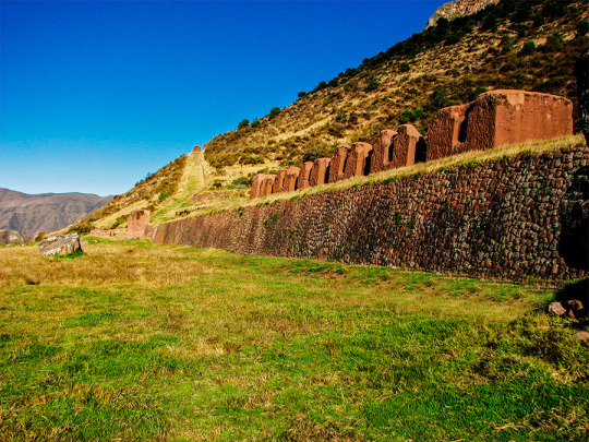
Huchuy Qosqo Archaeological Complex (Qaqyaqawana)
The compound located in Huchuy Qosqo, is called Qaqyaqawana; Quechua name that refers to the place where the lightning is seen. This archaeological site is located in the upper third of the mountain called Qaqya (thunder), and exhibits one of the most impressive topographical modification works through the use of andenería, modulating the edges of precipices and vertical ravines over the Vilcanota Valley, culminating on platforms that were used as ceremonial esplanades, around which several architectural structures made of stone and adobe can still be found standing. Materials used and worked with great judgment, achieving a fine finish.
In addition, the structures of the enclosure are distributed in such a way that they architecturally resemble the city of Cusco; it is for this reason that at the beginning of the 20th century it receives the name of Huchuy Qosqo (small Cusco). One of the most outstanding characteristics of this archaeological site is the use of lithic material combined with adobe and clay. This shows the knowledge and mastery of the different construction materials, used with high technology, especially adobe; The centuries-old walls built of this material still defy the strong inclement weather of the area, seismic movements and of course the passage of time.
INFORMATION OF HUCHUY QOSQO TREK
This complex is the most important archaeological center in the Urubamba valley, after Ollantaytambo and Pisac. The ruins are impressive, although the conservation of the site is inferior to that of Ollantaytambo or Pisac, because they are older.
But unlike the aforementioned places, Huchuy Qosqo has a peculiar architecture: the buildings have been built on polished stone bases with a fine finish, with clay plaster (they are the best preserved parts) and the highest floors are made of adobe. INFORMATION OF HUCHUY QOSQO TREK
A kallanka (rectangular enclosure that could measure up to 70 meters long and that were important state centers where Inca officials stayed) is observed, at least 40 to 50 meters long. Also a remarkable building with two stone floors and an upper one of adobe. There are also large terraces, a very large plaza and a large Inca gate through which a well-preserved path leads from Tambomachay.
The Hispanic chronicles refer that Huchuy Qosqo (probably a site known in Inca times as Caquia Jaquijahuana) was the work and preferred place of the Inca Wiracocha. To this, Maria Rostworoski adds, in her work "History of the Tahuantinsuyo", that this sovereign established the conquest over the towns of the Urubamba valley and that he chose as his successor his Inca son Urco who, dizzy with power and vices, proved to be totally incapable of ruling. Inca royalty was very confused by this choice and they tried to conspire to impose on another Wiracocha son, Prince Cusi Yupanqui. Social unrest and tension increased every day and to make matters worse, the darkest night fell on Cuzco: the Chancas reached the gates of the capital and were ready to destroy it. It is the year of 1438. Wiracocha abandons the city to his fate and, accompanied by his son Inca Urco, takes refuge in his palaces in the Urubamba Valley, among which was Huchuy Qosqo.
After the Spanish conquest, Gonzalo Pizarro found the mummy that supposedly belonged to the Inca Wiracocha here and ordered to burn it. The descendants of the Inca kept the ashes in a jar that many years later the chronicler Polo de Ondegardo would discover.
Characteristics of the visit
It is possible to visit Huchuy Qosqo in two ways, the first walking from Cusco and Tambomachay along the Inca trail. The other way is going up from the Sacred Valley after crossing the Wilcamayo river (today Vilcanota).