You can visit the architectural complex Choquequirao is situated in Vilcabamba at 3100 meters, considered the last Inka refuge and place of resistance from the invaders, when doing ....
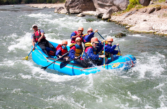
Our Inca Jungle Trail classic To Machu Picchu combines adventure sports such as mountain biking, rafting, zip line, hot spring and trekking for 4 days until you reach Machu Picchu....
In the upper area close to the Skies, the Incas built one of their best-preserved cities, now recognized as one of the 7 wonders of the modern world. Many travelers and adventurers come....
According to the research, the coloration of the rainbow mountain is due to the composition of minerals that it has: the pink color is for the red clay, fangolitas and arilitas. The whitish, for the quartzose ...
Showing posts with label travel to machu travelñ picchu. Show all posts
Showing posts with label travel to machu travelñ picchu. Show all posts
When one goes to the Lares Valley, one is impressed since this trip is very beautiful for the eyes, due to its mountains, its landscape, its gorges, its spectacular sky, the people and its clothing, particularly one is amazed.
The Lares valley is located in the Sacred Valley of the Incas, on the way to Machu Picchu, making a detour in the town of Calca to start the trip to the Lares valley, in Calca one can stop to buy provisions, with water , cookies and fruit, you can also enjoy a delicious breakfast in the main market of the town of Calca, it is recommended to leave early
Lares has allowed to maintain the nuance of its Andean people even though it is located at a distance not too far from the Sacred Valley, this valley is very pleasant for walks, experiential tourism, and a dip in its hot springs as well as the baths Machu Picchu hot springs, if you do the Lares trek it is normally 4 days, including Machupicchu this is the most common thing that travelers do.
The thermal baths in the Lares valley, said baths have a separate mention since the one who goes to Lares goes to the thermal baths, I am baths are medicinal and relaxing and are characterized by their color and smell, the yellowish color and a sulfur smell since these waters probably come from a volcano, particularly it is not known exactly where they come from, the thermal baths of Lares are very hygienic and are contained in pools made of very well treated stones, these pools are cleaned daily and They maintain a cleanliness at the height of the visitor.
This route offers a unique experience, an tourism route that gives us an unforgettable experience in the heights of the Sacred Valley. In the Lares Valley besides enjoying beautiful scenery you can enjoy a beautiful experience living with the local people, who will receive us with open arms showing the most beautiful thing about this place ... its "simplicity". On this route you can also enjoy the medicinal thermal baths, appreciate andean lagoons, snow-covered mountain passes and finally visit the Inca citadel of Machu Picchu.
Useful Information
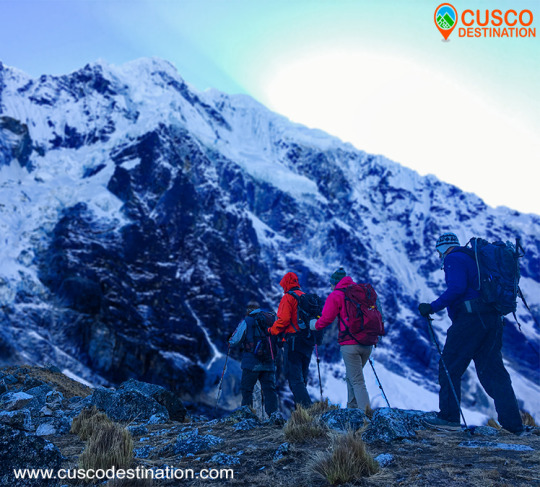
- Starting Altitude - 2900m / 11151ft. - Highest Altitude - 4780m / 15,682 ft - Walking Distance - 34 km / 21 miles - Longest Day - Day 1, approximately 14km / 8.7 miles - Overall Difficulty - Moderate - Difficult
IMPORTANT INFORMATION:
In the thermal baths of Lares there are 6 large swimming pools at different temperatures between 36 and 44 °C, you can choose to relax quietly, they are ideal for treating bone and gastrointestinal diseases.
Lares is surrounded by a mountain range that includes the Nevado Veronica (5900m high), the Sawasiray (5700m high), the Pitusiray and Chicon (5500m high). Small communities of Quechua-speaking farmers inhabit this recently-explored territory, who preserve their customs of herding llamas and alpacas, potato cultivation and textile production.
The recommended dates for traveling are the months from April to November with no rain in these months the climate is sunny, with a blue sky all day.
Machu Picchu is one of the 7 Wonders of the Modern World, Heritage of Humanity, Historical Sanctuary of Peru and probably the most important archaeological site in Latin America.
Machu Picchu is majestic architecture comprises 140 structures throughout the citadel.
Machu Picchu is was built by the Inca Pachacutec around the year 1460
After being forgotten, it was only in 1911 that the American Hiram Bingham reached Machu Picchu on an expedition and spread the site worldwide.
Brief Itinerary - Day 1: Cusco – Sacred Valley – Huaran – Cancha Cancha – Acopata - Day 2: Acopata – Pachacutec Pass – Quishuarani - Day 3: Quishuarani – Cuncani – Lares Hot spring – Ollantaytambo – Aguas Calientes - Day 4: Machu Picchu - Cusco
Day 1: Cusco – Sacred Valley – Huaran – Cancha Cancha – Acopata
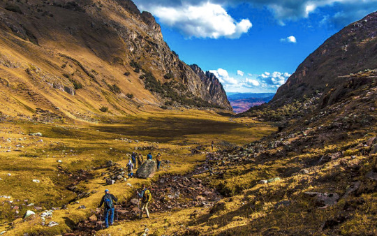
We will pick you up early from your hotel to take you to the beginning of the hike at Huaran (3,000 m/9,840 ft). The trail climbs gently following the Cancha Cancha river towards the community of the same name. On this walk along the river we will see cultivated fields and pass through old qiwiña (Polylepis) forests. This type of vegetation is very interesting and the valley itself is very impressive. We will have lunch half way through the hike. We will pass by the village of Cancha Cancha (3,956 m/12,976 ft). on the way to our camp. this day we will walk 6 hours to our camp in Acopata.
Day 2: Acopata – Pachacutec Pass – Quishuarani
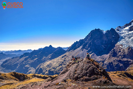
After our breakfast we will continue with our hike up hill, for 3 hours, then we will reach the highest point of the trek, Pachacutec Pass (4,780 m/15,678 ft.). The landscape from here is wonderful. The Pitusiray and Sahuasiray snowcapped mountains will be right in front of us.
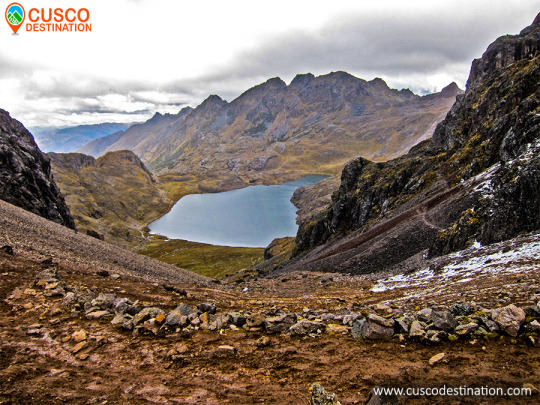
After we will hike downhill for 2 hours until we reach our lunch spot, next to a captivating lake.
After Our lunch we will descend for another 2 hours into the valley. We will pass by several glacial lakes along the way. Also we can see herds of alpacas, llamas and sheep. It is also possible to see Gray Brocket Deer, Viscachas, Andean Geese, the rare Giant Coot, Puna Hawks and the impressive Andean Condor. Tonight we camp at 3,870 m/12,694 ft close to Quishuarani village, which has typical stone houses
Day 3: Quishuarani – Cuncani – Lares Hot spring – Ollantaytambo – Aguas Calientes
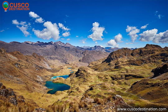
After Our Breakfast, we walk another valley and climb up to the second pass at Willcaccasa mountain (4,458 m/14,622 ft) , for 3 hours. Again the landscape of the Andes, turquoise lakes and its beautiful valleys are impressive.
After the pass we will walk downhill for 2 hours, passing many awesome lakes. This takes us to Cuncani village (3,900 m/12,792 ft).
We then continue downhill for 3 hours towards the Lares Valley and its hot springs, where we can have a well deserved soak. This is also our lunch spot.
Then that we are fully relaxed, we will get in our private van, which will be waiting for us, for the 3 hour drive to Ollantaytambo (2,792 m/9,158 ft). We will have dinner in Ollantaytambo. After dinner, we will take the train to Aguas Calientes. We’ll spend the night there before climbing the Inca citadel of Machu Picchu.
Day 4: Machu Picchu - Cusco
After an early breakfast at the hotel, we walk uphill to Machu Picchu at 5:00 am. or take the bus from Aguas Calientes to Machu Picchu (Optional bus $16 each way), upon arrival at the Citadel we can appreciate the enigmatic beauty and the incomparable example of architectural perfection and hydraulics of one of the 7 Wonders of the Modern World, we will have a guided tour of about 2 hours, where we can appreciate the Main Plaza, the Circular Tower, Intihuatana, The Royal Quarters, the Temple of the Three Windows and the Cemetery, you are then given free time to stroll around the citadel . You will have all morning in Machu Picchu to take pictures, maybe to climb the Wayna Picchu or Machu Picchu Mountain, enjoy this mystical place. Then we´ll descend by bus to Aguas Calientes for lunch and then calmly return by train to Ollantaytambo where our tourist transport to the city of Cusco will be expecting us, and will later transfer you to your hotel. OTHER ACTIVITIES:
Climb up Huayna Picchu and appreciate the beauty and magnificence of Machu Picchu from there (We recommend that you book in advance) Not Included
Climb Machu Picchu Mountain and appreciate the beauty and magnificence of Machu Picchu from there (We recommend that you book in advance) Not Included
Visit the new local museum or the hot springs in Aguas Calientes later in the day. Not Included
- Meals: Breakfast - Tour: 2 hour guided tour of Machu Picchu MORE INFORMATION OF LARES TREK TO MACHU PICCHU
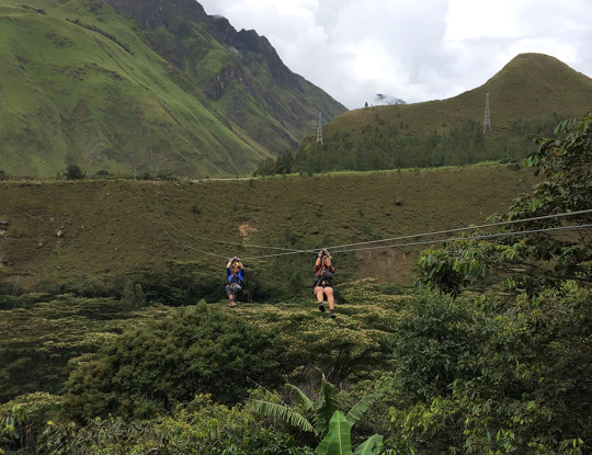
Our Inca Jungle Short is a quick way to combines adventure sports such as mountain biking, river rafting, zip line and trek for 3 days until you reach Machu Picchu.
The Inca Jungle Trail Short combines adventure sports such as mountain biking, rafting, zip line and trekking for 3 days until you reach Machu Picchu and one of the additional mountains "Machu Picchu Mountain" or "Huaynapicchu". The Inka Jungle Trail is the favorite tour for young people from all over the world who come to Cusco in search of adventure and extreme sports. As a Tourism Agency located in Cusco we offer a differentiated service; with an exclusive route, trained guides (real command of English and local history), bicycles equipped for downhill, the safest rafting and zipline services. We recommend our passengers book in advance to have everything insured and avoid unnecessary risks such as loss of equipment, lack of access to Machu Picchu, Machu Picchu Mountain, Huayna Picchu or even worse, being stranded in Aguas Calientes (no return train).
The Abra Malaga is a mountain pass that lies between the town of Ollantaytambo and Quillabamba, through unique Andean ecosystems. This path contains two types of well-defined areas: The Abra (4,297 m) and the lower part (Carrizales 3,245 m). The birds that you’ll observe are rare and highly sought after.
In Santa Teresa there are thermal baths: Cocalmayo, composed of 3 pools of different sizes, temperatures and depth. You can also do adventure sports like rafting, kayaking and zip line
Machu Picchu is one of the 7 Wonders of the Modern World, Heritage of Humanity, Historical Sanctuary of Peru and probably the most important archaeological site in Latin America.
Machu Picchu is majestic architecture comprises 140 structures throughout the citadel.
Machu Picchu is was built by the Inca Pachacutec around the year 1460
After being forgotten, it was only in 1911 that the American Hiram Bingham reached Machu Picchu on an expedition and spread the site worldwide. Brief Itinerary - DAY 1: CUSCO – SANTA MARIA – SANTA TERESA (BIKING) - DAY 2: SANTA TERESA – AGUAS CALIENTES (TREKKING) - DAY 3: MACHU PICCHU - CUSCO
DAY 1: CUSCO – SANTA MARIA – SANTA TERESA (BIKING)
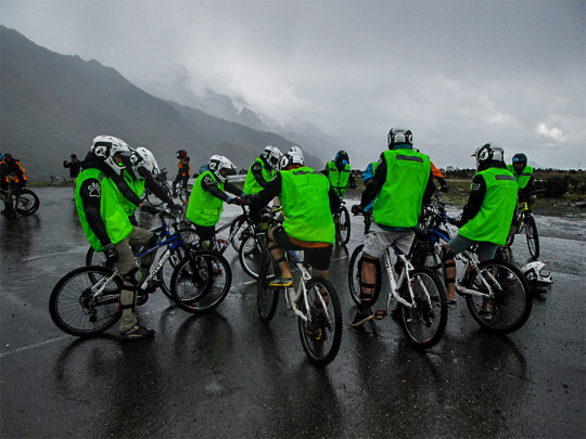
we will pick you up between 6:00 to 6.30 am, then we will leave the city seeing beautiful natural surroundings of Sacred Valley at about 2700 m.a.s.l. Arriving at the town of ollantaytambo we start the 46 km. uphill to the abra malaga (Mountain Pass at 4350 m.a.s.l.) approx. Here, we will change the biking kit provided (gloves and helmet) and receive a 20-minute briefing by our tour guide. After, start our descent by bicycle, passing by little rustic villages, fruit groves and streams arriving at the small village of Santa Maria, we’ll traverse the pass by bike toward wamanmarca (3 hours. After the bike ride, we’ll take a mini-bus to of Santa Maria – Santa Teresa. In Santa Teresa, you can enjoy the hot springs (Lunch, Dinner, Hostal). Optional activity: rafting that will take two hours to do it (level of rapids depends of the season) $35 extra dollars.
- Shuttle to Abra Malaga: 3.5 hour by bus from Cusco - Biking distance: 65km 40mi - Biking time: 3.5 to 4 hour approximately. - Climate: cold at the beginning of the biking and very hot in the night. - Optional Rafting Tour in Santa Maria, US$35 Pay Directly To The Operator - Maximum Altitude: 4350 meters / 14271 ft. - Minimum Altitude: 1250 meters / 4691 ft.
DAY 2: SANTA TERESA – AGUAS CALIENTES (TREKKING)
After breakfast we will continue our Adventure to the Hydroelectric (power plant), This part of the trek is called the waterfall day where we’ll pass many cascades. In Hydroelectric we will enjoy of a great lunch. And after a break we will continue walking along this great inca jungle tour for 3 hrs., enjoying beautiful waterfalls, going through coca and coffee farms along the railway until arriving at the town of Aguas Calientes around4 pm. Here the group will spend the night in a hostel. Optional activity: ZipLine before you get to the Hydroelectric US $ 30 extra dollars.
- Hiking distance: 19 Kilometers / 12.3 mile
- Climate: hot in the day and warm in the night. - Optional Zipline Tour in Santa Teresa, US$30 - Hiking time: 6 hour approximately. - Maximum Altitude: 2050 meters / 6725 ft. - Minimum Altitude: 1430 meters / 4691 ft. DAY 3: MACHU PICCHU - CUSCO
After an early breakfast at the hotel, we walk uphill to Machu Picchu at 5:00 am. or take the bus from Aguas Calientes to Machu Picchu (Optional bus $16 each way), upon arrival at the Citadel we can appreciate the enigmatic beauty and the incomparable example of architectural perfection and hydraulics of one of the 7 Wonders of the Modern World, we will have a guided tour of about 2 hours, where we can appreciate the Main Plaza, the Circular Tower, Intihuatana, The Royal Quarters, the Temple of the Three Windows and the Cemetery, you are then given free time to stroll around the citadel . You will have all morning in Machu Picchu to take pictures, maybe to climb the Wayna Picchu or Machu Picchu Mountain, enjoy this mystical place. Then we´ll descend by bus to Aguas Calientes for lunch and then calmly return by train to Ollantaytambo where our tourist transport to the city of Cusco will be expecting us, and will later transfer you to your hotel. OTHER ACTIVITIES: Climb up Huayna Picchu and appreciate the beauty and magnificence of Machu Picchu from there (We recommend that you book in advance) Not Included Climb Machu Picchu Mountain and appreciate the beauty and magnificence of Machu Picchu from there (We recommend that you book in advance) Not Included Visit the new local museum or the hot springs in Aguas Calientes later in the day. Not Included
- Meals: Breakfast - Tour: 2 hour guided tour of Machu Picchu INCA JUNGLE TRAIL INFORMATION.
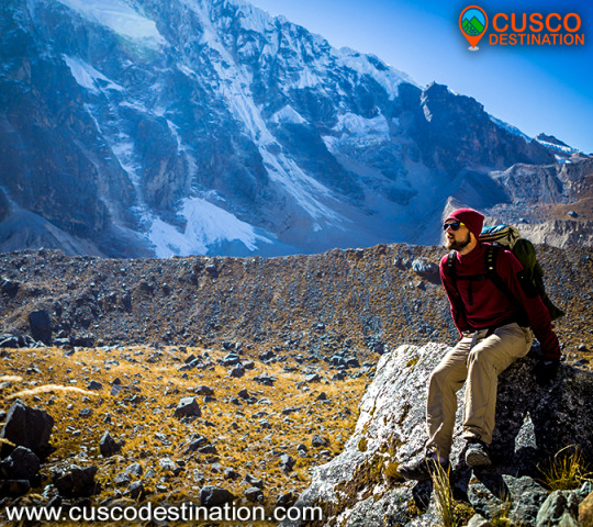
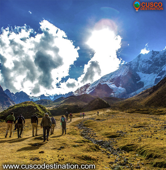
The Salkantay Route, also known as the “New Inca Trail”, is located north of the city of Cusco, following the Cusco - Limatambo - Abancay - Lima road, making a detour between Limatambo and Mollepata.
Salkantay snowy climate:
It is very sunny during the day, but cold at night. The temperature drops below 0 ° C at night during the months of June to September. In the season from December to March it is very rainy so it is not recommended to go on these dates.
The best time to do this trek is during the months of March to September.
This hike reaches a height of 4,600 meters above sea level at its highest point is on the slopes of the same snowy Salkantay. Enter Ausangate 5D Snowy Walk to do this little walk.
How to get to the snowy mountain of Salkantay
The buses from Cusco to Mollepata leave very early from 4 am to 5 am and pass through Limatambo, from Mollepata is where the trek to the snowy Salkantay begins, after climbing a step it is possible to have an impressive pyramidal view of Salkantay, one of the mountains most beautiful snowfall of Cusco.
From Mollepata it takes two days to descend to Huayllabamba and join the second day of the Inca Trail.
What you will see along the way
On the way you can see herds of cattle and sheep, orchids, bear with glasses, medicinal plants of the Inca eponca, small variety of birds, fruit trees such as orange, papaya, bananas, and so on. Note: The eye of the glasses to see it is necessary to have some luck.
recommendations
It is very important for the traveler. Bring your original passport for the respective controls.
RECOMMENDED MONTHS TO TRAVEL
March: (a little rain) From April to October: (an excellent trip) From October to November: (a little rain) December to February: (lots of rain) SALKANTAY TREK INFORMATION
Note: There is, in my opinion, a controversy regarding the paternity of the first ascent of this crest S.E., since it consists in the previous realization of a powerful group of Japanese who achieved the ascent by this route. Unfortunately, the only reference found in this Japanese ascension dates from an Iwa magazine to Yuki, written, of course, in Japanese, so without a translation of the text there is no concrete data.
Humantay Mountain - Salkantay Route To Machu Picchu
The western edge of the Salkantay is a route that remains virgin after years given the complexity of its layout and the distance from the traditional approach points, which requires additional porting based on the dragging of backpacks.
According to the prestigious Pyrenean Louis Audoubert, who ascended to the top by the northern slope in 1977, the west edge is feasible, but it will certainly be a good problem to solve at the Andean level.
This crest was attempted in 1975 by a group of Catalan climbers from Mataró formed by Manuel Punsola and Mitjans, Miquel Sala and Roy, Xavier Varela and Pinart, Ramón Armengol and Carbó, Antoni Sors and Farre, Antoni Rosa and Olivera and Vicente Aris and Julta .
On August 5, 1975, three members of this expedition approached the edge by an additional buttress of the northern slope that had been previously recognized. They go up for a good part of the day until they reach a point with two possibilities that seem unattainable. The logic was to tackle the ice ridge, something impossible given the lack of material means. The other option would be to flank the slopes of the ridge to look for the hill between the two Salkantay peaks.
At a certain point of this great flanking, which they calculate, it will take them a whole day, they decide to leave due to the large number of avalanches that leave the ridge and that are obviously a first order objective danger. Catalan climbers believe that the difficulties so far have not been important or dangerous, but moving away from the obvious route of the ridge, which would require more human and material equipment, greatly increases the risk.
Coming from Mollepata the first vision we will have of Salkantay is in its overwhelming south face a huge wall that closes the bottom of the valley with its vertical seracs hanging from huge rocky spurs, this wall could not fail to attract the attention of those who try to complicate a little their lives for pure personal satisfaction, so in 1970 a powerful group of Germans from the Munich DAV composed of Walter Welsh, J.Vogt, H.Koebrich, H.Haver and M.Olzowy made a meritorious attempt on the left side of the wall, leaving quite high on the crest that descends to the western summit of Salkantay.
In 1986 an English group led by J.Lowe broke through this hillside attacking the rocky base to the right of the German attempt of the 1970s. The snow zone continued a slight diagonal to the right until it reached the eastern peak of the mountain.
On June 15, 1978, a powerful Slovenian expedition of the Planinska Zveza, composed of Libor Anderle, Zoran Breslin, Marjan Brisar, Edi Torkar, Jure Zvan and Jure Ulcar, accompanied by Dr. Borut Pirc and Matjaz Derzaj as coordinator, opened in a week Exploring and climbing an intelligent route along the eastern slope of the mountain, the Slovenian route, which without detracting from the difficulty, is the most feasible option of trying to reach the top.
The second ascent to this route was made by the Mexican Roberto Morales Puebla and companion on June 17, 1978 and the third by Los Vascos de San Sebastián, Iñígo and Jesús Mª Barandiarán, José Luís Conde and Jesús Mª Rodríguez accompanied by Alberto Cabezón and José Antonio Fernández de Aranguiz on July 3 of the same year, which makes it the first ascent of mountaineers in the Spanish State.
The Salkantay has been visited by mountaineers from around the world, French, Swiss, North American, New Zealander, Polish, Austrian, German, Mexican, Slovenian, Slovenian, Spanish (Asturian, Basque, Andalusian, Catalan)…. that have crossed its steep slopes… some lived the light of the reward from the top ... others, a great majority, had to withdraw when the chance of triumph among the cornices escaped. SALKANTAY TREK TO MACHU PICCHU INFORMATION
Also known as Salkantay, Peru's snowy peak located in the department of Cuzco, it is one of the main elevations of the Vilcabamba Range, an extension of the Eastern Cordillera, a mountainous branch of the Peruvian Andes. It reaches an altitude of 6,271 meters. It has two snowy peaks, known as China Salkantay and female Salkantay, separated by a port that opens to the Santa Ana Valley in the province of Urubamba. Both the mountain pass and the course of the river that is born there are called Salkantay. This river pours its waters into the Urubamba on its left bank.
Our company has the Salkantay Trek, a walk that will take you to Machu Picchu.
Hence the name of Snowy Salkantay:
The name of this mountain is a contraction that comes from Salga = sullen or wild and Antay produces bees or avalanches. It is usually preceded by the name of Apu, which in Quechua language comes to mean sir, is defined as large mountains that mean something sacred above the valleys. For example, Apu Salkantay in the Vilcabamba mountain range.
Snowy Salkantay (6,271) Source: Musical Henares, S.L. (Alcalá de Henares - Madrid)
The great white Apu. A little stories between ropes and crampons:
The Salkantay is one of the highest mountainous regions of the Qosco (Cusco). The highest mountain is the Gran Agusánate with 65 meters more in the Vilcanota mountain range located further south. However, and without a doubt, it is the greatest in its splendid isolation and in the greatness of its double-headed massif, to which is added the fact of being one of the mountains of this magnificent Andean region that presents greater technical problems for all its slopes This is evidenced by the six itineraries opened to date by the different slopes of this white giant.
His conquest dates from 1952 by the Swiss cordate composed of Bronimann and Marx.
This first ascent, like so many others in the history of mountaineering, is involved in several contradictions, since a few days later it is promoted again by a Franco-American expedition that included the well-known and relevant mountaineer of the Claude Kogan era.
Modern statistics merit being the first woman on top of the Italian Consuelo Bonaldi who climbed Cresta Este on August 4, 1978 accompanied by G.Marconi, A.Monononi, F.Nodari, S.Castellani, Augusto Zanotti and M.Quatrinni, obviously this is a mistake, since Claude Kogan did it 26 years before.
The Salkantay summit has two peaks, the East and the West, formerly the West, more slender and attractive than the East, which was slightly taller because it was crowned by a seracoa. After the passing of the years and the collapse of this serac, as the prestigious Pyrenean Louis Audoubert has pointed out, the height is practically identical in both peaks.
What happened in those two consecutive “first ascents” gave rise to the controversy that it had really been the first real one. The Swiss went up in the fog to the top of the East (the lowest in those days), the Americans however went up to the West, which was somewhat higher so the statistics, always relentless, want to deny Bronimman and Marx his first absolute ascension.
In 1953 he was climbed for the third time by the prestigious Alpine guide Lionel Terray, who together with the Dutch T. de Booy and the Swiss Raymond Jenny defeated the summit following a route along the northern ram, now known as the Terray Ram.
Years later, a German expedition tries the top following the dangerous crest of the N.E. which, with its cornices, does not favor traffic ... a relevant rope formed by Tony Mazenauer and Fritz Kasparrek (the latter conqueror of the north face of the Eiger) disappears on this ridge and the expedition has to be withdrawn.
Today there is a plaque commemorating that unfortunate event under the passage of Palcay (the usual base camp of the mountain) and on a block of visible rock.
On August 23, 1975, it was the turn of a long and steep crest of the S.E. of an Australian-New Zealand expedition composed of Peter Jennings, Wayne Barton and Michael Andrews. This ascent was the ninth to the top.
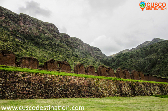
The quarry of Cachicata was the place of extraction of the stones that were used for the construction of Ollantaytambo and many surrounding areas. This place is 9 kilometers from the Inca town of Ollantaytambo and has three groups of quarries: Molle Pucro, Sirkusirkuyoc (it was the largest), shows evidence of having been in full operation when the Spaniards entered this area. And finally Kantirayoq or Cacchicata, where another type of extraction of minerals and precious stones was practiced.
- Starting Altitude - 3350 meters / 10990 feet . - Highest Altitude - 4500m / 14,764ft - Walking Distance - 25 km / 15.5 miles - Meals - 2 breakfast, 2 lunch, 2 dinner, 2 tea times, 2 wake up tea - Overall Difficulty - Moderate - STARTING POINT: - Cusco at your hotel
IMPORTANT INFORMATION:
The Community of Cachiccata consists of 80 families and a total of approximately 300 people.
The quarries of Cachiccata is one of the most important attractions, these quarries were widely exploited in the Inca period. From this mine they selected and transported the stones from the archaeological remains of Ollantaytambo. By means of own bearing and thrust techniques, the stones were transferred to this old center. On the way we can see giant semilabrated stones that were being transported. Near the quarries we can also visit some pre-Hispanic chullpas (ancient funerary tower).
Machu Picchu is one of the 7 Wonders of the Modern World, Heritage of Humanity, Historical Sanctuary of Peru and probably the most important archaeological site in Latin America.
Machu Picchu is majestic architecture comprises 140 structures throughout the citadel.
Machu Picchu is was built by the Inca Pachacutec around the year 1460
After being forgotten, it was only in 1911 that the American Hiram Bingham reached Machu Picchu on an expedition and spread the site worldwide.
Brief Itinerary
- DAY 1: CUSCO – PACHAR - SOQMA – CHARCAHUAYLLA - DAY 2: CHARCAHUAYLLA – INTI PUNKU – CACHICATA – OLLANTAYTAMBO – AGUAS CALIENTES - DAY 3: MACHU PICCHU - CUSCO
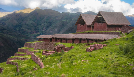
This complex is the most important archaeological center in the Urubamba Valley, after Ollantaytambo and Pisac. The ruins are impressive, although the conservation of the site is inferior to that of Ollantaytambo or Pisac, because they are older. But unlike the aforementioned places Huchuy Qosqo has a peculiar architecture: the buildings have been built on polished stone bases of fine finish, with clay plaster (they are the best preserved parts) and the highest floors are made of adobe.
Useful Information
- Starting Altitude - 3848 meters / 12624 feet. - Highest Altitude - 4150 meters / 13615 feet. - Walking Distance - 12 km / 7.46 miles - Overall Difficulty - Moderate - STARTING POINT: - Cusco at your hotel
IMPORTANT INFORMATION:
The Hispanic chronicles refer that Huchuy Qosqo (probably a place known in Inca times as Caquia Jaquijahuana) was the favorite work and place of the Inca Wiracocha. A kallanka of at least 40 to 50 meters long is observed. Also a remarkable building with two stone floors and one upper one of adobe. There are also large terraces, a very large square and a large Inca gate through which passes a very well preserved road that leads from Tambomachay.
Brief Itinerary - OPTION 1: CUSCO – TAUCA – HUCHUY QOSQO – CUSCO - OPTION 2: CUSCO - TAMBO MACHAY - PUCAMARCA - HUCHUY QOSQO - CUSCO HUCHUY QOSQO TREK INFORMATION
The Lares Valley is located between the eastern slopes of the Andes and the northern part of the Urubamba Mountain Range, it is a place with beautiful glacial lagoons and warm subtropical ravines, it also has a great variety of vegetation and wildlife. information of Lares Trek
It is surrounded by a mountain chain of the mountain range, where the snows of Verónica, Sawasiray, Pitusiray and Chicón are located. Small communities of Quechua-speaking farmers live here, who maintain their customs of grazing llamas and alpacas, growing tubers and producing tissues.
For all the above, this valley grants a great variety of tourist attractions. It is common for tourists to come to Lares to interact with local communities and learn more about their traditions, and it also gives the possibility of doing one of the best trekking routes in Cusco.
Location
It is located in the province of Calca, in the department of Cusco.
Climate and temperature
Between the months of May and October the area presents a sunny climate, with a temperature from 15 ° C to 21 ° C. From the months of November to April it is rainy season.
Altitude
It has a height of 3,170 masl.
How to get to Lares Valley
To get to Lares you can access by doing 2 routes. The first Cusco - Pisaq - Calca - Lares and the second Cusco - Chinchero - Urubamba - Calca - Lares. The road is in very good condition but it still takes time to reach the destination, it is advisable to hire the services of an agency to reach the Lares Valley.
Huch’uy Qosqo (Quechua: “Little Cuzco” also called Yuchuy Cuzco) is an archeological site 50 km north of Cusco, in Peru. It is located at an altitude of 3,600 meters, above the city of Lamay, in the district of Calca, province of Calca, in the Sacred Valley of the Incas.
The site was named in the twentieth century; He had previously been known as Kakya Qawani. Pedro de Cieza de León, in his Second Chronicle of Peru, said that the palaces were built by Viracocha, the eighth Inca ruler. Among a large number of buildings, some of stone, some of adobe, is a Kallanka (large hall) 40 m long. The water supply is an Inca built irrigation canal, filled with stones of about 800 meters.
Huchuy Qosqo was probably established as a royal estate by the Inca Emperor Viracocha around 1420 CE
The Spanish took control of Kakya Qawani in the year 1500, after the Inca Manco Revolution (approx. 1540) and the site is used as a farm. Villagers built several small reservoirs for irrigation. During their time in Huchuy Quosqo, the Spaniards demolished some other Inca structures to build the largest reservoir seen today.
Below the main site of Huch’uy Qusqu is the recently restored storehouse for meat and crops such as corn, potatoes, quinoa and dried beans. In this two-story structure, you can see the historic refrigeration storage system known as ‘conjeras’.
The settlement in the archeological ruin in Huchuy Qusqo dates back to between 1000 and 1400 CE. In the early 1400s, according to the Spanish chronicler Pedro Cieza de León, it became a real property of the semi-mythical Viracocha (c. 1410-1438), the eighth Inca ruler.
The Inca Empire did not impose the income or production of its citizens as a common practice, but rather controlled the land and labor. Thus, the Inca leaders acquired great real properties to increase their power and wealth and that of their descendants who inherited the properties. The royal properties also served as elegant rural palaces and sometimes fortresses to defend themselves against their rivals for power. Thus, the name Huchuy Qosqo, "Little Cusco", for a real property or government center modeled in the Inca capital.
To build, operate and maintain their assets, Viracocha and its descendants required a large number of workers. The citizens of the Inca empire were obliged, under the mit’a system, to contribute labor to the Empire, instead of paying taxes on their wealth or production. Mit'a impressed labor was probably found among nearby ethnic groups, although specialists and artisans could be imported.
Another Inca policy, that of mitma, was probably used to collect labor for the royal heritage. The mitmaqkuna were entire families or ethnic groups that moved to new lands in the empire or settled in enclaves among the first inhabitants of an area. The purpose was to widely distribute the different ethnic groups, thus separating potential troublemakers and reducing the possibility of organized resistance to the Incas. The mitmaqkuna were discouraged from mixing with local ethnic groups. A third source of work for the farm was the Yanakunas, the permanent servants of the Incas. The Yanakuna often reached high positions in the Empire, and as the mitma were ruled directly by the Incas. Still a fourth source of work for the royal states was aqllakuna, abducted women who lived together and produced textiles, an important source of Inca wealth, and chicha, the fermented drink consumed at parties. The Allakuna used to marry men honored for their service to the Empire.
These four sources provided the work and experience for the management of a real estate that could control thousands of acres of agricultural and grazing land, mines, textile factories and other resources and employ thousands of people. The sixteenth-century Spanish sources identify more than 40 ethnic groups found in an area of the Sacred Valley, an indication of the degree of resettlement and disruption of the population undertaken by the Incas during their reign.
Among a large number of buildings, some of stone, some of adobe, are a Kallanka (large hall), 40 m long. The water supply to the site is an irrigation canal built by the Incas, lined with stones for about 800 m.
Inca wall and agricultural terrace (anden). The Spanish took control of Huchuy Qosqo in the 1500s, after the Inca Revolution of Manco (approximately 1540) and used the site as a farm. The Incas had built several small reservoirs for irrigation. During their stay in Huchuy Qosqo, the Spanish demolished some other Inca structures to build the largest reservoir seen today.
Below the main site of Huchuy Qosqo are the recently restored qolqas stores for dried meats and crops such as corn, potatoes, quinoa and beans. In this two-story structure, you can see the historic refrigeration storage system known as "shells."
INFORMATION OF HUCHUY QOSQO TREK
This site is inaccessible by a public road and can only be accessed by a physically strenuous walk or on horseback. The two main access points on foot are from Lamay: 3 hours to a series of sharp curves, or from Tauca, Peru, about 4 to 6 hours on foot. The first third of the walk steadily increases up to a step at 4400 m, then mostly Descent, and visiting other ruins. The 2-day route from Tauca to Lamay is described in "Exploring Cusco" by Peter Frost. Several tour groups also take two-day walks or horse riding excursions to Huchuy Qosqo.
KNOW MORE -This route starts in Ccorao, where it deviates to Patabamba and then to Quenqo, where the seven-hour hike that ends in Lamay, in the Sacred Valley begins.
-The name of Huchuy Qosqo was put in 1930 by the intellectual from Cusco, José Gabriel Cosio; but the real name is Qacya Qawarina (‘where is the thunder’).
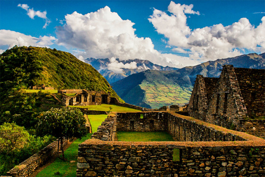
The Choquequirao fortress is located in the Vilcabamba area, where the Incas of the Manco dynasty resisted the Spanish conquerors for 36 years (1536 - 1572), who never managed to expel them from it.
The construction of Choquequirao is the work of the successors of the Inca Pachacútec, Túpac Inca Yupanqui (1471 - 1493) and Huayna Cápac (1493 - 1527). In the place, domestic and ceremonial ceramics of the classic Cuzco style were used, as well as others, typical of the population that moved to build and populate the site permanently, probably farmers experienced in building and exploiting agricultural platforms in eyebrow areas jungle.
Approximately 40% of the Inca ceremonial center of Choquequirao is free of vegetation and restoration and enhancement work is currently being carried out. The remaining area is formed by a complex system of platforms built on very steep slopes. A short time ago, an impressive 180-platform staircase has been located that descending from one of the flanks of the ceremonial center reaches the river, where it is possible to swim.
Choquequirao was possibly one of the entry control points to the Vilcabamba region, and as such an administrative nucleus with political, social and economic functions. In its urban conception it followed the symbolic patterns of the imperial capital with places of worship dedicated to the Sun, ancestors, land, water and other divinities, royal residences, houses of administrators and artisans, warehouses, large dormitory buildings or Kallancas and agricultural platforms of the Inca and the town. The ceremonial area extends over 700 meters, with a level difference of up to 65 meters between the main square and the highest parts. The complex consists of nine stone architectural groups and a system of 180 platforms, apart from the areas of residential, administrative, craftsman, irrigation system, among other buildings built on a stone base.
The sectors that are defined by the topography of the place had different functions and communicated through pedestrian access to the main square. You can see a complex hydraulic system probably designed for domestic, ceremonial and agricultural use.
Given the geographical location of Choquequirao, compared to other complexes of the same period, it seems that it had the function of being an Inca enclave towards the hot valleys of the Apurimac River. Its inhabitants dedicated to intensive agriculture and performed ceremonies where water was an important element of worship. In addition, it was a storage place for various products from other areas, as well as a connection between the valleys of Apurimac, Vilcabamba and Vilcanota.
Choquequirao is located on the border of the department of Apurímac and Cuzco, the archaeological site of Choquequirao was not built to be a place that is accessed as if in passing, and now reaching it demands two days of disciplined march, largely offset by beauty of the landscape that accompanies the walker from his first steps.
The journey begins in Cachora (2,800 m.a.s.l.), a small town in the department of Apurimac which is reached, having departed from Cuzco, after four hours of good road (145 km asphalted and 10 km affirmed). It is there where the mule muleteers are contacted, who also act as guides. A local family offers lodging and the only phone in the town.
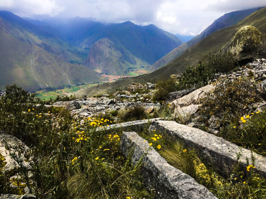
Walk to Choquequirao Currently the trek to Choquequirao (trekking) has become one of the best alternatives to the famous Inca Trail to Machu Picchu, with which it competes in scenic beauty and adventure. The traditional route is Cachora, Coca Masana, Rosalina Beach, Choquequirao, Raqaypata, Chikisca, Cachora. There are also walks that link Machu Picchu with Choquequirao. Normally the adventure begins in the city of Cuzco, on a road trip of 93 km (3h 30 'by car) to the town of Cachora at 2,300 meters above sea level, and from there a 30-kilometer walk starts in 4 or 5 days, with a total of 60 kilometers, crossing areas of abundant and varied vegetation and fauna from the high Andean zone to the jungle, crossing the Apurimac river canyon.
Tour operators offer the service of guides and porters and all the logistics required for the walk. More information of Choquequirao Trek