
The lost city of the Incas of Choquequirao was probably built in the fifteenth century, along with the city of Machu Picchu, during the administration of the Inca Pachacútec. However, this statement is contradicted by other historians who claim that its construction was later than Pachacútec, during the governments of Túpac Yupanqui or Huayna Cápac.
Choquequirao Trek Information
In the Inca era, Choquequirao was a very important cultural and religious center that served as a commercial enclave and waypoint to Vilcabamba and Machu Picchu.
During the Inca resistance to the Spanish invasion, Choquequirao was one of the last bastions of resistance and Inca refuge. But, at the fall of the great Inca culture, the Inca people of Choquequirao passed to the forgotten one, and the immeasurable jungle was responsible for hiding it for many centuries.
Just in the early 1800s, the first explorers began to explore the lost city of Choquequirao.
But, it was not until the end of the 1990s that intensive studies began and the restoration plan began.
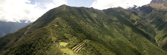
Currently, of the 1810 hectares comprising the Inca Llaque of Choquequirao, only 30% have been unearthed and put into operation as a tourist area. While 70% of the ruins still lie under the frond of the jungle eyebrow.
Structure
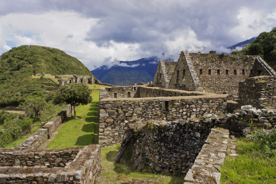
Unlike Machu Picchu, the Archaeological Ensemble of Choquequirao is a dispersed and varied settlement.Its architectural structure was built with edged stones and mud mortar, and is composed of:
- A ceremonial platform (Ushno).
- An upper square (Hanan) and a lower square (Hurin).
- Temples
- Niches
- Housing of the priests.
- Deposits and barns (Qolqas).
- Ditch network.
- And a platform system.
- Choquequirao sectors
Choquequirao is organized in 12 separate sectors (zones), whose paths converge to a large main square.
- Sector I. Located in the highest part, in the Hanan area. It includes an upper main square, buildings and an aqueduct that descends through successive stone fountains (phacchas).
- Sector II Located in the Hanan area, below sector I. It includes the Warehouses and warehouses (qolqas) and the “Giant Stairs” stairs of Bingham.
- Sector III It is the central nucleus of the citadel. It is located in the upper (hanan) and lower (hurin) sectors. It is made up of the main square or Hauqaypata, some annexed buildings of one and two levels (houses of the rulers and Kallankas).
- Sector IV Located in the Hurin or South zone, it is a main building composed of five covers that were probably used for ceremonial uses. In this place is the Temple of the triumphal wall and the sacred pens.
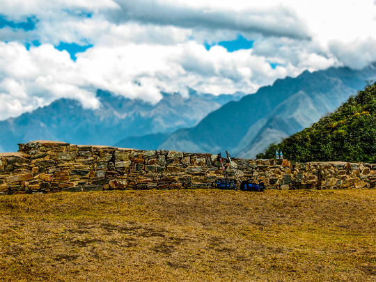
- Sector V (Ushnu). Located on top of a hill. It presents a ceremonial oval platform that is surrounded by a small wall. From this place you can see much of the archaeological park of Choquequirao, the mountain range of the Vilcanota Range and the great Apurimac canyon.
- Sector VI (Wasi Cancha). It is located south of the ushnu, in the lower part. Also known as temple and housing of priests.
- Sector VII. Formed by cultivation platforms on the east side (monumental platforms or sacred platforms), which stand out for hosting wide and wide platforms.
- Sector VIII. Made up of 80 platforms, divided into plots and water channels that descend from the main square. Here are the famous "platforms of the Flames of the Sun"
- Sector IX. Constituted by popular or family homes. It is better known as Pikiwasi.
- Sector X (Paraqtepata). Formed by 18 cultivation platforms and irrigation canals parallel to the stairs.
- Sector XI. Located in the area called Phaqchayoq, on the right bank of the Ch’unchumayo stream. It is composed of 80 wide platforms.
- Sector XII In this sector are the cultivation platforms. It is made up of 57 platforms with permanent irrigation.


0 comments:
Post a Comment