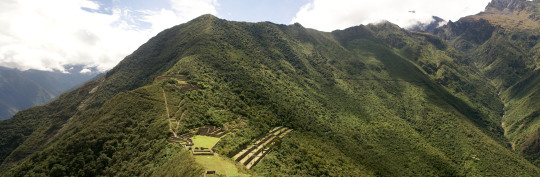
You can visit the architectural complex Choquequirao is situated in Vilcabamba at 3100 meters, considered the last Inka refuge and place of resistance from the invaders, when doing ....
Our Inca Jungle Trail classic To Machu Picchu combines adventure sports such as mountain biking, rafting, zip line, hot spring and trekking for 4 days until you reach Machu Picchu....
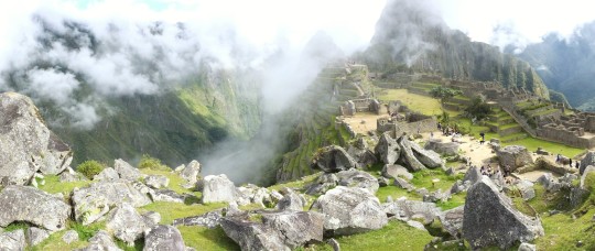
In the upper area close to the Skies, the Incas built one of their best-preserved cities, now recognized as one of the 7 wonders of the modern world. Many travelers and adventurers come....
According to the research, the coloration of the rainbow mountain is due to the composition of minerals that it has: the pink color is for the red clay, fangolitas and arilitas. The whitish, for the quartzose ...
The lost city of the Incas of Choquequirao was probably built in the fifteenth century, along with the city of Machu Picchu, during the administration of the Inca Pachacútec. However, this statement is contradicted by other historians who claim that its construction was later than Pachacútec, during the governments of Túpac Yupanqui or Huayna Cápac. Choquequirao Trek Information
In the Inca era, Choquequirao was a very important cultural and religious center that served as a commercial enclave and waypoint to Vilcabamba and Machu Picchu.
During the Inca resistance to the Spanish invasion, Choquequirao was one of the last bastions of resistance and Inca refuge. But, at the fall of the great Inca culture, the Inca people of Choquequirao passed to the forgotten one, and the immeasurable jungle was responsible for hiding it for many centuries.
Just in the early 1800s, the first explorers began to explore the lost city of Choquequirao.
But, it was not until the end of the 1990s that intensive studies began and the restoration plan began.
Currently, of the 1810 hectares comprising the Inca Llaque of Choquequirao, only 30% have been unearthed and put into operation as a tourist area. While 70% of the ruins still lie under the frond of the jungle eyebrow.
Structure
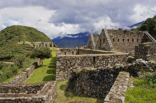
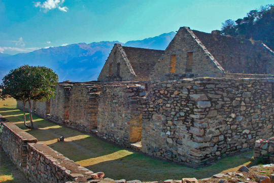
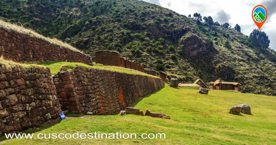
Unlike Machu Picchu, the Archaeological Ensemble of Choquequirao is a dispersed and varied settlement.
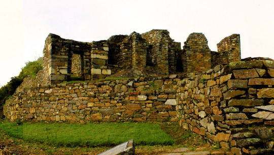
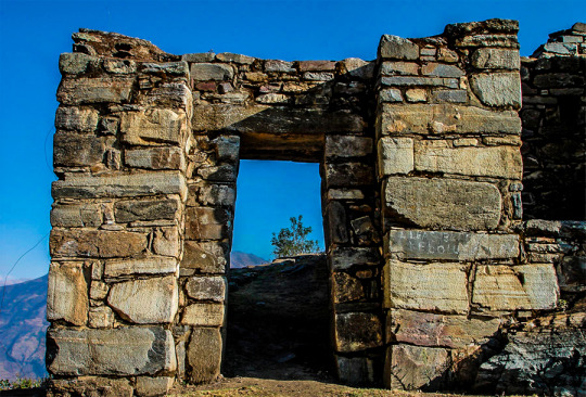
Its architectural structure was built with edged stones and mud mortar, and is composed of:
A ceremonial platform (Ushno).
An upper square (Hanan) and a lower square (Hurin).
Temples
Niches
Housing of the priests.
Deposits and barns (Qolqas).
Ditch network.
And a platform system.
Choquequirao sectors
Choquequirao is organized in 12 separate sectors (zones), whose paths converge to a large main square.
Sector I. Located in the highest part, in the Hanan area. It includes an upper main square, buildings and an aqueduct that descends through successive stone fountains (phacchas).
Sector II Located in the Hanan area, below sector I. It includes the Warehouses and warehouses (qolqas) and the “Giant Stairs” stairs of Bingham.
Sector III It is the central nucleus of the citadel. It is located in the upper (hanan) and lower (hurin) sectors. It is made up of the main square or Hauqaypata, some annexed buildings of one and two levels (houses of the rulers and Kallankas).
Sector IV Located in the Hurin or South zone, it is a main building composed of five covers that were probably used for ceremonial uses. In this place is the Temple of the triumphal wall and the sacred pens.
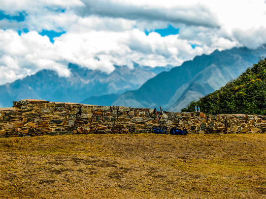
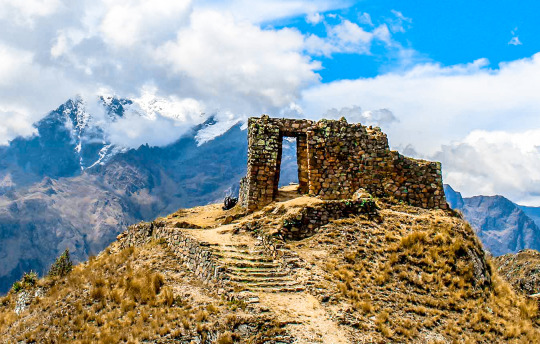
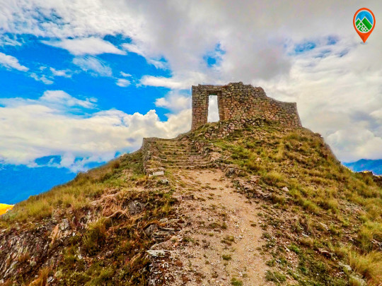
Sector V (Ushnu). Located on top of a hill. It presents a ceremonial oval platform that is surrounded by a small wall. From this place you can see much of the archaeological park of Choquequirao, the mountain range of the Vilcanota Range and the great Apurimac canyon.
Sector VI (Wasi Cancha). It is located south of the ushnu, in the lower part. Also known as temple and housing of priests.
Sector VII. Formed by cultivation platforms on the east side (monumental platforms or sacred platforms), which stand out for hosting wide and wide platforms.
Sector VIII. Made up of 80 platforms, divided into plots and water channels that descend from the main square. Here are the famous "platforms of the Flames of the Sun"
Sector IX. Constituted by popular or family homes. It is better known as Pikiwasi.
Sector X (Paraqtepata). Formed by 18 cultivation platforms and irrigation canals parallel to the stairs.
Sector XI. Located in the area called Phaqchayoq, on the right bank of the Ch’unchumayo stream. It is composed of 80 wide platforms.
Sector XII In this sector are the cultivation platforms. It is made up of 57 platforms with permanent irrigation.
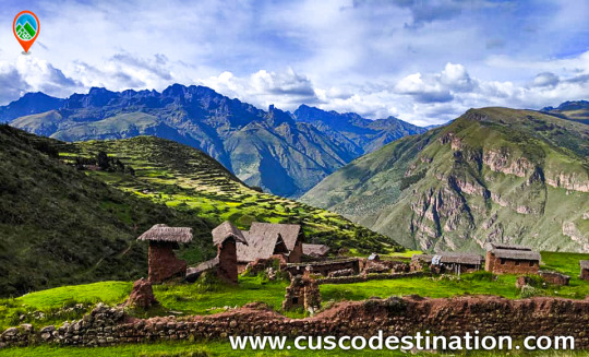
Spectacular and distant, lonely and forgotten, Choquequirao (3,085 masl) is ruled on the top of an almost impregnable mountain in the province of La Convencion, department of Cusco, reason that made it for more than 40 years the last bastion of resistance of The children of the Sun, who sought refuge in their stone walls, after the defeat of Manco Inca, the rebel Inca, will visit palaces, two-level temples, fountain systems, canals, aqueducts, and their admirable "upholstered" profuse platform Vegetation, a place worth the effort. The fatigue yields to the magnificence of Choquequirao.
More Information of Choquequirao Trek
The geographical location is northeast of Cusco between the rivers of Apurimac, Urubamba and the majestic Salkantay with a maximum height of 6,271msnm and a minimum of 2,575 meters above sea level. The Vilcabamba range offers the unique opportunity of a fascinating hike between an environment of glaciers, green mountains, bears, condors, tarantulas, etc. This cloud forest region served as a refuge and natural fortress for the 16th Inca resistance movement of the 16th century, which sought to regain control of the Tahuantinsuyo from Spanish invaders. The customs and clothes typical of local people reflect a mixture of cultures. Its tongue and textiles with Inca and Pre-Inca ornaments, give clear evidence of the influence of the Quechuas. Vilcabamba is also the region where there is a concentration of Pre-Columbian archaeological treasures, including Choquequirao and the famous citadel of Machu Picchu. There is a network of operation of the Inca roads that connects the pampas of Vitcos, Rosas pata and Espiritu Pampa.
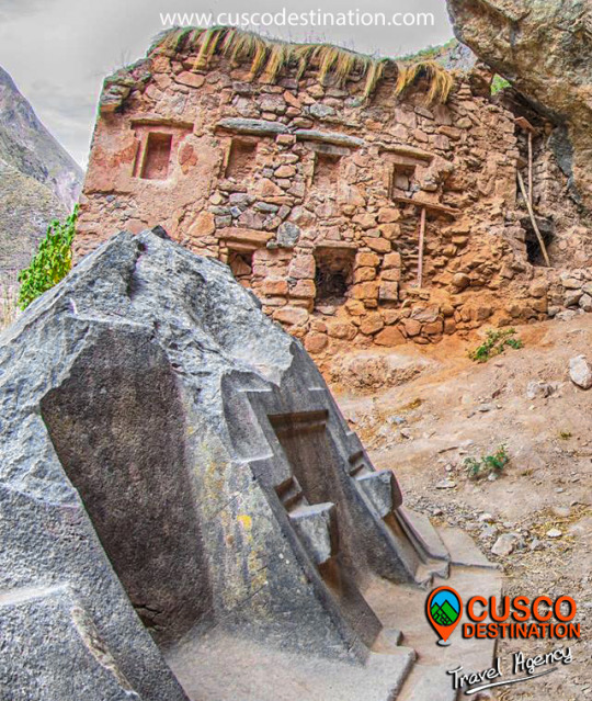
This place was dedicated to the carving and extraction of the stones that were used for the construction of Ollantaytambo and many surrounding precincts. This place is nine kilometers from the Inca town of Ollantaytambo and has three groups of quarries:
Molle Pucro, Sirkusirkuyoc (it was the largest of the three), shows evidence of having been in full operation when the Spanish entered this area. And finally Kantirayoq or Cacchicata, where another type of extraction of minerals and precious stones was practiced. The visitor will be able to observe the great work done when moving the gigantic stones to build the Ollantaytambo enclosures. We can find the so-called "Tired Stones" that stayed during the trip to Ollantaytambo and in some parts of the town.
The Walk to the Cachicata Quarries is located in the Ollantaytambo district, the living Inca city, this wonderful walk will take you to know one of the little known places where the stones were extracted for the construction of the cultivation terraces, temples and The entire archaeological complex of Ollantaytambo. We venture into a route full of beautiful and spectacular views of the sacred valley and the mystical city of Ollantaytambo.
We will take you to know the beauties that the sacred valley hides in all its splendor. We will visit the slopes of Cachiccata, the Paqariqtampu pyramid and the imposing snowfall. It will be an unforgettable experience with the best service provided by our professionals, you will be delighted with such beauty that nature offers us. Those who decide to undertake this cultural journey will return full of the ancestral spirit of the Incas and with a little piece of the Andes in their hearts.
The Walk towards the enigmatic Cachiccata Quarries will take you to know one of the little known places where the stones were extracted for the construction of the cultivation terraces, temples and the entire archaeological complex of Ollantaytambo.
The adventure will take you to one of the most spectacular routes, full of beautiful and spectacular views of the sacred valley and the mystical city of Ollantaytambo, this is one of the beauties that hides the tour to the Sacred Valley in all its splendor. This place was dedicated to the carving and extraction of the stones that were used for the construction of Ollantaytambo and many surrounding precincts.
Location:
It is located 9 km from the Ollantaytambo district, "The Living Inca City" in the province of Urubamba, Cusco region.
How to get?
On your own: The first thing is to go from the city of Cusco in a car or bus to Ollantaytambo (approximately 2 hours), once in the square of Ollantaytambo we will begin the walk: from the Plaza de Armas de Ollantaytambo take the Main Street towards Cusco, until arriving to the track, there instead of turning left where the stone street ends, continue straight on the path until you reach the Inca bridge. Cross it and walk to the right. After a 15-20 minute walk uphill, take a slope to the left at the fork, marked by a rock painted with "Las Canteras". In 20 minutes, agricultural platforms and foundations of old buildings will come into view. Follow the right trail and ignore other paths that cross. The trail will merge with a larger path. Continue through the mountain slope on this main road to the Lowe quarry, which is indicated by small stone foundations above boulders. (Minutes before reaching the quarry, the path passes through an irrigation canal, the last chance to cool off).
The first quarry is 2 hours after leaving the Plaza de Armas. Just after passing this quarry, continue on a smaller path to the left. Follow a series of zigzags to the hillside, for 45 minutes or an hour. Shortly after, the second much larger quarry will be visible on the left. The small fields on the right are a great place to camp. As a reference, a rock in the middle of the quarry painted with "National Institute of Culture".
Hiring a tour with a tour operator:
Definitely the safest and recommended option would be this, because they deal with the transfer to this archeological area better and resolve any inconvenience that may exist, are responsible for transportation, guidance, refreshment, etc.
What attractions do you have?
It has three groups of quarries:
Molle Pucro, the most accessible and popular quarry.
Sirkusirkuyoc (it was the largest of the three), shows evidence of having been in full operation when the Spaniards entered this area.
Kantirayoq or Cacchicata, where another type of extraction of minerals and precious stones was practiced.
We will also visit the slopes of Cachiccata, the pyramid of Paqariqtampu and the imposing surrounding snow-capped mountains.
We can find the so-called "Tired Stones" that stayed during the trip to Ollantaytambo and in some parts of the town.
In the same way we can observe the great work they did at the time of moving the gigantic stones to build the Ollantaytambo enclosures.
This place is also known by the Intipunku (cover of the Sun), considered as a Sacred place of Spiritual retreat since ancient times, where you can feel the energy of the Apus (mountain spirits) and recharge positive energies on the heights of the Sacred Valley.
Recommendations:
Be sure to eat and be well fed; You can bring snacks such as energy bars, nuts, chocolatillos.
Drink water: Stay hydrated during the walk is very important.
Take Coca Mate or chew Coca Leaves will help reduce and prevent altitude sickness.
Sunscreen: Be sure to apply a minimum sunscreen every 02 hours and wear sunglasses accompanied by a hat or hat.
Rain protection: There is always a chance of rain so be sure to wear rain clothes.
Wear warm and waterproof jackets and light clothes for the sun.
CHOQUEQUIRAO es un lugar tan maravilloso como Machu Picchu; menos conocido, más inexplorado. Virgen y libre de la abundante visita turística. Un Machu Picchu para llegar como mochilero, con largas caminatas independientes y acampadas en la ruta. Choquequirao es también conocida como la hermana sagrada de Machu Picchu. Se trata pues de un gran complejo arqueológico con edificios y terrazas, testimonio de los Incas conquistando las alturas de las montañas.
En esta guía aprenderás cómo llegar por tu cuenta a este santuario. Aprovecha los recursos de Cusco destination para descubrir una de las ruinas más impresionantes de Latinoamérica.
Antes debes saber un par de cosas:
¿Por qué si es tan increíble va tan poca gente o se sabe poco de él?
A diferencia de Machu Picchu a donde se puede llegar con trenes y ascender en buses, Choquequirao es un destino al que se llega a través de un intenso sacrificio y esfuerzo. Son caminatas duras que implican bajadas y desniveles con poco oxígeno. La manera de llegar es caminando mucho y acampando. Posiblemente tu abastecimiento de agua no sea suficiente, pases frío en las alturas o bien te quemes caminando bajo el intenso sol andino. El viaje completo puede hacerse entre 4 y 5 días salvo que quieras visitar algunos pueblos aledaños o hacerlo rápidamente.
¿Cuánto se camina hasta Choquequirao?
Desde el poblado de Cachora hasta Choquequirao se caminan alrededor de 31 kilómetros sin incluir el recorrido por las ruinas. De regreso sería la misma distancia (62 km en total). Una gran parte del recorrido implica la bajada de una gran montaña mientras que la otra mitad es en una subida.
¿Aqué altura está Choquequirao?
La ciudadela se encuentra a 3,035 m.s.n.m y en el punto más bajo de la caminata estarás a 1,461 m.s.n.m. El clima es similar al de Cusco por lo que es recomendable acondicionarte a las alturas antes de la caminata.
Machu Picchu without hesitation is considered as the tourist icon of Peru, and of the more than 3 million tourists who visit us a year, more than 98% have a look at Meet Machu Picchu. However, in Peru there are places that can also be considered a tourist icon of Peru, but due to the little marketing they are given, it does not become known as Machu Picchu is now. informacion de Choquequirao Trek.
CHOQUEQUIRAO: Considered by many tourists who visited it like the other Machu Picchu and sometimes many tourists dare to say that it is better than Machu Picchu. The best thing about this archeological center is that it can only be accessed by walking as it does not exist, railways or roads that can take you to or near Choquequirao, so it is done full trekking many tourists consider this crossing as a Pilgrimage, an escape from the routine, an own challenge, escape from the bustle of the city, and being not well known sometimes the route is empty (without tourists) and on other occasions one can run into some tourists and these are few . Of course, sometimes the route can be full of tourists (nationals, school promotions and foreign tourists.). But almost the whole year the route is with few tourists. Choquequirao tour or trek: being a not very well-known or popular route, it is difficult to gather groups, so most of the time it is operated only in private service, thus raising operating costs. As an example, only the transportation service from Cusco in a minivan to Cachora, which is a starting point, costs around 300 to 400 dollars per way and another one equal to return. To this cost must be added the fees of the guide, Cook, freight forwards, fee of the person in charge of the commonly known as arriero, also the costs of food, tents, gas, agency fee, taxes, etc. All these costs make an organized excursion from Cusco to Choquequirao very expensive, and this causes many tourists to be discouraged from doing so and looking for other options or trying to do it on their own.
This is a spectacular hike through the Andes of Peru. You can visit the architectural complex of Choquequirao, which is situated in Vilcabamba at 3100 meters, and is considered the last Inka refuge and place of resistance from the invaders. When doing this trek you will enjoy hiking in beautiful scenery, you'll see the impressive Apurimac Canyon, you’ll see flora and wildlife in the path. This route offers a strenuous but formidable journey due to the various existing ecosystems. Information of Choquequirao Trek
Useful Information
- Starting Altitude - 2900m / 9515ft. - Highest Altitude - 3050m / 10,005ft - Walking Distance - 64 km / 40 miles - Longest Day - Day 1, approximately 25 km/15.5 miles - Overall Difficulty - Difficult
IMPORTANT INFORMATION:
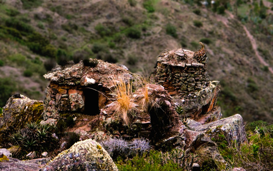
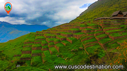
Because of its altitude, Choquequirao has a temperate climate. However, it should be noted that the road to Choquequirao is warm because of the Apurimac canyon. Choquequirao was presumably used as a control site to ensure access to areas of Vilcabamba, connecting the jungle with other major centers like Pisac and Machu Picchu. The archaeological remains of Choquequirao are comprised of buildings and terraces on different levels, in which their terraces stand out due to 22 carvings on stone with figures known as "Llamas del Sol" arranged in 15 platforms towards the snowy Qori Hauyrachina. Choquequirao features a large system of platforms/terraces.
Brief Itinerary - Day 1: Cusco – Cachora – Chiquiska. - Day 2: Chiquiska – Choquequirao. - Day 3: Choquequirao - Day 4: Choquequirao – Coca Masana. - Day 5: Coca Masana - Cachora – Cusco.
t is located at 13 ° 32 'south latitude and 72 ° 44' west longitude. It is located at 3035 m.a.s.l. in the foothills of the snowy Salcantay, north of the Apurimac river valley, in the province of La Convencion in the department of Cusco. It is approximately at a distance of 47 km. with reference to the town of Cachora (department of Apurimac).
We can mention that the Choquequirao environment is one of the richest in biodiversity. All these species have been conditioned despite temperature variations such as sun throughout the day and inclement frosts during the night. The fauna of the place is mainly composed of condors, tarucas, vizcachas, foxes, skunks, pumas, hummingbirds, spectacled bears and the popular rooster of the rocks, national bird of Peru. Giant ferns, ichu and a great variety of orchids stand out in its flora, where the wakanki variety stands out. Weather
Because of its geographical position, Choquequirao trek has a warm climate alternated with cold temperatures at night. The average annual temperature is 17ºC. History
During the Inca civilization it was a cultural as well as religious center for the region. Well, it is presumed that this citadel was used as a checkpoint to ensure access to the areas of Vilcabamba, which connected the jungle with other important centers such as Písac and Machu Picchu. It is also estimated that the citadel played an important role serving as a link between the Amazon rainforest and the capital of the Inca empire (Cusco).
At the time of transition that lasted approximately 40 years, Choquequirao is considered one of the last strongholds of resistance and refuge of the Incas, who by orders of Manco Inca, left the city of Cusco to protect themselves in the cities of the Vilcabamba region, when around 1535 Cusco was controlled by the Spanish. It was in this place (and in general throughout the Vilcabamba Valley) where Manco Inca and the last Inca descendants of Vilcabamba where they resisted the attack of the Spaniards, until the capture and execution of Túpac Amaru I that happened in the year 1572.
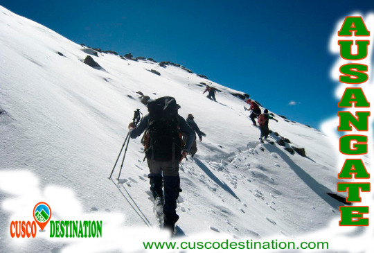
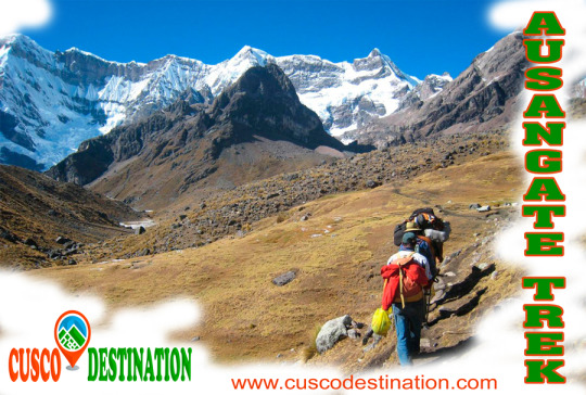
The Ausangate trek Circuit is definitely an adventure route recommended for those who like hiking, feel nature, the spirit of the mountains, and the energy of Mother Earth. The Ausangate circuit offers some of the most beautiful landscapes of Cusco, with varied wildlife, glaciers and Andean lagoons. Ausangate Trek is also one of the most difficult hikes in the region. The most important thing about this trip is that you’ll get to see the real PERU, the Andes and its people in their traditional dress, their customs that persist till today.
Useful Information
**- Starting Altitude **- 3350 meters / 10990 feet .
**- Highest Altitude **- 5200m / 17,056ft.
**- Meals **- 6 breakfast, 6 lunch, 6 dinner, 6 tea times, 6 wake up tea
**- Overall Difficulty **- Moderate - Changing
**- STARTING POINT: **- Cusco at your hotel IMPORTANT INFORMATION:
Ausangate is the fifth highest mountain in Peru; its maximum altitude is 6,372 meters.
The hike up the mountain of Ausangate is considered adventure tourism. The road presents rock formations at a height of over 5000 meters covered by ice tongues.
The waters of the snowmelt flowing westward give origin to the Vilcanota River, which subsequently flows into the Amazon River and ends up in the Atlantic Ocean.
Its eastern slopes feed several small rivers that culminate in the Inambari River and to the south it drains its waters into Titicaca Lake with the river Azángaro.
The temperature in the day is between 11 and 13 degrees Celsius and at night it drops to 4-10 degrees Celsius in June and July.
Brief Itinerary - DIA 1 : CUSCO - TINQUI – UPIS- DAY 2: UPIS - JATUN PUCACOCHA- DAY 3: JATUN PUCACOCHA - PAMPA CANCHA- DAY 4: PAMPACANCHA - LAGUNA TICLLACOCHA- DAY 5: LAGOON TICLLACOCHA - PACCHANTA- DAY 6: PACCHANTA - CUSCO
“2 brothers (Salkantay and Ausangate), which lived in Cusco decided during the great draught in Cusco to travel to other lands and find the remedy for their people. Salkantay went north to the jungles where he met the forbidden love of beautiful Veronica and lots of problems. The other brother – Ausangante went south. He found a fertile valley and could send potatoes, maize, lama meat and alpaca to Cusco and therefore saved the inhabitants of the city”. AUSANGATE TREK
This is the legend told by Quechua Indians about the Brothers-Mountains.
Ausangate is the highest peak of the second largest Peruvian glaciated system Cordiliera Vilcanota (120km long). Cordiliera Vilcanota is located approximately 100km south-east of Cusco. The magnificent Vilcanota River begins in these high glaciers and goes on to feed the Amazon River and Atlantic Ocean. Ausangante with its 6384 m / 20940 ft elevation above sea level is the fifth highest peak in Peru (and one of the highest peaks of South America) after Huascaran, Yerupaja, Coropuna and Huandoy.
In the mid 20th century several expeditions tried to climb Ausangate. The first mountaineer was Italian Piero Ghiglione who tried to conquer Ausangate in 1950. After the first unsuccessful try he returned in 1952 with multinational expedition. But this time the expedition also failed to reach the main peak of Ausangate. Finally, in 1953 the Autsrian-German expedition became the first to reach the top of Ausangate. The first Peruvian expedition to climb Ausangate was 30 years later!
Qoyllur Rit’I Festival
Ausangate – one of the main Apu (mountain spirits) is the deity of Cuzco. During the Incan Empire the Indians worshipped and celebrated this god. After the Spanish colonisation this festival became an amalgamation of the Indian worship of mountain spirits, and the celebration of the apparition of Christ on the mountainside. Qoyllur Rit’i is celebrated at the end of May – beginning of June and continues for several days. Qoyllur Rit’i in Quechua means “Snow Star”. This festival is held at Sinakara, at the foot of Mount Ausangate. The festival attracts more than 10 thousand pilgrims every year from surrounding villages and from all other parts of the country, even from the neighbouring countries. The arrangements start with raucous celebrations near the chapel. People in national costumes dance traditional dances. However, these are not the main events of Qoyllur Rit’i.
Groups of Queros indigenous people climb Ausangate Mountain, at 6362m, in search of the Snow Star which is reputedly buried within the mountain. The foreigners are not allowed to participate in this climb, according to the Indians, this may offend Apu Ausangate. For several days the pilgrims walk to the top of the mountain: through the dangerous paths and freezing passages, gasping for breath in the thin air, and overcoming numerous difficulties. The accidents are quite frequent – not everybody returns back (in this case, the Indians say that Apu Ausangate received its sacrifice). All of this is done for one purpose; to bring a block of ice to the Chapel. They people believe that the ice brings luck, has medical effects, and that the lands irrigated with this holy water will be very fertile.
Climbing Ausangate Ausangate trek is not for beginners! If you think that you are experienced enough for this ascent, spend enough time in Cusco before climbing the mountain, to allow yourself time to become acclimatised to the region.
How to get there
There are two routes from Cusco to Ausangate
Route 1: Take the intercity bus to Chillca village. From there you can walk to Campo Base - the starting point of the trek (it will take you 4 to 5 hours).
Route 2: Take a bus to Tinqui village then to Pacchanta. Then continue by foot through Acepo ravine (8 to 10 hours) to Base del Ausangate – the best starting point of the trek according to most mountaineers.
If you don’t have enough experience for independent hiking, you can visit Ausangate and marvellous surrounding areas in the company of experienced guides.
Ausangate Mountain is a natural attraction that is located in the district of Ocongate, within the province of Quispicanchi, in the department of Cusco. That snow is part of the Vilcanota mountain range and, according to an ancient legend, was the brother of Salkantay snow.
The Ausangate Snowy, has a height of 6,384 meters above sea level; and it is considered an apu, or protective deity of the surrounding peoples; as well as the most representative mountain in the region. Its size is such that it can be appreciated even if one is in the Fortress of Sacsayhuamán, not in vain is considered the fifth highest mountain in Peru.
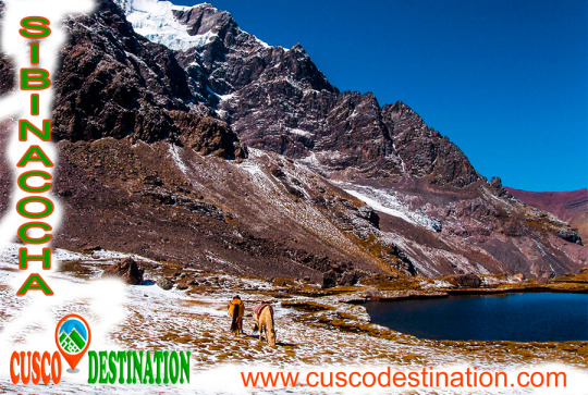
This beautiful snowy Cusco, impresses the eye, for its incredible natural formations; In that one there are not only beautiful mirrors of water such as Sivinicocha, turquoise waters, but also forests of stones, glaciers and high-plains that seem to make this natural attraction a paradise on earth, especially for those tourists who are interested for adventure sports since, the Ausangate landforms make it ideal for sports such as rock climbing, ice climbing, trekking, among other activities. Snowy Ausangate is presented before our eyes as a mountain challenge; it is known, that the first attempts to ascend it were made at the beginning of the fifties of the last century, were the first frustrated attempts to conquer the top of the powerful Apu, it was not until 1953, when a German expedition achieved the goal, climbing the mountain along its southern slope, in posterity, new routes were opened for the conquest of the Apu, however, only in 1983, thirty years after the first ascent, Peruvian feet crowned the top of the majestic snowfall.
Huchuy Qosqo, Quechua word meaning "little Cusco", is an archaeological complex that is not within the regular package to the Sacred Valley of the Incas, this makes it ideal because it is not crowded like Ollantaytambo and Pisac.
The archeological center of Huchuy Qosqo, is located in the north of the Sacred Valley of the Incas in the immediate vicinity of the province of Calca, district of Cusco. This archaeological complex is one of the most important in the Urubamba valley due to its architectural level, after Ollantaytambo and Pisac. The ruins are impressive, although the conservation of the site is inferior to that of the other two because their constructions are older. The complex includes platforms, courtyards, esplanades, squares, pedestrian path and buildings of different magnitude and quality.
One of the main attractions of Huchuy Qosqo, is a three-story building or levels; The first two are made with finely carved stone and the third level is made of adobe and although it has been lacking a roof for a long time, it is so resistant that it has been standing for more than 500 years.
There are many ways to get there, you can take a taxi from the town of Calca (1 hour from Cusco) to the door of the same complex that is 3550 meters above sea level. The other way is a 5-hour walk from the Laguna de Piray (45 min. From Cusco), where you can enjoy a majestic landscape. This road begins in the town of Cuper, (10min. From the lagoon of Piuray), here the ascent begins until you reach the Abra and from there you follow the Inca trail, which apparently is part of the famous Qapacñay; From here you pass through a beautiful rocky canyon, where you will see the purple, green and red colors of the stones, until you reach the top of the mountain and appreciate the splendor of the Sacred Valley. The road is signposted, but it is always better to ask the muleteers and farmers in the area the exact location of the accesses.
In Huchuy Qosqo you can see an esplanade next to an abyss where you can see Inca constructions, terraces, rooms with up to two floors, canals and everything looks spectacular because they are built on platforms. Huchuy Qosqo Trek to Machu Picchu
The archeological zone of Huchuy Qosqo (Cusco Small), which was known during the Inca period as Qaqyaqawana (which in Spanish means “place from where you see the thunder”), is located in the district of Lamay, within the province of Calca, in the department and region of Cusco, specifically in a plain found on the top of a mountain. At a height of 3 550 meters above sea level. And it is currently considered, thanks to the National Institute of Culture, as Cultural Heritage of the Nation. HUCHUY QOSQO ROUTE TO MACHU PICCHU INFORMATION:
On a historical level, this site is known as the preferred place of the Inca Wiracocha, which he chose as a place of rest and retreat and, where, according to the myth, he died at an advanced age (80 years old). It is also said that this area was already populated by different ethnicities, before the Inca arrival, so they had to be previously defeated. Another striking story about the area is that the Inca Wiracocha had not come only there, but in the company of his son: Inca Urco, the worst ruler of the Empire, who abandoned their Tahuantinsuyo fate after the Chanca attack that ended up being stopped by his other son Cusi Inca Yupanqui. Finally, another reason that makes this site important is the discovery of a mummified body, found during the Conquest, and that would have been attributed to the old Inca monarch, although later burned by Francisco Pizarro's brother.
As for its location, it can be added in addition to the access feature, which provides the visitor (and those who lived in the archaeological center) a great view of the snowy Pitusiray along with the town of Calca.
Regarding the architectural remains that have still been preserved on the site, we can say of them that there are at least 2 buildings, in addition to the presence of platforms and cliffs. Among the buildings, built on the basis of some of stone and others of adobe, we can observe, one of three floors, without name; This first construction is characterized by the presence of the mixture of the construction materials, since the two lower levels are made of carved stone, while the last one preserves adobe-based structure. The second building, also without a name, is a rectangular-based construction, made with adobones, which is believed to have had the purpose of being a space for the labor learning of the women of the Empire. There are also vestiges of remains of smaller enclosures that are almost destroyed due to natural events, including rains and vegetation in the area.
To get to the place the exact location of Huchuy Qosqo is necessary to make a walk, due to the narrow road, it lasts 3 hours from Lamay; on the other hand you can also go from Chinchero, using half a day of pilgrimage; and if you want to make a trip to the site, of longer duration, in which camping is required, you can take the route from the City of Cusco, since this route takes the entire day. The entrance to the site is totally free, although it is recommended that the tourist be done in the company of guides or in groups; Another recommendation is that this tour be carried out in the dry weather period, between the months of April and October, to avoid the slippery area due to the rains.
This complex is the most important archaeological center in the Urubamba Valley, after Ollantaytambo and Pisac. The ruins are impressive, although the conservation of the site is inferior to that of Ollantaytambo or Pisac, because they are older.
But unlike the places mentioned above Huchuy Qosqo has a peculiar architecture: the buildings have been built on polished stone bases of fine finish, with clay plaster (they are the best preserved parts) and the highest floors are made of adobe.
Treks of Huchuy Qosqo Trek
There is a kallanka (rectangular enclosure that could measure up to 70 meters long and that were important state centers where Inca officials were staying) of at least 40 to 50 meters long. Also a remarkable building with two stone floors and an adobe upper one. There are also large terraces, a very wide square and a large Inca gate through which a very well preserved road leads from Tambomachay.
The Hispanic chronicles indicate that Huchuy Qosqo (probably a site known in Inca times as Caquia Jaquijahuana) was the work and favorite place of the Inca Wiracocha. To this, Maria Rostworoski adds, in her work "History of Tahuantinsuyo", that this sovereign strengthened the conquest over the villages of the Urubamba Valley and that he chose as his successor his son Inca Urco who, dizzy from power and vice, He proved to be totally unable to govern. The Inca royalty was very obfuscated with this election and tried to conspire to impose another son of Wiracocha, Prince Cusi Yupanqui. Social unrest and tension increased every day and to make everything worse, the darkest night fell over Cuzco: the Chancas reached the gates of the capital and were willing to destroy it. It is the year of 1438. Wiracocha leaves the city to his fate and, accompanied by his son Inca Urco, takes refuge in its palaces in the Urubamba Valley, among which was Huchuy Qosqo.
After the Hispanic conquest, Gonzalo Pizarro found here the mummy that supposedly belonged to the Inca Wiracocha and ordered it burned. The descendants of the Inca kept the ashes in a jar that many years later the chronicler Polo de Ondegardo would discover.
Characteristics of the visit It is possible to visit Huchuy Qosqo in three ways, the first one walking from Cusco and Tambomachay along the Inca trail. The other way is up from the Sacred Valley after crossing the Wilcamayo River (now Vilcanota) and the Chinchero route.
The quarry of Cachicata was the place of extraction of the stones that were used for the construction of Ollantaytambo and many surrounding areas. This place is 9 kilometers from the Inca town of Ollantaytambo and has three groups of quarries: Molle Pucro, Sirkusirkuyoc (it was the largest), shows evidence of having been in full operation when the Spaniards entered this area. And finally Kantirayoq or Cacchicata, where another type of extraction of minerals and precious stones was practiced.
- Starting Altitude - 3350 meters / 10990 feet . - Highest Altitude - 4500m / 14,764ft - Walking Distance - 25 km / 15.5 miles - Meals - 4 breakfast, 3 lunch, 3 dinner, 3 tea times, 3 wake up tea - Overall Difficulty - Moderate - STARTING POINT: - Cusco at your hotel
IMPORTANT INFORMATION:
The Community of Cachiccata consists of 80 families and a total of approximately 300 people. The quarries of Cachiccata is one of the most important attractions, these quarries were widely exploited in the Inca period. From this mine they selected and transported the stones from the archaeological remains of Ollantaytambo. By means of own bearing and thrust techniques, the stones were transferred to this old center. On the way we can see giant semilabrated stones that were being transported. Near the quarries we can also visit some pre-Hispanic chullpas (ancient funerary tower). Machu Picchu is one of the 7 Wonders of the Modern World, Heritage of Humanity, Historical Sanctuary of Peru and probably the most important archaeological site in Latin America. Machu Picchu is majestic architecture comprises 140 structures throughout the citadel. Machu Picchu is was built by the Inca Pachacutec around the year 1460 After being forgotten, it was only in 1911 that the American Hiram Bingham reached Machu Picchu on an expedition and spread the site worldwide.
Brief Itinerary - DAY 1: CUSCO – SOQMA – RAYAN - DAY 2: RAYAN – INTI PUNKU – CHOQUETACARPO - DAY 3: CHOQUETACARPO – OLLANTAYTAMBO – AGUAS CALIENTES - DAY 4: MACHU PICCHU - CUSCO
Ollantaytambo is another of the many places where we can admire the archaeological wealth that the Incas left us. It is a population that is part of the province of Urubamba and the department of Cusco.
It is located at the convergence of two valleys crossed by the Vilcanota, which the Incas called Willcamayu (Sacred River) and the Patacancha. At an altitude of 2,790 m.a.s.l.
One of the routes I do frequently, is towards the Inca quarries of Cachiccata. The last ascents I have initiated from the Inca bridge that is at the entrance of Ollantaytambo coming from Urubamba. This bridge consists of two eyes over the Vilcanota River (or Urubamba River). Its bases, of Inca origin, are made up of large blocks of stone and, to protect the central pillar, they placed two huge rocks as a water-breaker in the course of the river. In its origin, this bridge must have been a suspension, and like so many others that the Incas did, it was made with the braiding of a plant called “ichu”, which is still used today on the roof of many Andean houses.
INFORMATION OF INCA QUARRY TREK
Once across the bridge, the ascent begins on the left bank. A sign shows us the route to follow, while we have a good view of the platforms that surround Ollantaytambo.
In front of the train station we will encounter a rocky ledge on which there are the ruins of a control or defensive fort known as Choquequillca. On the other side of the Vilcanota River (right bank) we found no fortification, perhaps because it was destroyed with the layout of the railway. Our goal is to visit the Cachiccata quarries and then continue the ascent to the top of the Arequipa Hill, where there is an Inca archaeological structure, known as INTI-PUNKU (Puerta del Sol). The distance between the Inca bridge of Ollantaytambo and the INTI-PUNKU is about 8 km with 300 m. following a pedestrian trail. This journey can be done in one day without trying to break records. It is convenient to get up early to avoid the intense midday sun.
The initial road runs parallel to the Vilcanota River, with terraces on the left side. In front, on the other side of the river, we can contemplate another architectural group of the Inca culture; It is called Raqaypata.
A second part of the road, much wider, takes us to the bottom of the Cachiccata quarry (in Quechua it means “salt slope”). It is a continuous ascent to save the 400 m. of unevenness between the starting point (2800 m altitude on the Ollantaytambo bridge) and this lower quarry located at 3210 m.a.s.l.
Along this second journey, which is one of the ramps through which the Incas slid the pink stone blocks, we found some of these large stones that did not reach their destination and are known as “ Tired Stones. "
Here are two copies: the first one is located in front of the church of San Santiago Apostol (Ollantaytambo) and the second one is found on the way up to the quarry.
It is not uncommon to find tour groups accompanied by a guide, and pack animals transporting the materials of a long journey. It is also common to find people picking aromatic or medicinal plants (muña, tara, ...) It is obligatory for me, when visiting these places, to visit Don Guillermo Qawa; an old man who lives alone at 3022 m altitude and with whom I share a “little time” of company and some food, every time I make this route.
Why not mention the children Francisco, Roqui, Yéssica, Lourdes and Lisbeth to whom on this last walk we offered the promised toys?
The Cachiccata quarries are located under the impressive Black Good Apu from which the Incas extracted the huge blocks of pink rhyolite. These stones were partially worked in the quarries and then down to the Vilcanota River in front of the Rumira sector.
Through an artificial channel parallel to the riverbed, they diverted the water alternately (in times of drought) and thus moved the blocks on either channel with an island in the middle. The blocks were dragged back to the fortress of Ollantaytambo.
The last section consisted of a steep ramp, which can be seen perfectly from the left bank of the river, as shown by the arrow in the photograph. We know, from the tools that the Incas abandoned in the quarry, that they used the same stone for the extraction of the blocks: granite and basalt strikers, obtained in the Vilcanota River. These quarries had to be abandoned when Manco Inca retired from Ollantaytambo.
The last section consisted of a steep ramp, which can be seen perfectly from the left bank of the river, as shown by the arrow in the photograph. We know, from the tools that the Incas abandoned in the quarry, that they used the same stone for the extraction of the blocks: granite and basalt strikers, obtained in the Vilcanota River. These quarries had to be abandoned when Manco Inca retired from Ollantaytambo.
As for the transfer of the immense stones, we do not stop questioning the time, the way and the enormous amount of people contributing their strength and ingenuity. There is no doubt that the Inca people were construction experts; his numerous works that still endure so testify: Coricancha, Sacsayhuamán, Ollantaytambo, etc.
In the northern (lower) quarry of Cachiccata there are small constructions known as “CHULLPAS”. They are tiny towers of circular base, built with stones joined with mortar of red mud and straw. These are funerary constructions that abound in the Highlands of Peru and Bolivia, typical of the Qollas.
Those of Cachiccata, due to their small size, we deduce that they served as burial for a single person, in which they generally placed the deceased in fetal form along with some of their belongings. They have an opening or entrance in a rectangular shape and have the upper part or roof covered. Some are very damaged and others have completely disappeared; all have been looted by treasure hunters (Huaqueros).
At our feet is the small town that gives name to these quarries: CACHICCATA. A peasant community of about 80 families with approximately 320 people living on agriculture, especially corn and potatoes.
After replenishing forces, we continue the ascent to the west and south quarries. In both we find stones of greater size and better worked, as well as a limited enclosure in which the stones extracted from the quarry were stored and worked. From this place we can contemplate a spectacular landscape: · The wide valley crossed by the Vilcanota river with its diverse green tones, characteristic of the rainy months; and in the middle, the famous pyramid of Paccarectampu. Regarding this truncated pyramid of Ollantaytambo, certain writings relate it to the founding beginnings of the Inca Empire. What we can confirm is that during the winter solstice (June 21), with the sunrise, it is possible to observe different light effects through solar projections on this pyramid of Ollantaytambo.
· Al Al frete, the imposing peaks of the Vilcanota Range, among which the Apu (divinity) or Veronica Snow also known as Wakaywilque with its 5,682 m.a.s.l. struggling to peek her white hair between the clouds that surround her.
I was surprised to find in these quarries a stone wheel (like an old mill) apparently unfinished, because the central hole was completely unperforated.
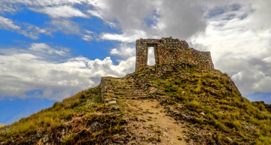
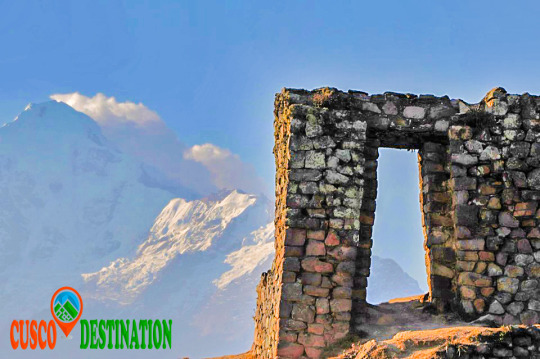
Continuing our ascent, the next stop was at the archaeological remains of Choquetacarpo located at 3,495 m.s.n.m, of which we do not know the purpose they had, although it seems to have been the residence of those who managed the quarry.
The trip continues in its last stage of ascent until reaching 3,943 m.a.s.l. With your eyes fixed on the INTI-PUNKU (Puerta del Sol) and the desire to complete the feat of reaching that altitude, forces arise under the intense sun and dizziness from the height. MACHU PICCHU TOUR
They are the last meters, some steps and we access the Puerta del Sol. An impressive spectacle appears before our eyes. Mute and contemplate is the most appropriate. Praise be my Lord!