You can visit the architectural complex Choquequirao is situated in Vilcabamba at 3100 meters, considered the last Inka refuge and place of resistance from the invaders, when doing ....
Our Inca Jungle Trail classic To Machu Picchu combines adventure sports such as mountain biking, rafting, zip line, hot spring and trekking for 4 days until you reach Machu Picchu....
In the upper area close to the Skies, the Incas built one of their best-preserved cities, now recognized as one of the 7 wonders of the modern world. Many travelers and adventurers come....
According to the research, the coloration of the rainbow mountain is due to the composition of minerals that it has: the pink color is for the red clay, fangolitas and arilitas. The whitish, for the quartzose ...
Showing posts with label travel to machu picchu. Show all posts
Showing posts with label travel to machu picchu. Show all posts
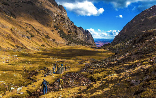
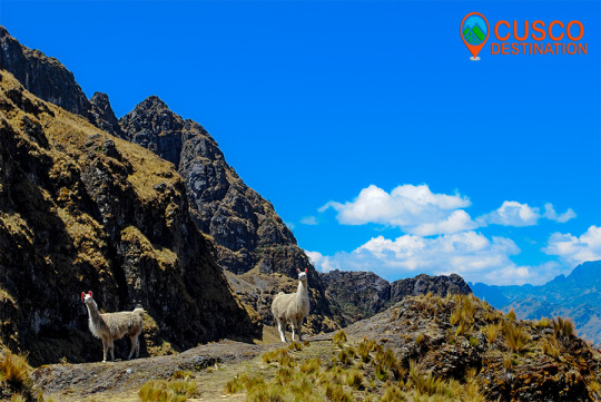
The Lares Valley is located between the eastern slopes of the Andes and the northern part of the Urubamba Mountain Range, it is a place with beautiful glacial lagoons and warm subtropical ravines, it also has a great variety of vegetation and wildlife. information of Lares Trek
It is surrounded by a mountain chain of the mountain range, where the snows of Verónica, Sawasiray, Pitusiray and Chicón are located. Small communities of Quechua-speaking farmers live here, who maintain their customs of grazing llamas and alpacas, growing tubers and producing tissues.
For all the above, this valley grants a great variety of tourist attractions. It is common for tourists to come to Lares to interact with local communities and learn more about their traditions, and it also gives the possibility of doing one of the best trekking routes in Cusco.
Location
It is located in the province of Calca, in the department of Cusco.
Climate and temperature
Between the months of May and October the area presents a sunny climate, with a temperature from 15 ° C to 21 ° C. From the months of November to April it is rainy season.
Altitude
It has a height of 3,170 masl.
How to get to Lares Valley
To get to Lares you can access by doing 2 routes. The first Cusco - Pisaq - Calca - Lares and the second Cusco - Chinchero - Urubamba - Calca - Lares. The road is in very good condition but it still takes time to reach the destination, it is advisable to hire the services of an agency to reach the Lares Valley.
Medical tourism is a type of tourism that is gradually acquiring a greater number of followers, and that has in the Peruvian territory an impressive range of resources to choose from, since if there is something that abounds in all regions of the country These are the sources that, in addition to relaxing and relieving the visitor from stress, are capable of relieving any suffering they may have.
The Thermal Baths of Lares, are one of these thermomedical resources that the traveler will be able to enjoy when he goes to a region like Cusco. These thermal baths, as the name suggests, are located in the district of Lares, which is located in the province of Calca.
Lares Thermal Baths are made up of a group of four swimming pools. These are fed by waters that are tempered to different degrees. The temperature of the thermal pools of Lares fluctuate between 36 ° C and 44 ° C and the pools have dimensions between 17 m2 and 120 m2, with depths that do not exceed one and a half meters, making it suitable for a greater number of visitors.
These thermal baths are visited by the properties that present their waters, which in addition to offering comfort and stress relief are able to relieve certain conditions. This is achieved thanks to the fact that the waters of these Thermal Baths of Lares are fed by minerals such as sodium, potassium, magnesium, calcium, iron, zinc, among many others, which together allow us to fight diseases such as arthritis , osteoporosis, in addition to contributing to the rehabilitation of broken bones, combating muscle, stomach problems, among many others.
To get to the Lares Thermal Baths, the visitor has to travel from the city of Cusco to Calca, this tour can take approximately an hour and a half, and can be done on a public bus, this usually charges approximately S / 4.00 per passenger. Already in Calca a combi is taken that in two hours leaves it in the district of Lares, the cost of this vehicle does not usually exceed S / 10.00. From Lares you should only continue on foot for approximately 1 km to the thermal baths. This last tour can be completed in just fifteen minutes, depending on the physical conditions of the visitor, if you want you can also rent a taxi.
Those who visit the Thermal Baths of Lares should keep in mind that the only tourist infrastructure that exists in the place is the hot springs, and that the closest services can only be found in the city of Calca and Lares, despite these inconveniences, the environment The Lares Thermal Baths are more than suitable for camping, so the traveler will have the opportunity to enjoy the benefits of these waters for a longer time.
In order to access the Lares Thermal Baths, the visitor has to make a payment whose cost ranges between S / 3.00 and S / 5.00. Visits to these thermal baths can be made at any time of the day. LARES TREK INFORMATION
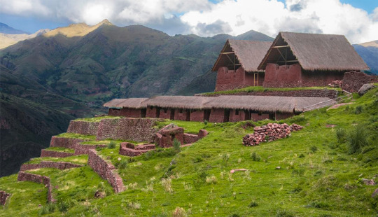
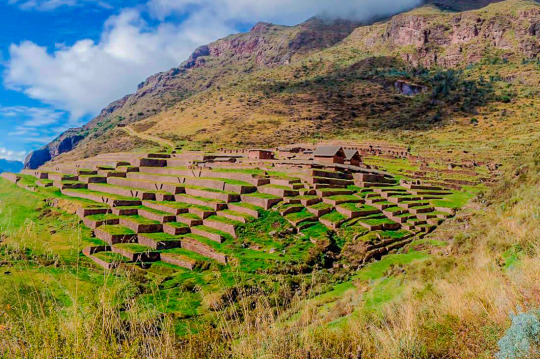
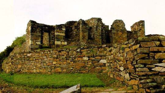
Huch’uy Qosqo (Quechua: “Little Cuzco” also called Yuchuy Cuzco) is an archeological site 50 km north of Cusco, in Peru. It is located at an altitude of 3,600 meters, above the city of Lamay, in the district of Calca, province of Calca, in the Sacred Valley of the Incas.
The site was named in the twentieth century; He had previously been known as Kakya Qawani. Pedro de Cieza de León, in his Second Chronicle of Peru, said that the palaces were built by Viracocha, the eighth Inca ruler. Among a large number of buildings, some of stone, some of adobe, is a Kallanka (large hall) 40 m long. The water supply is an Inca built irrigation canal, filled with stones of about 800 meters.
Huchuy Qosqo was probably established as a royal estate by the Inca Emperor Viracocha around 1420 CE
The Spanish took control of Kakya Qawani in the year 1500, after the Inca Manco Revolution (approx. 1540) and the site is used as a farm. Villagers built several small reservoirs for irrigation. During their time in Huchuy Quosqo, the Spaniards demolished some other Inca structures to build the largest reservoir seen today.
Below the main site of Huch’uy Qusqu is the recently restored storehouse for meat and crops such as corn, potatoes, quinoa and dried beans. In this two-story structure, you can see the historic refrigeration storage system known as ‘conjeras’.
The settlement in the archeological ruin in Huchuy Qusqo dates back to between 1000 and 1400 CE. In the early 1400s, according to the Spanish chronicler Pedro Cieza de León, it became a real property of the semi-mythical Viracocha (c. 1410-1438), the eighth Inca ruler.
The Inca Empire did not impose the income or production of its citizens as a common practice, but rather controlled the land and labor. Thus, the Inca leaders acquired great real properties to increase their power and wealth and that of their descendants who inherited the properties. The royal properties also served as elegant rural palaces and sometimes fortresses to defend themselves against their rivals for power. Thus, the name Huchuy Qosqo, "Little Cusco", for a real property or government center modeled in the Inca capital.
To build, operate and maintain their assets, Viracocha and its descendants required a large number of workers. The citizens of the Inca empire were obliged, under the mit’a system, to contribute labor to the Empire, instead of paying taxes on their wealth or production. Mit'a impressed labor was probably found among nearby ethnic groups, although specialists and artisans could be imported.
Another Inca policy, that of mitma, was probably used to collect labor for the royal heritage. The mitmaqkuna were entire families or ethnic groups that moved to new lands in the empire or settled in enclaves among the first inhabitants of an area. The purpose was to widely distribute the different ethnic groups, thus separating potential troublemakers and reducing the possibility of organized resistance to the Incas. The mitmaqkuna were discouraged from mixing with local ethnic groups. A third source of work for the farm was the Yanakunas, the permanent servants of the Incas. The Yanakuna often reached high positions in the Empire, and as the mitma were ruled directly by the Incas. Still a fourth source of work for the royal states was aqllakuna, abducted women who lived together and produced textiles, an important source of Inca wealth, and chicha, the fermented drink consumed at parties. The Allakuna used to marry men honored for their service to the Empire.
These four sources provided the work and experience for the management of a real estate that could control thousands of acres of agricultural and grazing land, mines, textile factories and other resources and employ thousands of people. The sixteenth-century Spanish sources identify more than 40 ethnic groups found in an area of the Sacred Valley, an indication of the degree of resettlement and disruption of the population undertaken by the Incas during their reign.
Among a large number of buildings, some of stone, some of adobe, are a Kallanka (large hall), 40 m long. The water supply to the site is an irrigation canal built by the Incas, lined with stones for about 800 m.
Inca wall and agricultural terrace (anden). The Spanish took control of Huchuy Qosqo in the 1500s, after the Inca Revolution of Manco (approximately 1540) and used the site as a farm. The Incas had built several small reservoirs for irrigation. During their stay in Huchuy Qosqo, the Spanish demolished some other Inca structures to build the largest reservoir seen today.
Below the main site of Huchuy Qosqo are the recently restored qolqas stores for dried meats and crops such as corn, potatoes, quinoa and beans. In this two-story structure, you can see the historic refrigeration storage system known as "shells."
INFORMATION OF HUCHUY QOSQO TREK
This site is inaccessible by a public road and can only be accessed by a physically strenuous walk or on horseback. The two main access points on foot are from Lamay: 3 hours to a series of sharp curves, or from Tauca, Peru, about 4 to 6 hours on foot. The first third of the walk steadily increases up to a step at 4400 m, then mostly Descent, and visiting other ruins. The 2-day route from Tauca to Lamay is described in "Exploring Cusco" by Peter Frost. Several tour groups also take two-day walks or horse riding excursions to Huchuy Qosqo.
KNOW MORE -This route starts in Ccorao, where it deviates to Patabamba and then to Quenqo, where the seven-hour hike that ends in Lamay, in the Sacred Valley begins.
-The name of Huchuy Qosqo was put in 1930 by the intellectual from Cusco, José Gabriel Cosio; but the real name is Qacya Qawarina (‘where is the thunder’).
This complex is the most important archaeological center in the Urubamba Valley, after Ollantaytambo and Pisac. The ruins are impressive, although the conservation of the site is inferior to that of Ollantaytambo or Pisac, because they are older.
But unlike the places mentioned above Huchuy Qosqo has a peculiar architecture: the buildings have been built on polished stone bases of fine finish, with clay plaster (they are the best preserved parts) and the highest floors are made of adobe.
There is a kallanka (rectangular enclosure that could measure up to 70 meters long and that were important state centers where Inca officials were staying) of at least 40 to 50 meters long. Also a remarkable building with two stone floors and an adobe upper one. There are also large terraces, a very large square and a large Inca gate through which a very well preserved road leads from Tambomachay.
INFORMATION OF HUCHUY QOSQO TREK
The Hispanic chronicles indicate that Huchuy Qosqo (probably a site known in Inca times as Caquia Jaquijahuana) was the work and favorite place of the Inca Wiracocha. To this, Maria Rostworoski adds, in her work "History of Tahuantinsuyo", that this sovereign strengthened the conquest over the villages of the Urubamba Valley and that he chose as his successor his son Inca Urco who, dizzy from power and vice, He proved to be totally unable to govern. The Inca royalty was very obfuscated with this election and tried to conspire to impose another son of Wiracocha, Prince Cusi Yupanqui. Social unrest and tension increased every day and to make everything worse, the darkest night fell over Cuzco: the Chancas reached the gates of the capital and were willing to destroy it. It is the year of 1438. Wiracocha leaves the city to his fate and, accompanied by his son Inca Urco, takes refuge in its palaces in the Urubamba Valley, among which was Huchuy Qosqo.
After the Hispanic conquest, Gonzalo Pizarro found here the mummy that supposedly belonged to the Inca Wiracocha and ordered it burned. The descendants of the Inca kept the ashes in a jar that many years later the chronicler Polo de Ondegardo would discover.
Spectacular and distant, lonely and forgotten, Choquequirao (3,085 masl) is ruled on the top of an almost impregnable mountain in the province of La Convencion, department of Cusco, reason that made it for more than 40 years the last bastion of resistance of The children of the Sun, who sought refuge in their stone walls, after the defeat of Manco Inca, the rebel Inca, will visit palaces, two-level temples, fountain systems, canals, aqueducts, and their admirable "upholstered" profuse platform Vegetation, a place worth the effort. The fatigue yields to the magnificence of Choquequirao.
More Information of Choquequirao Trek
The geographical location is northeast of Cusco between the rivers of Apurimac, Urubamba and the majestic Salkantay with a maximum height of 6,271msnm and a minimum of 2,575 meters above sea level. The Vilcabamba range offers the unique opportunity of a fascinating hike between an environment of glaciers, green mountains, bears, condors, tarantulas, etc. This cloud forest region served as a refuge and natural fortress for the 16th Inca resistance movement of the 16th century, which sought to regain control of the Tahuantinsuyo from Spanish invaders. The customs and clothes typical of local people reflect a mixture of cultures. Its tongue and textiles with Inca and Pre-Inca ornaments, give clear evidence of the influence of the Quechuas. Vilcabamba is also the region where there is a concentration of Pre-Columbian archaeological treasures, including Choquequirao and the famous citadel of Machu Picchu. There is a network of operation of the Inca roads that connects the pampas of Vitcos, Rosas pata and Espiritu Pampa.