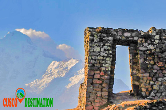
You can visit the architectural complex Choquequirao is situated in Vilcabamba at 3100 meters, considered the last Inka refuge and place of resistance from the invaders, when doing ....
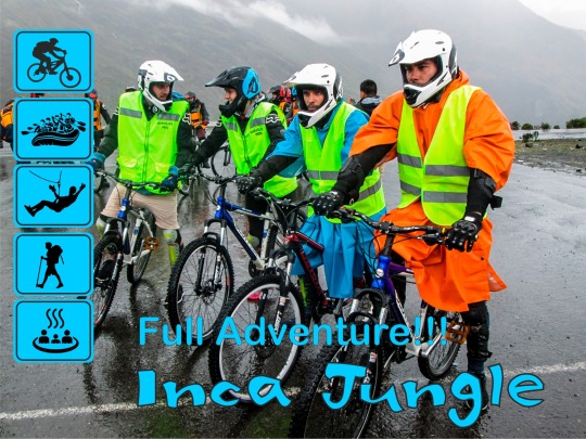
Our Inca Jungle Trail classic To Machu Picchu combines adventure sports such as mountain biking, rafting, zip line, hot spring and trekking for 4 days until you reach Machu Picchu....
In the upper area close to the Skies, the Incas built one of their best-preserved cities, now recognized as one of the 7 wonders of the modern world. Many travelers and adventurers come....
According to the research, the coloration of the rainbow mountain is due to the composition of minerals that it has: the pink color is for the red clay, fangolitas and arilitas. The whitish, for the quartzose ...
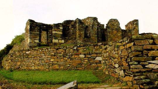
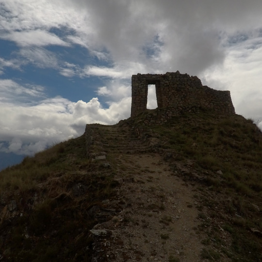
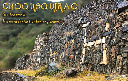
Spectacular and distant, lonely and forgotten, Choquequirao (3,085 masl) is ruled on the top of an almost impregnable mountain in the province of La Convencion, department of Cusco, reason that made it for more than 40 years the last bastion of resistance of The children of the Sun, who sought refuge in their stone walls, after the defeat of Manco Inca, the rebel Inca, will visit palaces, two-level temples, fountain systems, canals, aqueducts, and their admirable "upholstered" profuse platform Vegetation, a place worth the effort. The fatigue yields to the magnificence of Choquequirao.
More Information of Choquequirao Trek
The geographical location is northeast of Cusco between the rivers of Apurimac, Urubamba and the majestic Salkantay with a maximum height of 6,271msnm and a minimum of 2,575 meters above sea level. The Vilcabamba range offers the unique opportunity of a fascinating hike between an environment of glaciers, green mountains, bears, condors, tarantulas, etc. This cloud forest region served as a refuge and natural fortress for the 16th Inca resistance movement of the 16th century, which sought to regain control of the Tahuantinsuyo from Spanish invaders. The customs and clothes typical of local people reflect a mixture of cultures. Its tongue and textiles with Inca and Pre-Inca ornaments, give clear evidence of the influence of the Quechuas. Vilcabamba is also the region where there is a concentration of Pre-Columbian archaeological treasures, including Choquequirao and the famous citadel of Machu Picchu. There is a network of operation of the Inca roads that connects the pampas of Vitcos, Rosas pata and Espiritu Pampa.
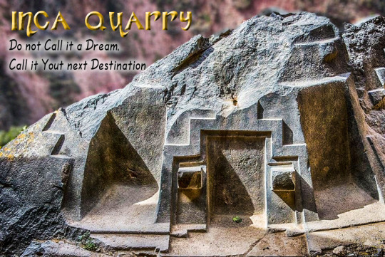
This place was dedicated to the carving and extraction of the stones that were used for the construction of Ollantaytambo and many surrounding precincts. This place is nine kilometers from the Inca town of Ollantaytambo and has three groups of quarries:
Molle Pucro, Sirkusirkuyoc (it was the largest of the three), shows evidence of having been in full operation when the Spanish entered this area. And finally Kantirayoq or Cacchicata, where another type of extraction of minerals and precious stones was practiced. The visitor will be able to observe the great work done when moving the gigantic stones to build the Ollantaytambo enclosures. We can find the so-called "Tired Stones" that stayed during the trip to Ollantaytambo and in some parts of the town.
The Walk to the Cachicata Quarries is located in the Ollantaytambo district, the living Inca city, this wonderful walk will take you to know one of the little known places where the stones were extracted for the construction of the cultivation terraces, temples and The entire archaeological complex of Ollantaytambo. We venture into a route full of beautiful and spectacular views of the sacred valley and the mystical city of Ollantaytambo.
We will take you to know the beauties that the sacred valley hides in all its splendor. We will visit the slopes of Cachiccata, the Paqariqtampu pyramid and the imposing snowfall. It will be an unforgettable experience with the best service provided by our professionals, you will be delighted with such beauty that nature offers us. Those who decide to undertake this cultural journey will return full of the ancestral spirit of the Incas and with a little piece of the Andes in their hearts.
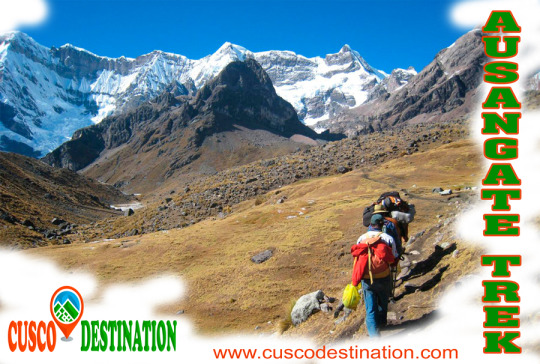
Ausangate Mountain is a natural attraction that is located in the district of Ocongate, within the province of Quispicanchi, in the department of Cusco. That snow is part of the Vilcanota mountain range and, according to an ancient legend, was the brother of Salkantay snow.
The Ausangate Snowy, has a height of 6,384 meters above sea level; and it is considered an apu, or protective deity of the surrounding peoples; as well as the most representative mountain in the region. Its size is such that it can be appreciated even if one is in the Fortress of Sacsayhuamán, not in vain is considered the fifth highest mountain in Peru.
This beautiful snowy Cusco, impresses the eye, for its incredible natural formations; In that one there are not only beautiful mirrors of water such as Sivinicocha, turquoise waters, but also forests of stones, glaciers and high-plains that seem to make this natural attraction a paradise on earth, especially for those tourists who are interested for adventure sports since, the Ausangate landforms make it ideal for sports such as rock climbing, ice climbing, trekking, among other activities. Snowy Ausangate is presented before our eyes as a mountain challenge; it is known, that the first attempts to ascend it were made at the beginning of the fifties of the last century, were the first frustrated attempts to conquer the top of the powerful Apu, it was not until 1953, when a German expedition achieved the goal, climbing the mountain along its southern slope, in posterity, new routes were opened for the conquest of the Apu, however, only in 1983, thirty years after the first ascent, Peruvian feet crowned the top of the majestic snowfall.
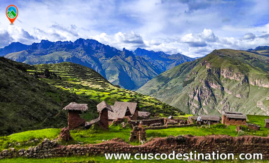
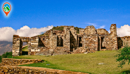
Huchuy Qosqo, Quechua word meaning "little Cusco", is an archaeological complex that is not within the regular package to the Sacred Valley of the Incas, this makes it ideal because it is not crowded like Ollantaytambo and Pisac.
The archeological center of Huchuy Qosqo, is located in the north of the Sacred Valley of the Incas in the immediate vicinity of the province of Calca, district of Cusco. This archaeological complex is one of the most important in the Urubamba valley due to its architectural level, after Ollantaytambo and Pisac. The ruins are impressive, although the conservation of the site is inferior to that of the other two because their constructions are older. The complex includes platforms, courtyards, esplanades, squares, pedestrian path and buildings of different magnitude and quality.
One of the main attractions of Huchuy Qosqo, is a three-story building or levels; The first two are made with finely carved stone and the third level is made of adobe and although it has been lacking a roof for a long time, it is so resistant that it has been standing for more than 500 years.
There are many ways to get there, you can take a taxi from the town of Calca (1 hour from Cusco) to the door of the same complex that is 3550 meters above sea level. The other way is a 5-hour walk from the Laguna de Piray (45 min. From Cusco), where you can enjoy a majestic landscape. This road begins in the town of Cuper, (10min. From the lagoon of Piuray), here the ascent begins until you reach the Abra and from there you follow the Inca trail, which apparently is part of the famous Qapacñay; From here you pass through a beautiful rocky canyon, where you will see the purple, green and red colors of the stones, until you reach the top of the mountain and appreciate the splendor of the Sacred Valley. The road is signposted, but it is always better to ask the muleteers and farmers in the area the exact location of the accesses.
In Huchuy Qosqo you can see an esplanade next to an abyss where you can see Inca constructions, terraces, rooms with up to two floors, canals and everything looks spectacular because they are built on platforms. Huchuy Qosqo Trek to Machu Picchu
The archeological zone of Huchuy Qosqo (Cusco Small), which was known during the Inca period as Qaqyaqawana (which in Spanish means “place from where you see the thunder”), is located in the district of Lamay, within the province of Calca, in the department and region of Cusco, specifically in a plain found on the top of a mountain. At a height of 3 550 meters above sea level. And it is currently considered, thanks to the National Institute of Culture, as Cultural Heritage of the Nation. HUCHUY QOSQO ROUTE TO MACHU PICCHU INFORMATION:
On a historical level, this site is known as the preferred place of the Inca Wiracocha, which he chose as a place of rest and retreat and, where, according to the myth, he died at an advanced age (80 years old). It is also said that this area was already populated by different ethnicities, before the Inca arrival, so they had to be previously defeated. Another striking story about the area is that the Inca Wiracocha had not come only there, but in the company of his son: Inca Urco, the worst ruler of the Empire, who abandoned their Tahuantinsuyo fate after the Chanca attack that ended up being stopped by his other son Cusi Inca Yupanqui. Finally, another reason that makes this site important is the discovery of a mummified body, found during the Conquest, and that would have been attributed to the old Inca monarch, although later burned by Francisco Pizarro's brother.
As for its location, it can be added in addition to the access feature, which provides the visitor (and those who lived in the archaeological center) a great view of the snowy Pitusiray along with the town of Calca.
Regarding the architectural remains that have still been preserved on the site, we can say of them that there are at least 2 buildings, in addition to the presence of platforms and cliffs. Among the buildings, built on the basis of some of stone and others of adobe, we can observe, one of three floors, without name; This first construction is characterized by the presence of the mixture of the construction materials, since the two lower levels are made of carved stone, while the last one preserves adobe-based structure. The second building, also without a name, is a rectangular-based construction, made with adobones, which is believed to have had the purpose of being a space for the labor learning of the women of the Empire. There are also vestiges of remains of smaller enclosures that are almost destroyed due to natural events, including rains and vegetation in the area.
To get to the place the exact location of Huchuy Qosqo is necessary to make a walk, due to the narrow road, it lasts 3 hours from Lamay; on the other hand you can also go from Chinchero, using half a day of pilgrimage; and if you want to make a trip to the site, of longer duration, in which camping is required, you can take the route from the City of Cusco, since this route takes the entire day. The entrance to the site is totally free, although it is recommended that the tourist be done in the company of guides or in groups; Another recommendation is that this tour be carried out in the dry weather period, between the months of April and October, to avoid the slippery area due to the rains.
This complex is the most important archaeological center in the Urubamba Valley, after Ollantaytambo and Pisac. The ruins are impressive, although the conservation of the site is inferior to that of Ollantaytambo or Pisac, because they are older.
But unlike the places mentioned above Huchuy Qosqo has a peculiar architecture: the buildings have been built on polished stone bases of fine finish, with clay plaster (they are the best preserved parts) and the highest floors are made of adobe.
Treks of Huchuy Qosqo Trek
There is a kallanka (rectangular enclosure that could measure up to 70 meters long and that were important state centers where Inca officials were staying) of at least 40 to 50 meters long. Also a remarkable building with two stone floors and an adobe upper one. There are also large terraces, a very wide square and a large Inca gate through which a very well preserved road leads from Tambomachay.
The Hispanic chronicles indicate that Huchuy Qosqo (probably a site known in Inca times as Caquia Jaquijahuana) was the work and favorite place of the Inca Wiracocha. To this, Maria Rostworoski adds, in her work "History of Tahuantinsuyo", that this sovereign strengthened the conquest over the villages of the Urubamba Valley and that he chose as his successor his son Inca Urco who, dizzy from power and vice, He proved to be totally unable to govern. The Inca royalty was very obfuscated with this election and tried to conspire to impose another son of Wiracocha, Prince Cusi Yupanqui. Social unrest and tension increased every day and to make everything worse, the darkest night fell over Cuzco: the Chancas reached the gates of the capital and were willing to destroy it. It is the year of 1438. Wiracocha leaves the city to his fate and, accompanied by his son Inca Urco, takes refuge in its palaces in the Urubamba Valley, among which was Huchuy Qosqo.
After the Hispanic conquest, Gonzalo Pizarro found here the mummy that supposedly belonged to the Inca Wiracocha and ordered it burned. The descendants of the Inca kept the ashes in a jar that many years later the chronicler Polo de Ondegardo would discover.
Characteristics of the visit It is possible to visit Huchuy Qosqo in three ways, the first one walking from Cusco and Tambomachay along the Inca trail. The other way is up from the Sacred Valley after crossing the Wilcamayo River (now Vilcanota) and the Chinchero route.
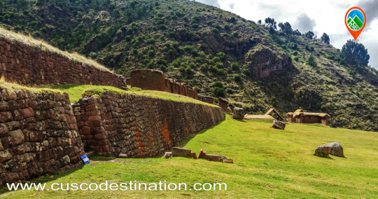
The quarry of Cachicata was the place of extraction of the stones that were used for the construction of Ollantaytambo and many surrounding areas. This place is 9 kilometers from the Inca town of Ollantaytambo and has three groups of quarries: Molle Pucro, Sirkusirkuyoc (it was the largest), shows evidence of having been in full operation when the Spaniards entered this area. And finally Kantirayoq or Cacchicata, where another type of extraction of minerals and precious stones was practiced.
- Starting Altitude - 3350 meters / 10990 feet . - Highest Altitude - 4500m / 14,764ft - Walking Distance - 25 km / 15.5 miles - Meals - 4 breakfast, 3 lunch, 3 dinner, 3 tea times, 3 wake up tea - Overall Difficulty - Moderate - STARTING POINT: - Cusco at your hotel
IMPORTANT INFORMATION:
The Community of Cachiccata consists of 80 families and a total of approximately 300 people. The quarries of Cachiccata is one of the most important attractions, these quarries were widely exploited in the Inca period. From this mine they selected and transported the stones from the archaeological remains of Ollantaytambo. By means of own bearing and thrust techniques, the stones were transferred to this old center. On the way we can see giant semilabrated stones that were being transported. Near the quarries we can also visit some pre-Hispanic chullpas (ancient funerary tower). Machu Picchu is one of the 7 Wonders of the Modern World, Heritage of Humanity, Historical Sanctuary of Peru and probably the most important archaeological site in Latin America. Machu Picchu is majestic architecture comprises 140 structures throughout the citadel. Machu Picchu is was built by the Inca Pachacutec around the year 1460 After being forgotten, it was only in 1911 that the American Hiram Bingham reached Machu Picchu on an expedition and spread the site worldwide.
Brief Itinerary - DAY 1: CUSCO – SOQMA – RAYAN - DAY 2: RAYAN – INTI PUNKU – CHOQUETACARPO - DAY 3: CHOQUETACARPO – OLLANTAYTAMBO – AGUAS CALIENTES - DAY 4: MACHU PICCHU - CUSCO
Ollantaytambo is another of the many places where we can admire the archaeological wealth that the Incas left us. It is a population that is part of the province of Urubamba and the department of Cusco.
It is located at the convergence of two valleys crossed by the Vilcanota, which the Incas called Willcamayu (Sacred River) and the Patacancha. At an altitude of 2,790 m.a.s.l.
One of the routes I do frequently, is towards the Inca quarries of Cachiccata. The last ascents I have initiated from the Inca bridge that is at the entrance of Ollantaytambo coming from Urubamba. This bridge consists of two eyes over the Vilcanota River (or Urubamba River). Its bases, of Inca origin, are made up of large blocks of stone and, to protect the central pillar, they placed two huge rocks as a water-breaker in the course of the river. In its origin, this bridge must have been a suspension, and like so many others that the Incas did, it was made with the braiding of a plant called “ichu”, which is still used today on the roof of many Andean houses.
INFORMATION OF INCA QUARRY TREK
Once across the bridge, the ascent begins on the left bank. A sign shows us the route to follow, while we have a good view of the platforms that surround Ollantaytambo.
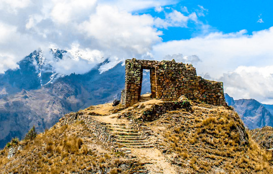
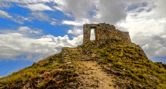
In front of the train station we will encounter a rocky ledge on which there are the ruins of a control or defensive fort known as Choquequillca. On the other side of the Vilcanota River (right bank) we found no fortification, perhaps because it was destroyed with the layout of the railway. Our goal is to visit the Cachiccata quarries and then continue the ascent to the top of the Arequipa Hill, where there is an Inca archaeological structure, known as INTI-PUNKU (Puerta del Sol). The distance between the Inca bridge of Ollantaytambo and the INTI-PUNKU is about 8 km with 300 m. following a pedestrian trail. This journey can be done in one day without trying to break records. It is convenient to get up early to avoid the intense midday sun.
The initial road runs parallel to the Vilcanota River, with terraces on the left side. In front, on the other side of the river, we can contemplate another architectural group of the Inca culture; It is called Raqaypata.
A second part of the road, much wider, takes us to the bottom of the Cachiccata quarry (in Quechua it means “salt slope”). It is a continuous ascent to save the 400 m. of unevenness between the starting point (2800 m altitude on the Ollantaytambo bridge) and this lower quarry located at 3210 m.a.s.l.
Along this second journey, which is one of the ramps through which the Incas slid the pink stone blocks, we found some of these large stones that did not reach their destination and are known as “ Tired Stones. "
Here are two copies: the first one is located in front of the church of San Santiago Apostol (Ollantaytambo) and the second one is found on the way up to the quarry.
It is not uncommon to find tour groups accompanied by a guide, and pack animals transporting the materials of a long journey. It is also common to find people picking aromatic or medicinal plants (muña, tara, ...) It is obligatory for me, when visiting these places, to visit Don Guillermo Qawa; an old man who lives alone at 3022 m altitude and with whom I share a “little time” of company and some food, every time I make this route.
Why not mention the children Francisco, Roqui, Yéssica, Lourdes and Lisbeth to whom on this last walk we offered the promised toys?
The Cachiccata quarries are located under the impressive Black Good Apu from which the Incas extracted the huge blocks of pink rhyolite. These stones were partially worked in the quarries and then down to the Vilcanota River in front of the Rumira sector.
Through an artificial channel parallel to the riverbed, they diverted the water alternately (in times of drought) and thus moved the blocks on either channel with an island in the middle. The blocks were dragged back to the fortress of Ollantaytambo.
The last section consisted of a steep ramp, which can be seen perfectly from the left bank of the river, as shown by the arrow in the photograph. We know, from the tools that the Incas abandoned in the quarry, that they used the same stone for the extraction of the blocks: granite and basalt strikers, obtained in the Vilcanota River. These quarries had to be abandoned when Manco Inca retired from Ollantaytambo.
The last section consisted of a steep ramp, which can be seen perfectly from the left bank of the river, as shown by the arrow in the photograph. We know, from the tools that the Incas abandoned in the quarry, that they used the same stone for the extraction of the blocks: granite and basalt strikers, obtained in the Vilcanota River. These quarries had to be abandoned when Manco Inca retired from Ollantaytambo.
As for the transfer of the immense stones, we do not stop questioning the time, the way and the enormous amount of people contributing their strength and ingenuity. There is no doubt that the Inca people were construction experts; his numerous works that still endure so testify: Coricancha, Sacsayhuamán, Ollantaytambo, etc.
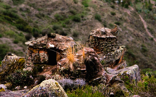
In the northern (lower) quarry of Cachiccata there are small constructions known as “CHULLPAS”. They are tiny towers of circular base, built with stones joined with mortar of red mud and straw. These are funerary constructions that abound in the Highlands of Peru and Bolivia, typical of the Qollas.
Those of Cachiccata, due to their small size, we deduce that they served as burial for a single person, in which they generally placed the deceased in fetal form along with some of their belongings. They have an opening or entrance in a rectangular shape and have the upper part or roof covered. Some are very damaged and others have completely disappeared; all have been looted by treasure hunters (Huaqueros).
At our feet is the small town that gives name to these quarries: CACHICCATA. A peasant community of about 80 families with approximately 320 people living on agriculture, especially corn and potatoes.
After replenishing forces, we continue the ascent to the west and south quarries. In both we find stones of greater size and better worked, as well as a limited enclosure in which the stones extracted from the quarry were stored and worked. From this place we can contemplate a spectacular landscape: · The wide valley crossed by the Vilcanota river with its diverse green tones, characteristic of the rainy months; and in the middle, the famous pyramid of Paccarectampu. Regarding this truncated pyramid of Ollantaytambo, certain writings relate it to the founding beginnings of the Inca Empire. What we can confirm is that during the winter solstice (June 21), with the sunrise, it is possible to observe different light effects through solar projections on this pyramid of Ollantaytambo.
· Al Al frete, the imposing peaks of the Vilcanota Range, among which the Apu (divinity) or Veronica Snow also known as Wakaywilque with its 5,682 m.a.s.l. struggling to peek her white hair between the clouds that surround her.
I was surprised to find in these quarries a stone wheel (like an old mill) apparently unfinished, because the central hole was completely unperforated.
Continuing our ascent, the next stop was at the archaeological remains of Choquetacarpo located at 3,495 m.s.n.m, of which we do not know the purpose they had, although it seems to have been the residence of those who managed the quarry.
The trip continues in its last stage of ascent until reaching 3,943 m.a.s.l. With your eyes fixed on the INTI-PUNKU (Puerta del Sol) and the desire to complete the feat of reaching that altitude, forces arise under the intense sun and dizziness from the height. MACHU PICCHU TOUR
They are the last meters, some steps and we access the Puerta del Sol. An impressive spectacle appears before our eyes. Mute and contemplate is the most appropriate. Praise be my Lord!
Inca quarry "Cachicata"
This place was dedicated to the extraction and carving of the stones that were used for the construction of Ollantaytambo and many surrounding precincts. This place is located about 14 km from the Inca town of Ollantaytambo and has three groups of quarries: Molle Pucro, Sirkusirkuyoc (it was the largest of the three), shows the evidence of having been fully operational when the Spanish arrived in this area . And finally Cacchicata or Kantirayoq, where another type of extraction of minerals and precious stones was practiced. Visitors can observe the great work done at the time of moving the giant stones to build Ollantaytambo enclosures. We can find the stones called "Tired Stones" that were on their way to Ollantaytambo and in some parts of the city.
Cachicata or Inca quarry is one of the old quarries used by the pre Inca and Inca civilizations to build the vast complexes of Ollantaytambo. It was a source of large amounts of pink granite. The Cachicata quarries are 14 km from Ollantaytambo. The view of Ollantaytambo from the quarries is spectacular and during the walk you can see many large stones that remained in the middle of their long trip to the village. It was also a commercial route for the Incas. Cachicata is a small and remote town that can benefit from the occasional visit of tourists.
The Hike to Cachicata is a great alternative to the famous Inca Trail hike. This road was built by the Incas and used for hundreds of years to access local communities and transport goods. This trail is not as well known as the Classic Inca Trail, so much less crowds and a more serene trekking experience in Peru are expected. This hiking adventure not only visits Peru's cultural past, but also explores modern Inca communities and customs. The trail takes us through isolated waterfalls, ancient terraces and exotic wildlife, while offering fantastic views of the Sacred Valley and its snowy mountains. Visit with local families and explore an active quarry. Each step brings a new look to the Inca culture.
How long is Ollantaytambo?
The trip from the city of Cusco to the Inca city of Ollantaytambo is approximately 1 hour and 30 minutes in private mobility but if you wish to travel in the public transport units the approximate time is 2 hours.
Can you climb to the Inca quarry of Cachicata without a guide?
The Walk to the Inca quarry of Cachicata to be part of the circuit of Inca roads that runs through the country of Peru, and the circuit of Qhapap Ñan, it is recommended that it be carried out with the supervision of an authorized agency that provides the professional guide service so that you can enjoy the best way to hike and take a nice memory to your country.
How high is Inti Punku "Puerta del Sol"?
Inti Punku or «Puerta de Sol» is the highest point on the hike to the Inca quarry being at a height of approximately 3886 meters from that point you can see an impressive view of the Sacred Valley and the Snowfall that are around as are the snow Veronica.
What should I take to make the walk to the Inca quarry of Cachicata?
To make the walk without any inconvenience we recommend the following:
A lightweight backpack to carry your stuff.
Water bottle.
Money for snacks, souvenirs and tips if you want to tip.
Hat, sunscreen and sunglasses
Jumper (sweater)
Protection against rain (or plastic poncho) the Cusco region can experience «all seasons in one day», therefore, it is advisable to wear a hat and gloves, as well as a sun hat, when going out tomorrow, in order to be prepared for all eventualities.
Is a tourist ticket needed for the Inca Quarry of Cachicata?
At the moment no income is being collected, which will allow him to discover with greater freedom the path of the Incas to the Inca quarries of Cachicata.
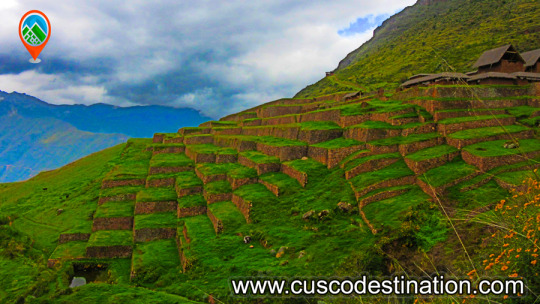
Choquequirao known as the sacred sister of Machu Picchu because it has a structural and architectural similarity, the archaeological monuments are made up of terraces distributed at different levels which were leveled and fenced with stones to form a platform with an area of approximately 150 square meters.
More Information: Choquequirao Trek
Location The ruins of Choquequirao are located at 13 ° 32 ’latitude and 77 ° 44’ west longitude, it is located 3033 meters above sea level in the snowy mountains of Salkantay north of the Apurimac river in the district of Santa Teresa province of the convention department of Cusco.
How to get Currently to reach the last Inca fortress is the land route, the best known route of how to get to Choquequirao is taking the road to Abancay, and at km 154 choose the detour that will lead you to the town of Cachora.
The route to Choquequirao has narrow roads which you have to walk very carefully, also have a good physical condition and the appropriate equipment for this walk.
Weather Due to its height, Choquequirao enjoys a mild climate. However, it is necessary to highlight that the Choquequirao road is warm due to the Apurimac canyon.
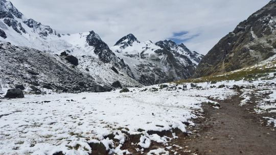
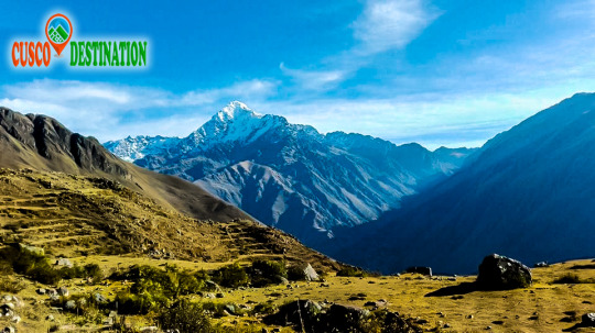
Salcantay located in the Cordillera Vilcabamba, department of Cusco, rises to 6271 meters above sea level.
The Salkantay is the Apu and tutelary snow of Cusco.
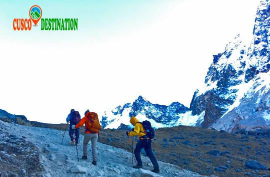
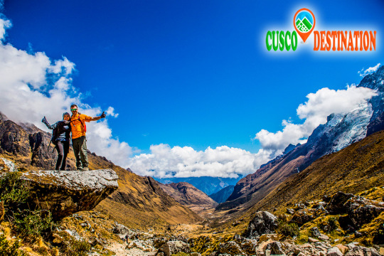
To get to it, you will cross beautiful Andean landscapes, open 5,000 meters. and the possibility of observing Condors and Alpacas in their natural habitat. You can take baths in natural hot springs from the depths of the earth, different fruit plants and a variety of orchids. More Information Salkantay Trek.
The Cordillera de Vilcabamba, where the Salcantay massif is located, is a beautiful and lonely area. Dominated by the same Apu Salcantay has numerous high-elevation snowfalls, such as Tucarhuay (5,910 m.a.s.l.), Veronica (5,682 m.a.s.l.) and Huacayhuilca (5,361 m.a.s.l.), among others.
All of them are visible from the Puyupatamarca area during the Inca Trail to Machu Picchu. Geography is difficult and capricious around the contour of this attractive mountain complex. The Salkantay is surrounded by deep valleys and gorges, which makes its tour interesting but at the same time exhausting.
Although the difficulty of this Trek is slightly higher than that of the Inca Trail, it is not a high level Trek. Indeed, it is longer (5 days instead of 4), taller, more wild but there is also your interest.
This Trek does not disappoint the most demanding or lovers of nature, hiking, emotions; those same emotions that make him feel invulnerable, only in the world, on the roof of the world, in a nutshell ... feel alive!
To make the excursion you must contact a specialized tourism agency. Cusco Destination
What does Salkantay mean?
The Salkantay is a snowy whose name translated from Quechua would mean ‘Wild Mountain’. This summit is known as ‘Apu’ (‘Lord’) for its majesty and elevation.
Where is it located?
The pu Apu ’Salkantay is located in the Vilcanota Mountain Range in the Andes of southern Peru. This snow is the second largest in Cusco, after Ausangate (Mountain of the 7 Colors). How high is the snowy Salkantay?
The snowy Salkantay reaches 6,271 meters above sea level (m.s.n.m.). The trek route that leads to Machu Picchu has its highest point at ‘Abra Salcantay’, at 4,650 m.a.s.l. From there you can see the snowy peak. How's the weather?
The snow itself has an extremely cold climate (several degrees Celsius below 0º).
The weather during the Salkantay trek, however, is varied. The intense sun and the cold night in the first days change for the tropical atmosphere of the last. How is the flora and fauna?
The 5 days and 4 nights that the Salkantay trek lasts runs landscapes with a great variety of flora and fauna. Among the species of flowers and plants, the orchid and ichu (Andean grass) stand out. Among the species of birds and animals, it is worth mentioning the llama, alpaca, vizcacha, condor, spectacled bear and the cock of the rocks (national bird of Peru)
Salkantay trek: everything you need to know
What is the Salkantay trek?
The Salkantay trek is a hiking route that takes the visitor to the Inca City of Machu Picchu. The total walking distance is approximately 70 kilometers (5 days of route).
The Salkantay trek is considered among the 25 best excursions in the world by the National Geographic Adventure Travel Magazine.
SALKANTAY TREK CHALLENGE ITINERARY
DAY 1: Cusco – Soraypampa – Salkantay Pass – Chaullay.
We’ll leave the city of Cusco at 04:00 a.m. we’ll pick you up from your hotel, and transport you for about 3 hours to Mollepata where we’ll stop for our breakfast and purchase some items for the trek, then, we’ll continue one hour drive to Soraypampa where we’ll start our hike. As soon as we are at Soraypampa, we’ll start hiking the first 3 hours will be uphill to get to the Highest Point which is at 4,600 masl (the highest of the trek) Afterwards we’ll follow a rocky serpentine trail down to the village of Huayracmachay and we’ll have lunch. In the afternoon, we descend further into a lush tropical ecosystem, the high Jungle; the temperature increasing as we go, We will walk until we reach our camp in Chaullay.
DAY 2: Chaullay - La Playa - Aguas Calientes
You will hike through the jungle are of Santa Teresa. The valley is formed by the salkantay river that discures from the white mountain. In this valley you have the opportunity to see waterfalls, rivers, plantations like coca, coffee, avocado, passion fruit, bananas and much more is a tropical valley and the climate is quite warm. After of our breakfast we will start the trek to the town of sahuayco, after 5 hours of crossing through the dense vegetation we arrived at the lunch point. After our lunch we will board a bus that will take us to Hidroelectrica, we will hike 3 hours more to aguas calientes town on the flat trail. Then we take you to the hotel for showering and relaxing, in the evening around 7:00 pm we organised a dinner in a restaurant in Aguas Calientes after dinner we go to sleep to climb Machu Picchu early on the next day.
DAY 3: MACHU PICCHU - CUSCO
After an early breakfast at the hotel, we walk uphill to Machu Picchu at 5:00 am. or take the bus from Aguas Calientes to Machu Picchu (Optional bus $16 each way), upon arrival at the Citadel we can appreciate the enigmatic beauty and the incomparable example of architectural perfection and hydraulics of one of the 7 Wonders of the Modern World, we will have a guided tour of about 2 hours, where we can appreciate the Main Plaza, the Circular Tower, Intihuatana, The Royal Quarters, the Temple of the Three Windows and the Cemetery, you are then given free time to stroll around the citadel . You will have all morning in Machu Picchu to take pictures, maybe to climb the Wayna Picchu or Machu Picchu Mountain, enjoy this mystical place. Then we´ll descend by bus to Aguas Calientes for lunch and then calmly return by train to Ollantaytambo where our tourist transport to the city of Cusco will be expecting us, and will later transfer you to your hotel. OTHER ACTIVITIES:
Climb up Huayna Picchu and appreciate the beauty and magnificence of Machu Picchu from there (We recommend that you book in advance) Not Included
Climb Machu Picchu Mountain and appreciate the beauty and magnificence of Machu Picchu from there (We recommend that you book in advance) Not Included
Visit the new local museum or the hot springs in Aguas Calientes later in the day. Not Included
- Meals: Breakfast - Tour: 2 hour guided tour of Machu Picchu
The Hot Springs of Santa Teresa are the most beautiful in Cusco. They are immersed in nature, on the banks of the Urubamba River and at the foot of the mountain.
A unique experience to enjoy during your trip to Cusco, where you can relax your body and mind while contemplating the native landscape.
The hot springs of Santa Teresa are located in Cocalmayo, Sacred Valley of the Incas, Cusco. The thermal complex, located at a height of 1,600 m.a.s.l., is built on the slopes of the mountain and on the banks of the Urubamba River. A unique space, where visitors enjoy a pleasant moment immersed in the warm waters of Santa Teresa while contemplating a unique natural beauty.
The thermal baths of Santa Teresa are conformed by three pools of different sizes and depths, which are supplied with medicinal water that varies between 40ºC and 44ºC. Medicinal waters have healing properties to treat skin ulcers, bone pain and rheumatism.
The Santa Teresa Hot Springs pools are surrounded by nature. Its bottom is composed of soft sand and is surrounded by rocks, vegetation, the sound of the Urubamba River and the mountain. Near the pools, there are jets of cold water coming from the Uripata lagoons, which provide a very pleasant feeling. And a hydromassage system.
The Santa Teresa hot springs are fully equipped with bathrooms, showers, dressing rooms, soccer fields, camping space, cafeteria, kiosk (where visitors can buy food and drinks) and a viewpoint. It is a very nice place to rest after visiting the ruins of Machu Picchu, the Inca roads, Choquequirao and other tours in Cusco.
The hot springs are open every day of the year, almost 24 hours a day. Its wide time slot allows you to enjoy the starry nights inside the pools, which is amazing since the stars are reflected in the crystal clear water as if it were a mirror.
Chemical composition of the water in the Santa Teresa hot springs: The thermal baths of Santa Teresa differ from the other thermal waters of Peru by their crystalline waters. The thermal waters of Cocalmayo or Santa Teresa are composed of minerals such as calcium, sodium, bicarbonate, sulfate, magnesium, among others.
TRAVEL TYPE! Do not forget to bring mosquito repellent to your visit to the Hot Springs of Santa Teresa. Nature gives us a unique and unique setting in these medicinal waters, but also presents the typical insects of the jungle areas. With a repellent you will avoid small mosquito bites. How to get to the hot springs of Santa Teresa? The Hot Springs of Santa Teresa (or Cocalmayo, as many know them) are located at kilometer 135 of the former Cusco - Quillabamba railway line, on the left bank of the Urubamba River.
To get to the thermal baths from the city of Cusco you can choose to do it by bus, bicycle, motorcycle, train or quadricycle. By Bus from Cusco to Santa Teresa You must go to the Cruz del Sur - Santiago bus terminal, in the city of Cusco. There, take the bus that goes to the district of Santa María. This journey (Cusco City - Santa María) lasts approximately 5 hours.
Once in the town of Santa María, take a taxi or a means of transport to Santa Teresa. The duration is approximately one hour. Having arrived in the town of Santa Teresa, walk for 20 minutes to the thermal baths or take a taxi whose journey lasts only 10 minutes. By train from Cusco to Santa Teresa Go to the San Pedro train station, in the city of Cusco. Get off at the end of the tour, at the hydroelectric power station.
From there take a taxi, combi or walk to the Plaza de Armas de Santa Teresa. From this place, return to take a shuttle service to the thermal baths (this last journey takes approximately 10 minutes). While if you want to do it walking, it will last approximately 20 minutes.
If you want to reach the thermal baths of Santa Teresa from the hydroelectric power station, you should know that the journey will take approximately 2 hours. By train from Ollantaytambo to Santa Teresa If you are in Ollantaytambo and bought your train ticket to Machu Picchu, get off at the hydroelectric power station and, as it says in the previous point, take a taxi or patch up to Santa Teresa (20 minutes) Or walk to the thermal baths about 2 hours . By bike or motorcycle to Santa Teresa Some tour operators offer bike tours as part of their Adventure Tourism program. Usually, the tours last 4 days. inca jungle It starts from the city of Cusco to Ollantaytambo, then to the Abra de Malaga reserve, located at 4,350 m.a.s.l. surrounding the snowy Urubamba and continue to the district of Santa María.
The next day, the trip continues to Santa Teresa where you can enjoy the hot spring night. The tour ends in Machu Picchu Pueblo to visit the ruins of Machu Picchu the next day.
This excursion is also done by motorcycle, in this case the duration of the tour is shorter. The best time to visit the thermal baths of Santa Teresa The best time to go to the Hot Springs of Santa Teresa (Cocalmayo) is during the months of April to October. Santa Teresa in recent years has grown quite a lot due to the investments that have been made in accommodation, restaurants and other tourist services.
Santa Teresa - Cocalmayo Hot Springs prices The values of the tickets to the Termas de Santa Teresa in Cusco belong to the 2018 tariff. Foreign adult ……………………… S /. 10 National adult …………………………. S /. 5 Local Adult ………………………………. S /. 2.50
Because of its altitude, Choquequirao has a temperate climate. However, it should be noted that the road to Choquequirao is warm because of the Apurimac canyon.
Choquequirao was presumably used as a control site to ensure access to areas of Vilcabamba, connecting the jungle with other major centers like Pisac and Machu Picchu. The archaeological remains of Choquequirao are comprised of buildings and terraces on different levels, in which their terraces stand out due to 22 carvings on stone with figures known as "Llamas del Sol" arranged in 15 platforms towards the snowy Qori Hauyrachina. Choquequirao features a large system of platforms/terraces.
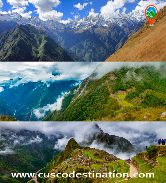
Machu Picchu is one of the 7 Wonders of the Modern World, Heritage of Humanity, Historical Sanctuary of Peruand probably the most important archaeological site in Latin America. Its majestic architecture comprises 140 structures throughout the citadel. It was built by the Inca Pachacutec around the year 1460. After being forgotten, it was only in 1911 that the American Hiram Bingham reached Machu Picchu on an expedition and spread the site worldwide. Its main buildings are the Intihuatana, the Temple of the Sun and the Temple of the Three Windows. In 1913 it received worldwide attention when the National Geographic Society dedicated its entire print run in April to the newly rediscovered city.
Brief Itinerary - Day 1: CUSCO - CACHORA - COCAMASANA - PLAYA ROSALINA. - Day 2: PLAYA ROSALINA – CHOQUEQUIRAO. - Day 3: CHOQUEQUIRAO - PINCHINUYOC - Day 4: PINCHINUYOC – RIO BLANCO - MAIZAL. - Day 5: MAIZAL - YANAMA - DRIVE TO LUCMABAMBA. - Day 6: LUCMABAMBA - LLACTAPATA - AGUAS CALIENTES. - Day 7: MACHU PICCHU - CUSCO.
Día 1: Cusco - Cachora - Chiquiska. Lo recogeremos en su hotel en un bus privado. Partimos de Cusco, luego nos dirigimos a la ciudad de Cachora (3100 msnm), aquí encontramos los transportistas y el personal de apoyo, en Cachora comenzaremos nuestra caminata, después de 2 horas de caminata llegaremos a Capuliyoc (2915 m) desde allí. Tendremos una hermosa vista de los picos nevados Padrayoc, Wayna Cachora y el valle de Apurimac. Luego descenderemos hacia la Coca Masana (2330 m) donde el clima se vuelve más cálido y la flora y la fauna comienzan a cambiar. Finalmente llegaremos a nuestro primer campamento en el oasis de Chiquiska (1950 metros / 6000 pies).
- Comidas: Almuerzo, Cena - Acomodación: Campamento, Chiquiska 1950 msnm - Clima: cálido y soleado - Distancia recorrida: aproximadamente 10 km - Tiempo de caminata: 6 horas Día 2: Chiquiska - Choquequirao. Este día es el más difícil de los cinco días, nos levantaremos muy temprano. Después del desayuno, continuaremos nuestro descenso hacia Playa Rosalinda, donde cruzaremos el río Apurímac (1495 metros / 5000 pies). Desde aquí comenzaremos nuestra caminata por un camino empinado durante aproximadamente 5 horas hasta llegar a Raqaypata donde almorzaremos. A lo largo del paseo observaremos muchas orquídeas y flores silvestres, muchas aves. Desde Raqaypata caminaremos durante aproximadamente dos horas hasta el sitio arqueológico de Choquequirao y allí observaremos la puesta de sol y el vuelo del cóndor. Nuestro campamento se instalará fuera de las ruinas.
- Comidas: desayuno, almuerzo, cena - Acomodación: Campamento, Choquekiraw 3100 msnm - Clima: cálido y ventoso - Distancia recorrida: aproximadamente 13 km - Tiempo de caminata: 7 horas Día 3: Choquequirao
We dedicate this day to explore the ruins of Choquequirao. Our guide will explain the history and importance of this archaeological complex. You will then have free time to visit different areas of the archaeological complex. Much work has been done in recent years to excavate, clear and restore the site. After lunch, those who choose to can visit the Cascade House(restored buildings and terraces some 300 meters (1000 feet) below the main structures of Choquequirao). Later, our evening meal will consist of a typical Peruvian “pachamanca” (traditional Andean ingredients cooked in the earth). Volunteers to help with the preparation will be welcome! From the highest point of the archaeological site (the “usno”, or ceremonial platform) there are fine views of the Apurimac canyonfar below, and if we are fortunate we may even see a great Andean condor soar above us.
- Comidas: desayuno, almuerzo, cena - Acomodación: Campamento, Choquekiraw 3100 msnm - Clima: cálido y soleado - Distancia recorrida: aproximadamente 10 km - Tiempo de caminata: 7 horas Día 4: Choquequirao - Coca Masana. Después del desayuno continuamos nuestra ardua caminata de regreso por un sendero empinado hacia el río Apurimac, donde nos detendremos y almorzaremos. Por la tarde subiremos unas 4 horas para llegar a Coca Masana. Allí cenaremos y acamparemos.
- Comidas: Desayuno, Almuerzo, Cena - Clima: cálido y soleado - Acomodación: Campamento, Cocamazana 2300msnm. - Distancia recorrida: aproximadamente 14 km - Tiempo de caminata: 8 horas Día 5: Coca Masana - Cachora - Cusco. Después del desayuno, regresamos por el mismo camino hasta el paso de Capuliyoc y desde aquí son dos horas más hasta el pueblo de Cachora. Luego tomamos el autobús que nos llevará a Cusco
- Comidas: Desayuno - Clima: cálido y soleado - Distancia recorrida: aproximadamente 9 km - Tiempo de caminata: 6 horas
You can visit the architectural complex Choquequirao is situated in Vilcabamba at 3100 meters, considered the last Inka refuge and place of resistance from the invaders, when doing this trek you will enjoy beautiful scenery, you'll see the impressive Apurimac Canyon, flora and wildlife along the path. This route offers a strenuous but formidable journey due to the various existing ecosystems.
Useful Information
- Starting Altitude - 2900m / 9515ft. - Highest Altitude - 3050m / 10,005ft - Walking Distance - 64 km / 40 miles - Longest Day - Day 1, approximately 25 km/15.5 miles - Overall Difficulty - Difficult
IMPORTANT INFORMATION:
Because of its altitude, Choquequirao has a temperate climate. However, it should be noted that the road to Choquequirao is warm because of the Apurimac canyon. Choquequirao was presumably used as a control site to ensure access to areas of Vilcabamba, connecting the jungle with other major centers like Pisac and Machu Picchu. The archaeological remains of Choquequirao are comprised of buildings and terraces on different levels, in which their terraces stand out due to 22 carvings on stone with figures known as "Llamas del Sol" arranged in 15 platforms towards the snowy Qori Hauyrachina. Choquequirao features a large system of platforms/terraces.
Brief Itinerary - Day 1: Cusco – Cachora – Capuliyoc – Santa Rosa - Day 2: Santa Rosa – Marampata – Choquequirao. - Day 3: Choquequirao – Marampata – Chiquisca. - Day 4: Chiquisqa – Capuliyoc – Cusco.
The quarry of Cachicata was the place of extraction of the stones that were used for the construction of Ollantaytambo and many surrounding areas. This place is 9 kilometers from the Inca town of Ollantaytambo and has three groups of quarries: Molle Pucro, Sirkusirkuyoc (it was the largest), shows evidence of having been in full operation when the Spaniards entered this area. And finally Kantirayoq or Cacchicata, where another type of extraction of minerals and precious stones was practiced.
Useful Information
- Starting Altitude - 3350 meters / 10990 feet . - Highest Altitude - 4500m / 14,764ft - Walking Distance - 25 km / 15.5 miles - Meals - 4 breakfast, 3 lunch, 3 dinner, 3 tea times, 3 wake up tea - Overall Difficulty - Moderate - STARTING POINT: - Cusco at your hotel
IMPORTANT INFORMATION:
The Community of Cachiccata consists of 80 families and a total of approximately 300 people. The quarries of Cachiccata is one of the most important attractions, these quarries were widely exploited in the Inca period. From this mine they selected and transported the stones from the archaeological remains of Ollantaytambo. By means of own bearing and thrust techniques, the stones were transferred to this old center. On the way we can see giant semilabrated stones that were being transported. Near the quarries we can also visit some pre-Hispanic chullpas (ancient funerary tower). Machu Picchu is one of the 7 Wonders of the Modern World, Heritage of Humanity, Historical Sanctuary of Peru and probably the most important archaeological site in Latin America. Machu Picchu is majestic architecture comprises 140 structures throughout the citadel. Machu Picchu is was built by the Inca Pachacutec around the year 1460 After being forgotten, it was only in 1911 that the American Hiram Bingham reached Machu Picchu on an expedition and spread the site worldwide.
Brief Itinerary - DAY 1: CUSCO – SOQMA – RAYAN - DAY 2: RAYAN – INTI PUNKU – CHOQUETACARPO - DAY 3: CHOQUETACARPO – OLLANTAYTAMBO – AGUAS CALIENTES - DAY 4: MACHU PICCHU - CUSCO
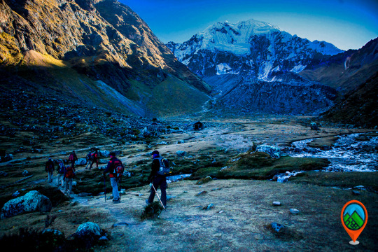
INFORMATION OF SALKANTAY TO MACHU PICCHU Salkantay is a snow-capped mountain in Peru located in the department of Cuzco; It is one of the main peaks of the Vilcabamba mountain range. It reaches an altitude of 6,271 meters. It presents two summits covered by snow. The Salkantay Route, also known as the " New Inca Trail", is located north of the city of Cusco, following the Cusco - Limatambo highway, making a detour past Limatambo until you reach Mollepata.
It is very sunny during the day, but a cold at night. The temperature falls below 0 ° C at night during the months of June to September. In the season from December to March it is very rainy reason why it is not recommended to go on these dates. The best time for the weather, to do this walk is during the months of March to September. This hike reaches a height of 4,600 meters above sea level at its highest point this on the slopes of the same snowy Salkantay. The buses from Cusco to Mollepata depart very early from 4:00 to 5:00 and go through Limatambo, from Mollepata is where the trek to the snowy Salkantay starts, after climbing a step up it is possible to have an impressive pyramidal view of the Salkantay, one of the most beautiful snows of Cusco. From the same Mollepata it takes two days to go down to Huayllabamba and merge with the second day of the Inca Trail. On the way there are herds of cattle and sheep, orchids, bear with glasses, medicinal plants of the Inca eponca, small variety of birds, fruit trees such as Orange, Papaya, bananas, etc. - Note: The spectacled bear to see it you have to have a bit of luck.
If you want to visit this Inca Citadel we have the trek for you: Salkantay Trek Challenge, Salkantay Trek Express,Salkantay Trek classic.
Salkantay trek challenge 3 days is considered by most to be the best and challenging alternative route to Machu Picchu, This walk allows you to enjoy the options that there is in the salkantay route, you will pass for the highets point of the salkantay route to be to see salkantay mountain up close, you hike through the santa teresa valley that is full of vegetation is the begining of the peruvian amazon, you have the chance to see, plantations of coffe, coca, avocados, bananas and much more, this valley is full of fresh wáter with many waterfalls.
Useful Information
- Starting Altitude - 3350 meters / 10990 feet . - Highest Altitude - 4600 meters / 15091 ft - Walking Distance - 12km / 7.45 miles - Campsite Elevation - 3920 meters / 12861 ft - Meals - 2 breakfast, 2 lunch, 2 dinner, 1 tea times, 1 wake up tea - Overall Difficulty - Changing - STARTING POINT: - Cusco at your hotel
IMPORTANT INFORMATION:
The snow-capped Salkantay is one of the highest mountains in Cusco, along with the Ausangate mountain in the Vilcanota mountain range which is located further south. The Salkantay Trek to Machu Picchu is listed as one of the 25 best treks in the world by National Geographic Adventure Travel Magazine. The Salkantay Trek is definitely one of the very best trekking adventures that you will find in Cusco and in Peru. After the Inca Trail classic or Inca Trail short, the Salkantay route is the 2nd most popular to Machu Picchu (and a lot less crowded). Machu Picchu is one of the 7 Wonders of the Modern World, Heritage of Humanity, Historical Sanctuary of Peru and probably the most important archaeological site in Latin America. Machu Picchu is majestic architecture comprises 140 structures throughout the citadel. Machu Picchu is was built by the Inca Pachacutec around the year 1460 After being forgotten, it was only in 1911 that the American Hiram Bingham reached Machu Picchu on an expedition and spread the site worldwide.
Brief Itinerary - Day 1: Cusco – Soraypampa – Salkantay Pass – Chaullay. - DAY 2: Chaullay - La Playa - Aguas Calientes - DAY 3: MACHU PICCHU - CUSCO
CHOQUEQUIRAO TREK
You can visit the architectural complex Choquequirao is situated in Vilcabamba at 3100 meters, considered the last Inka refuge and place of resistance from the invaders, when doing this trek you will enjoy beautiful scenery, you'll see the impressive Apurimac Canyon, flora and wildlife along the path. This route offers a strenuous but formidable journey due to the various existing ecosystems.
Useful Information
- Starting Altitude - 2900m / 9515ft. - Highest Altitude - 3050m / 10,005ft - Walking Distance - 64 km / 40 miles - Longest Day - Day 1, approximately 25 km/15.5 miles - Overall Difficulty - Difficult
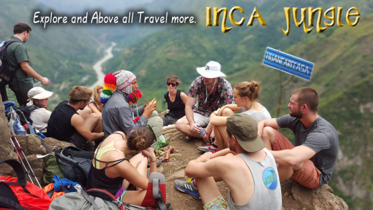
INCA JUNGLE TO MACHU PICCHU
Our Inca Jungle Trail classic To Machu Picchu combines adventure sports such as mountain biking, rafting, zip line, hot spring and trekking for 4 days until you reach Machu Picchu and one of the additional mountains "Machu Picchu Mountain" or "Huaynapicchu". The Inca Jungle route is the favorite tour for young people from all over the world who come to Cusco in search of deferent adventures and extreme sports. As a Tourism Agency located in Cusco we offer a differentiated service; with an exclusive route, trained guides (real command of English, local history and adventure sports), bicycles equipped for downhill, the safest rafting and zipline services. We recommend our passengers book in advance to have everything insured and avoid unnecessary risks such as loss of equipment, lack of access to Machu Picchu, Machu Picchu Mountain, Huayna Picchu or even worse, being stranded in Aguas Calientes (no return train). This tour is one of the classic routes full of adrenaline to the Inca citadel of Machu Picchu.
INCA QAURRY TREK TO MACHU PICCHU
The quarry of Cachicata was the place of extraction of the stones that were used for the construction of Ollantaytambo and many surrounding areas. This place is 9 kilometers from the Inca town of Ollantaytambo and has three groups of quarries: Molle Pucro, Sirkusirkuyoc (it was the largest), shows evidence of having been in full operation when the Spaniards entered this area. And finally Kantirayoq or Cacchicata, where another type of extraction of minerals and precious stones was practiced.
Useful Information
- Starting Altitude - 3350 meters / 10990 feet . - Highest Altitude - 4500m / 14,764ft - Walking Distance - 25 km / 15.5 miles - Meals - 2 breakfast, 2 lunch, 2 dinner, 2 tea times, 2 wake up tea - Overall Difficulty - Moderate - STARTING POINT: - Cusco at your hotel