You can visit the architectural complex Choquequirao is situated in Vilcabamba at 3100 meters, considered the last Inka refuge and place of resistance from the invaders, when doing ....
Our Inca Jungle Trail classic To Machu Picchu combines adventure sports such as mountain biking, rafting, zip line, hot spring and trekking for 4 days until you reach Machu Picchu....
In the upper area close to the Skies, the Incas built one of their best-preserved cities, now recognized as one of the 7 wonders of the modern world. Many travelers and adventurers come....
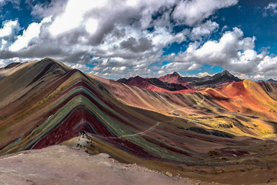
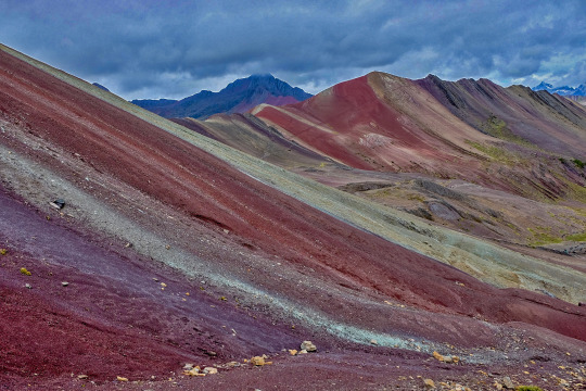
According to the research, the coloration of the rainbow mountain is due to the composition of minerals that it has: the pink color is for the red clay, fangolitas and arilitas. The whitish, for the quartzose ...
Showing posts with label ausangatemountain. Show all posts
Showing posts with label ausangatemountain. Show all posts
According to the research, the coloration of the rainbow mountain is due to the composition of minerals that it has: the pink color is for the red clay, fangolitas and arilitas. The whitish, for the quartzose sandstone and marls, rich in calcium carbonate. The red is composed of the clay (iron) and clays belonging to the upper tertiary. The green is due to the compound of phyllites and clays rich in ferro magnesian. The earthy brown is a product of fanglomerate composed of rock with magnesium belonging to the Quaternary era. And the mustard yellow color for the calcareous sandstones rich in sulfur minerals, the vinicunca mountain is rich in all these minerals. RAINBOW MOUNTAIN INFORMATION
Useful Information
- Starting Altitude - 3800m / 12,467ft.. - Highest Altitude - 5000m / 16.404ft. - Meals - 2 breakfast, 2 lunch, 1 dinner - Overall Difficulty - Moderate - STARTING POINT: - Cusco at your hotel
RAINBOW MOUNTAIN ITINERARY
DAY 1: CUSCO – OCONGATE – UPIS
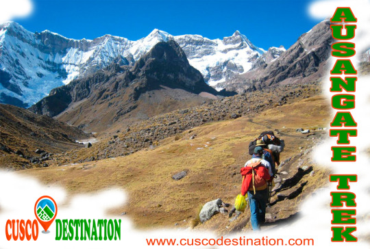
This first day we’ll leave Cusco very early for our three-hour trip in a private vehicle to the small village of Tinqui (3,800 meters). We will go by beautiful landscapes and several traditional villages as Urcos, Cattca and Ocangate. In Tinqui we will have lunch, after lunch we begin to walk through beautiful mountain landscapes with great views of Mount Ausangate. We walk for an average of 4 hours to reach the hot springs in Upis (4400 meters). In this place we will have dinner and spend the night.
DAY 2: UPIS – PUCA COCHA
After breakfast, we head to the first pass called the Abra Arapa (4850 meters). After passing the Abra we will have lunch, After lunch we continue on to Lake Pucacocha- a blue lake and a perfect stop for a break. Along the way you will see local herders and llamas, Ausangate mountain to your left, and you will have your expert guide explaining the history of the locals and talking about the landscape along the way. If you're lucky you may see condors and vicuñas at our campsite where you will be surrounded by high mountains and incredible glaciers- watch for the Ausangate glacier crashing into the lake below! As always camp will be set up for you to change and rest your weary legs and dinner will be prepared.
DAY 3: PUCA COCHA — ANANTA
After breakfast, We will start with a steep ascent of Puca Cocha pass. While is partially difficult, this pass boasts incredible views the entire way. The higher you get the more impressive the lake is below and Ausangate mountain sitting directly across from we. Take some time to enjoy these beautiful views. We will have plenty of time to take wonderful and impressive photographs. After conquering the pass we continue through a vivid green valley with llamas grazing everywhere. As you approach our destination for the day we will have camp set up for you to enjoy your surroundings and relax.
DAY 4: ANANTA — RAINBOW MOUNTAIN — Q´ESIUNO — CUSCO
We will wake you up extra early in the morning so you will can be the first people to the top of the Rainbow Mountain. After a hot breakfast, and some coca tea we will start with the first uphill climb- Ananta pass. Here you will see the beautiful Rainbow Mountain in the distance. From here you descend to a large valley and continue walking until we are presented with one final climb to the Vinicunca Mountain. We are going be the first ones at the Rainbow Mountain to enjoy the place at all with plenty of time for photographing, walk around and enjoy the beauty of the area. After we hike downhill for 2.5 hours to Qesoyuno where you have a delicious lunch surrounded by mountains. After lunch the car from the company will pick up us to drive back to cusco for 3.5 hours to take you back to your hotel.
WHAT TO BRING
A backpack
A beanie hat or ear warmer
Sun hat
Scarf
Gloves
A mid weight sweater
A longsleeve t-shirt
1 – 2 t-shirts
A lightweight suater or vest
A pair of long pants
Hiking shoes
An extra pair of shoe
2 – 3 pairs wool socks
A jacket
A small towel
Rain gear
1 – 2 pair shorts
Sunglasses
A small headlamp
Waterbottle
A toothbrust and other personal toiletries
Toilet paiper
Sun cream
Camera and film
Original passport (International Student Identity Card “ISIC” if applicable)
Extra money for drinks.
Emergency money at least 300-450 extra soles (USD$ 220)
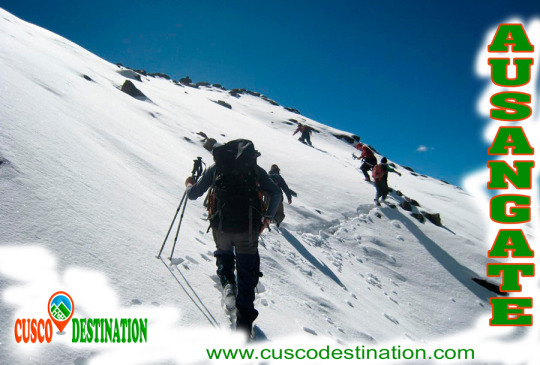
The Ausangate trek Circuit is definitely an adventure route recommended for those who like hiking, feel nature, the spirit of the mountains, and the energy of Mother Earth. The Ausangate circuit offers some of the most beautiful landscapes of Cusco, with varied wildlife, glaciers and Andean lagoons. Ausangate Trek is also one of the most difficult hikes in the region. The most important thing about this trip is that you’ll get to see the real PERU, the Andes and its people in their traditional dress, their customs that persist till today.
Useful Information
**- Starting Altitude **- 3350 meters / 10990 feet .
**- Highest Altitude **- 5200m / 17,056ft.
**- Meals **- 6 breakfast, 6 lunch, 6 dinner, 6 tea times, 6 wake up tea
**- Overall Difficulty **- Moderate - Changing
**- STARTING POINT: **- Cusco at your hotel IMPORTANT INFORMATION:
Ausangate is the fifth highest mountain in Peru; its maximum altitude is 6,372 meters.
The hike up the mountain of Ausangate is considered adventure tourism. The road presents rock formations at a height of over 5000 meters covered by ice tongues.
The waters of the snowmelt flowing westward give origin to the Vilcanota River, which subsequently flows into the Amazon River and ends up in the Atlantic Ocean.
Its eastern slopes feed several small rivers that culminate in the Inambari River and to the south it drains its waters into Titicaca Lake with the river Azángaro.
The temperature in the day is between 11 and 13 degrees Celsius and at night it drops to 4-10 degrees Celsius in June and July.
Brief Itinerary - DIA 1 : CUSCO - TINQUI – UPIS- DAY 2: UPIS - JATUN PUCACOCHA- DAY 3: JATUN PUCACOCHA - PAMPA CANCHA- DAY 4: PAMPACANCHA - LAGUNA TICLLACOCHA- DAY 5: LAGOON TICLLACOCHA - PACCHANTA- DAY 6: PACCHANTA - CUSCO
“2 brothers (Salkantay and Ausangate), which lived in Cusco decided during the great draught in Cusco to travel to other lands and find the remedy for their people. Salkantay went north to the jungles where he met the forbidden love of beautiful Veronica and lots of problems. The other brother – Ausangante went south. He found a fertile valley and could send potatoes, maize, lama meat and alpaca to Cusco and therefore saved the inhabitants of the city”. AUSANGATE TREK
This is the legend told by Quechua Indians about the Brothers-Mountains.
Ausangate is the highest peak of the second largest Peruvian glaciated system Cordiliera Vilcanota (120km long). Cordiliera Vilcanota is located approximately 100km south-east of Cusco. The magnificent Vilcanota River begins in these high glaciers and goes on to feed the Amazon River and Atlantic Ocean. Ausangante with its 6384 m / 20940 ft elevation above sea level is the fifth highest peak in Peru (and one of the highest peaks of South America) after Huascaran, Yerupaja, Coropuna and Huandoy.
In the mid 20th century several expeditions tried to climb Ausangate. The first mountaineer was Italian Piero Ghiglione who tried to conquer Ausangate in 1950. After the first unsuccessful try he returned in 1952 with multinational expedition. But this time the expedition also failed to reach the main peak of Ausangate. Finally, in 1953 the Autsrian-German expedition became the first to reach the top of Ausangate. The first Peruvian expedition to climb Ausangate was 30 years later!
Qoyllur Rit’I Festival
Ausangate – one of the main Apu (mountain spirits) is the deity of Cuzco. During the Incan Empire the Indians worshipped and celebrated this god. After the Spanish colonisation this festival became an amalgamation of the Indian worship of mountain spirits, and the celebration of the apparition of Christ on the mountainside. Qoyllur Rit’i is celebrated at the end of May – beginning of June and continues for several days. Qoyllur Rit’i in Quechua means “Snow Star”. This festival is held at Sinakara, at the foot of Mount Ausangate. The festival attracts more than 10 thousand pilgrims every year from surrounding villages and from all other parts of the country, even from the neighbouring countries. The arrangements start with raucous celebrations near the chapel. People in national costumes dance traditional dances. However, these are not the main events of Qoyllur Rit’i.
Groups of Queros indigenous people climb Ausangate Mountain, at 6362m, in search of the Snow Star which is reputedly buried within the mountain. The foreigners are not allowed to participate in this climb, according to the Indians, this may offend Apu Ausangate. For several days the pilgrims walk to the top of the mountain: through the dangerous paths and freezing passages, gasping for breath in the thin air, and overcoming numerous difficulties. The accidents are quite frequent – not everybody returns back (in this case, the Indians say that Apu Ausangate received its sacrifice). All of this is done for one purpose; to bring a block of ice to the Chapel. They people believe that the ice brings luck, has medical effects, and that the lands irrigated with this holy water will be very fertile.
Climbing Ausangate Ausangate trek is not for beginners! If you think that you are experienced enough for this ascent, spend enough time in Cusco before climbing the mountain, to allow yourself time to become acclimatised to the region.
How to get there
There are two routes from Cusco to Ausangate
Route 1: Take the intercity bus to Chillca village. From there you can walk to Campo Base - the starting point of the trek (it will take you 4 to 5 hours).
Route 2: Take a bus to Tinqui village then to Pacchanta. Then continue by foot through Acepo ravine (8 to 10 hours) to Base del Ausangate – the best starting point of the trek according to most mountaineers.
If you don’t have enough experience for independent hiking, you can visit Ausangate and marvellous surrounding areas in the company of experienced guides.
Ausangate Mountain is a natural attraction that is located in the district of Ocongate, within the province of Quispicanchi, in the department of Cusco. That snow is part of the Vilcanota mountain range and, according to an ancient legend, was the brother of Salkantay snow.
The Ausangate Snowy, has a height of 6,384 meters above sea level; and it is considered an apu, or protective deity of the surrounding peoples; as well as the most representative mountain in the region. Its size is such that it can be appreciated even if one is in the Fortress of Sacsayhuamán, not in vain is considered the fifth highest mountain in Peru.
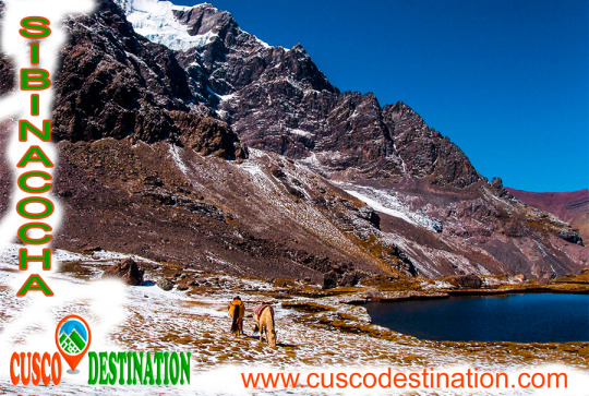
This beautiful snowy Cusco, impresses the eye, for its incredible natural formations; In that one there are not only beautiful mirrors of water such as Sivinicocha, turquoise waters, but also forests of stones, glaciers and high-plains that seem to make this natural attraction a paradise on earth, especially for those tourists who are interested for adventure sports since, the Ausangate landforms make it ideal for sports such as rock climbing, ice climbing, trekking, among other activities. Snowy Ausangate is presented before our eyes as a mountain challenge; it is known, that the first attempts to ascend it were made at the beginning of the fifties of the last century, were the first frustrated attempts to conquer the top of the powerful Apu, it was not until 1953, when a German expedition achieved the goal, climbing the mountain along its southern slope, in posterity, new routes were opened for the conquest of the Apu, however, only in 1983, thirty years after the first ascent, Peruvian feet crowned the top of the majestic snowfall.
The Cordillera Vilcanota with its 120km of steep peaks and glaciers is the second mountain range (both in extension and in glaciers) of Peru.
The Ausangate is located in the mountain range of the Andes, in a section called Cordillera de Vilcanota, corresponding to the Cusco region in Peru. Its main peak is 6,372 meters above sea level with green lagoons, bright turquoise.
The waters of their thaws that run to the west give rise to the Vilcanota River which later pours its waters into the Amazon River towards the Atlantic Ocean. Its eastern slope feeds several small rivers that culminate in the Inambari River and to the south drains its thaws to Lake Titicaca by the Azángaro River.