
It is located at the convergence of two valleys crossed by the Vilcanota, which the Incas called Willcamayu (Sacred River) and the Patacancha. At an altitude of 2,790 m.a.s.l.
One of the routes I do frequently, is towards the Inca quarries of Cachiccata. The last ascents I have initiated from the Inca bridge that is at the entrance of Ollantaytambo coming from Urubamba. This bridge consists of two eyes over the Vilcanota River (or Urubamba River). Its bases, of Inca origin, are made up of large blocks of stone and, to protect the central pillar, they placed two huge rocks as a water-breaker in the course of the river. In its origin, this bridge must have been a suspension, and like so many others that the Incas did, it was made with the braiding of a plant called “ichu”, which is still used today on the roof of many Andean houses.
INFORMATION OF INCA QUARRY TREK
Once across the bridge, the ascent begins on the left bank.
A sign shows us the route to follow, while we have a good view of the platforms that surround Ollantaytambo.
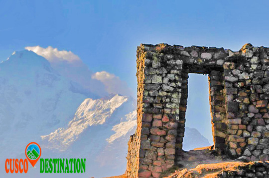
In front of the train station we will encounter a rocky ledge on which there are the ruins of a control or defensive fort known as Choquequillca.
On the other side of the Vilcanota River (right bank) we found no fortification, perhaps because it was destroyed with the layout of the railway.
Our goal is to visit the Cachiccata quarries and then continue the ascent to the top of the Arequipa Hill, where there is an Inca archaeological structure, known as INTI-PUNKU (Puerta del Sol).
The distance between the Inca bridge of Ollantaytambo and the INTI-PUNKU is about 8 km with 300 m. following a pedestrian trail. This journey can be done in one day without trying to break records. It is convenient to get up early to avoid the intense midday sun.
The initial road runs parallel to the Vilcanota River, with terraces on the left side. In front, on the other side of the river, we can contemplate another architectural group of the Inca culture; It is called Raqaypata.
A second part of the road, much wider, takes us to the bottom of the Cachiccata quarry (in Quechua it means “salt slope”). It is a continuous ascent to save the 400 m. of unevenness between the starting point (2800 m altitude on the Ollantaytambo bridge) and this lower quarry located at 3210 m.a.s.l.
Along this second journey, which is one of the ramps through which the Incas slid the pink stone blocks, we found some of these large stones that did not reach their destination and are known as “ Tired Stones. "
Here are two copies: the first one is located in front of the church of San Santiago Apostol (Ollantaytambo) and the second one is found on the way up to the quarry.
It is not uncommon to find tour groups accompanied by a guide, and pack animals transporting the materials of a long journey.
It is also common to find people picking aromatic or medicinal plants (muña, tara, ...)
It is obligatory for me, when visiting these places, to visit Don Guillermo Qawa; an old man who lives alone at 3022 m altitude and with whom I share a “little time” of company and some food, every time I make this route.
Why not mention the children Francisco, Roqui, Yéssica, Lourdes and Lisbeth to whom on this last walk we offered the promised toys?
The Cachiccata quarries are located under the impressive Black Good Apu from which the Incas extracted the huge blocks of pink rhyolite.
These stones were partially worked in the quarries and then down to the Vilcanota River in front of the Rumira sector.
Through an artificial channel parallel to the riverbed, they diverted the water alternately (in times of drought) and thus moved the blocks on either channel with an island in the middle. The blocks were dragged back to the fortress of Ollantaytambo.
The last section consisted of a steep ramp, which can be seen perfectly from the left bank of the river, as shown by the arrow in the photograph.
We know, from the tools that the Incas abandoned in the quarry, that they used the same stone for the extraction of the blocks: granite and basalt strikers, obtained in the Vilcanota River. These quarries had to be abandoned when Manco Inca retired from Ollantaytambo.
As for the transfer of the immense stones, we do not stop questioning the time, the way and the enormous amount of people contributing their strength and ingenuity. There is no doubt that the Inca people were construction experts; his numerous works that still endure so testify: Coricancha, Sacsayhuamán, Ollantaytambo, etc.
In the northern (lower) quarry of Cachiccata there are small constructions known as “CHULLPAS”. They are tiny towers of circular base, built with stones joined with mortar of red mud and straw. These are funerary constructions that abound in the Highlands of Peru and Bolivia, typical of the Qollas.
Those of Cachiccata, due to their small size, we deduce that they served as burial for a single person, in which they generally placed the deceased in fetal form along with some of their belongings. They have an opening or entrance in a rectangular shape and have the upper part or roof covered. Some are very damaged and others have completely disappeared; all have been looted by treasure hunters (Huaqueros).
At our feet is the small town that gives name to these quarries: CACHICCATA. A peasant community of about 80 families with approximately 320 people living on agriculture, especially corn and potatoes.
After replenishing forces, we continue the ascent to the west and south quarries. In both we find stones of greater size and better worked, as well as a limited enclosure in which the stones extracted from the quarry were stored and worked.
From this place we can contemplate a spectacular landscape:
· The wide valley crossed by the Vilcanota river with its diverse green tones, characteristic of the rainy months; and in the middle, the famous pyramid of Paccarectampu.
Regarding this truncated pyramid of Ollantaytambo, certain writings relate it to the founding beginnings of the Inca Empire. What we can confirm is that during the winter solstice (June 21), with the sunrise, it is possible to observe different light effects through solar projections on this pyramid of Ollantaytambo.
· Al Al frete, the imposing peaks of the Vilcanota Range, among which the Apu (divinity) or Veronica Snow also known as Wakaywilque with its 5,682 m.a.s.l. struggling to peek her white hair between the clouds that surround her.
I was surprised to find in these quarries a stone wheel (like an old mill) apparently unfinished, because the central hole was completely unperforated.
Continuing our ascent, the next stop was at the archaeological remains of Choquetacarpo located at 3,495 m.s.n.m, of which we do not know the purpose they had, although it seems to have been the residence of those who managed the quarry.
The trip continues in its last stage of ascent until reaching 3,943 m.a.s.l. With your eyes fixed on the INTI-PUNKU (Puerta del Sol) and the desire to complete the feat of reaching that altitude, forces arise under the intense sun and dizziness from the height. MACHU PICCHU TOUR
They are the last meters, some steps and we access the Puerta del Sol. An impressive spectacle appears before our eyes. Mute and contemplate is the most appropriate. Praise be my Lord!


0 comments:
Post a Comment