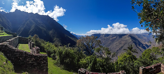
You can visit the architectural complex Choquequirao is situated in Vilcabamba at 3100 meters, considered the last Inka refuge and place of resistance from the invaders, when doing ....
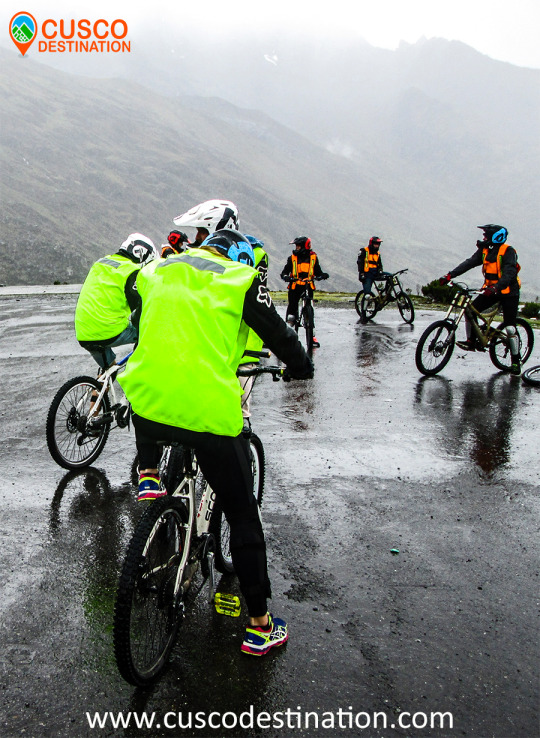
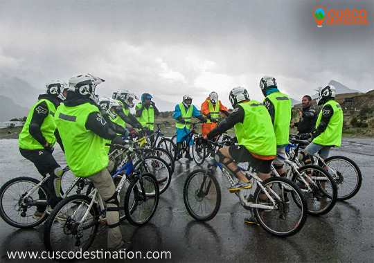
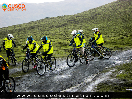
Our Inca Jungle Trail classic To Machu Picchu combines adventure sports such as mountain biking, rafting, zip line, hot spring and trekking for 4 days until you reach Machu Picchu....
In the upper area close to the Skies, the Incas built one of their best-preserved cities, now recognized as one of the 7 wonders of the modern world. Many travelers and adventurers come....
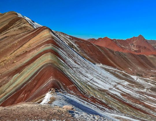
According to the research, the coloration of the rainbow mountain is due to the composition of minerals that it has: the pink color is for the red clay, fangolitas and arilitas. The whitish, for the quartzose ...
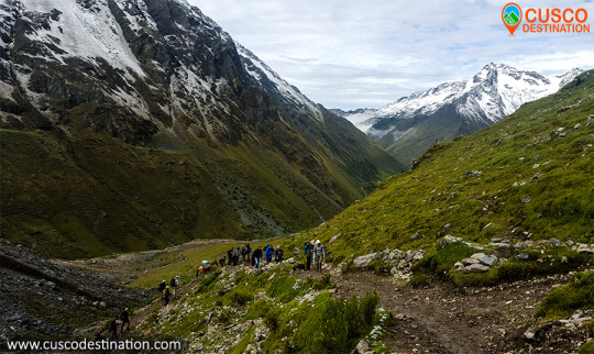
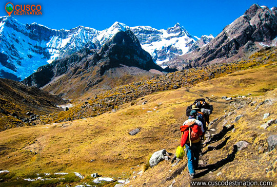
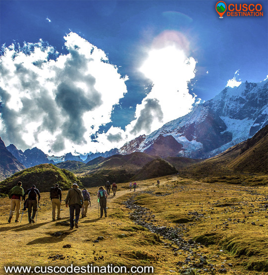
MORE TOURS IN CUSCO TO MACHU PICCHUOne of the most incredible ways to visit Machu Picchu is through the Salkantay trek. This 5-day and 4-night hiking route crosses the imposing snow-capped Salkantay and then reaches the Wonder of the World. Would you like to know Machu Picchu with this adventure surrounded by amazing landscapes? Know everything you need to know about the Salkantay trek.
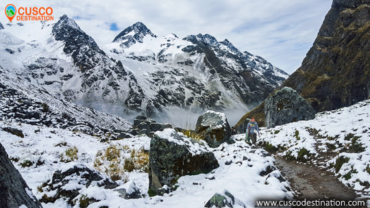
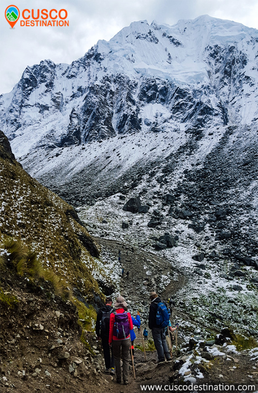
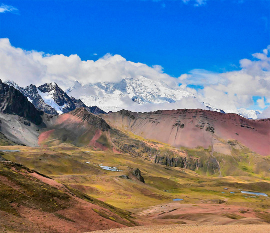
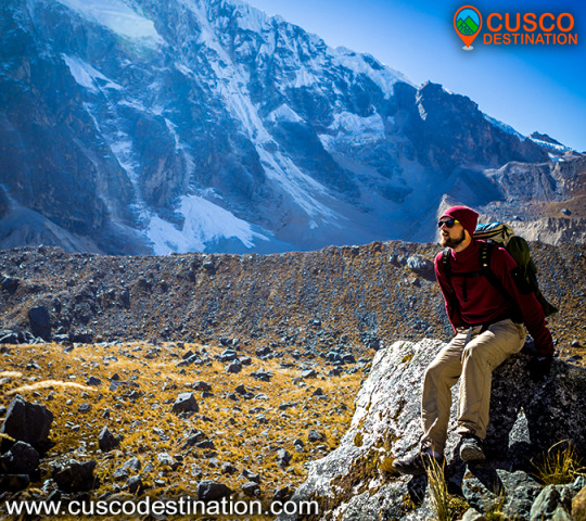
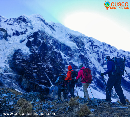
What does Salkantay mean? The Salkantay is a snowy mountain whose name translated from Quechua would mean ‘Wild Mountain’. This summit is known as ‘Apu’ (‘Lord’) for its majesty and elevation. Where is it located? The pu Apu ’Salkantay is located in the Vilcanota Mountain Range in the Andes of southern Peru. This snow-capped mountain is the second largest in Cusco, after Ausangate (Mountain of the 7 Colors). How high is the snowy Salkantay? The snowy Salkantay reaches 6,271 meters above sea level (m.s.n.m.). The trek route that leads to Machu Picchu has its highest point in the ‘Abra Salcantay’, at 4,650 m.a.s.l. From there you can see the peak of the snowy peak. How's the weather? The snowy in itself presents an extremely cold climate (several degrees Celsius below 0º).
The climate during the Salkantay trek, on the other hand, is varied. The intense sun and the nightly cold in the early days are changed by the tropical environment in the latter. What is the flora and fauna like? The 5 days and 4 nights of the Salkantay trek cover landscapes with a great variety of flora and fauna. Among the species of flowers and plants, the orchid and the ichu (Andean grass) stand out. Among the species of birds and animals, it is worth mentioning the llama, alpaca, vizcacha, condor, spectacled bear and the cock of the rock (national bird of Peru)
Salkantay trek: everything you need to know
What is the Salkantay trek? The Salkantay trek is a hiking route that takes the visitor to the Inca City of Machu Picchu. The total walking distance is approximately 70 kilometers (5 days of route).
The Salkantay trek is considered among the 25 best excursions in the world by National Geographic Adventure Travel Magazine.
Classic Salkantay trek 5 days is considered by most to be the best alternative route, This walk allows you to enjoy the options that there is in the salkantay route, you will go up to humantay lake, you will pass for the highets point of the salkantay route to be to see salkantay mountain up close, you hike through the santa teresa valley that is full of vegetation is the begining of the peruvian amazon, you have the chance to see, plantations of coffe, coca, avocados, bananas and much more, this valley is full of fresh wáter with many waterfalls and also if your choisce this hike, you will have enouth time do the relaxing hot springs of colcalmayo in santa teresa. and also you can do Llactapata hike on 4th day of the our advedventure, if you are an adventures person you got the chance to do the biggest and longest zipline of southamerica. choose this one and get a perfect adventures vacation to Machu Picchu.
Useful Information
- Starting Altitude - 3350 meters / 10990 feet . - Highest Altitude - 4600 meters / 15091 ft - Walking Distance - 12km / 7.45 miles - Campsite Elevation - 3920 meters / 12861 ft - Meals - 4 breakfast, 4 lunch, 4 dinner, 3 tea times, 3 wake up tea - Overall Difficulty - Moderate - Changing - STARTING POINT: - Cusco at your hotel
IMPORTANT INFORMATION:
The snow-capped Salkantay is one of the highest mountains in Cusco, along with the Ausangate mountain in the Vilcanota mountain range which is located further south. The Salkantay Trek to Machu Picchu is listed as one of the 25 best treks in the world by National Geographic Adventure Travel Magazine. The Salkantay Trek is definitely one of the very best trekking adventures that you will find in Cusco and in Peru. After the Inca Trail classic or Inca Trail short, the Salkantay route is the 2nd most popular to Machu Picchu (and a lot less crowded). Machu Picchu is one of the 7 Wonders of the Modern World, Heritage of Humanity, Historical Sanctuary of Peru and probably the most important archaeological site in Latin America. Machu Picchu is majestic architecture comprises 140 structures throughout the citadel. Machu Picchu is was built by the Inca Pachacutec around the year 1460 After being forgotten, it was only in 1911 that the American Hiram Bingham reached Machu Picchu on an expedition and spread the site worldwide.
Brief Itinerary - DAY 1: Cusco – Mollepata – Humantay Lake – Soraypampa - DAY 2: Soraypampa – Salkantay Pass- Huayracmachay - Chaullay - DAY 3: Chaullay - La Playa - Santa Teresa (2nd option camp in Lucmabamba) - DAY 4: Santa Teresa – Hidroelectrica – Aguas Calientes (Llactapata - Aguas Calientes) - DAY 5: MACHU PICCHU - CUSCO
MORE TOURS IN CUSCO TO MACHU PICCHU
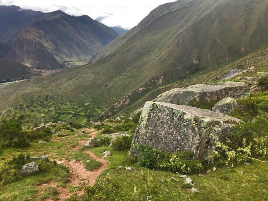
The Incas covered much of the South American continent. To maintain communication in such a vast territory, it was necessary to build a network of roads. Thus, the Inca ordered to build a network of roads called Qhapac Ñan (Inca Trail).
The Qhapac Ñan managed to cover up to 30 thousand kilometers from the current countries of Peru, Ecuador and part of Bolivia, Chile, Argentina and Colombia. The trekking route from the Inca Trail to Machu Picchu is only a small part of the extensive network of roads of the Qhapac Ñan.
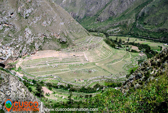
The Inca Trail was revealed to the world in 1915 when it was being excavated in the Inca City. Three decades later, the route was traced by the Viking expedition in 1942. Today, thousands of visitors decide to travel the 43 kilometers to the ‘Puerta del Sol’ in Machu Picchu.
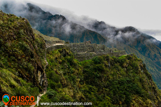
However, Machu Picchu is not the only archaeological site that you will see on the Inca Trail. On the tour you will also appreciate the ruins of Llactapata, the archaeological site of Runkurakay, Saycamarca, Phuyupatamarca and Wiñaywayna.
There are trains and buses that can take you directly to Machu Picchu. However, the experience of arriving as the Incas did for centuries is unmatched.
Versions of the Inca Trail to Machu Picchu
Not all people have the days necessary to travel the Inca Trail (4 days and 3 nights). That is why there are 3 versions depending on the time you have:
Classic Inca Trail: 4 days and 3 nights (43 kilometers of walking).
Imperial Inca Trail: 5 days and 4 nights (43 kilometers of walking).
Short Inca Trail: 2 days and 1 night (12 kilometer walk).
About tickets to enter the Inca Trail
Due to the high demand for tickets, you must get the entrance tickets to the Inca Trail well in advance (6 months). The purchase is made only online through the website of an authorized tourism agency.
In total 500 people enter the trails of the Inca Trail every day. Of these, only 200 are tourists. The rest are support staff such as cooks, porters, guides. The ticket to enter the Inca Trail includes support staff.
Did not find availability to do the Inca Trail?
The only way to enter the Wonder of the World is by train through the Sacred Valley of the Incas or by the alternative route from Santa María to Machu Picchu. Entrance tickets to Machu Picchu must also be reserved in advance.
Do you want to enter the Huayna Picchu after the Inca Trail? Request entry into the agency paying an extra price. You can also request a more luxurious train service.
INFORMATION OF INCA TRAIL TO MACHU PICCHU
While in Ollantaytambo the first objective is to reach the Cachicata quarry located six km from Ollantaytambo and at an altitude of approximately 4,100 m. There, not only did the Incas extract the enormous stones, but they also partially carved them to be later lowered to the Vilcanota valley and from there, climbed them up a steep slope to the Ollantaytambo fortress. CACHICATA TREK INFORMATION
We know from the tools that the Incas abandoned in the quarry that they used the same stone for extraction: granite and basalt hammers, obtained in the Vilcanota river. As for the transfer of the immense rocks, we do not stop questioning the time, the way and the enormous amount of people contributing their strength and ingenuity. There is no doubt that the Inca people were a construction expert. His numerous works that still endure in the Sacred Valley bear witness to this: the Coricancha, Sacsayhuamán, Ollantaytambo, Machupicchu, etc. Next to the quarry there are small constructions known as "CHULLPAS". The ones that we could see here are small towers with a circular base, built with stones joined with mortar of red clay and straw. These are funeral constructions that abound in the Altiplano of Peru and Bolivia. Those of Cachicata, due to their small size, served as a grave for a person, in which they generally placed the deceased in a fetal form along with some belongings. As we can see the illustrations present, they have a rectangular opening or entrance. And covered at the top.
From this place, the view is recreated with the scenic picture in front of it. At our feet the wide plain crossed by the Vilcanota river, with its various green tones characteristic of these rainy months; to the front, the imposing peaks of the Andes, among which Veronica stands out fighting against the clouds to show her white hair. Our descent into the valley is made by the same ramp that the Incas used to slide the pink stone blocks. Along this journey, you can see how some of these stones did not reach their destination; they are known by the name of “Piedras Cansadas”. Already entered in the municipality of Ollantaytambo, we had two important archaeological-logical centers to visit: the city and its Inca fortress.
MORE INFORMATION OF INCA QUARRY TREK
Many people ask the question of why the Colors of the Rainbow Mountain, in this article we will answer all your questions and you will find some other things. The Vinincunca mountain of colors has come to fame very quickly, becoming one of the most visited tourist places in Peru by tourists from all over the world, for the great attraction of its colors and its beautiful landscape view of its snow-capped mountains that has captivated More than one visitor, if we look up at the horizon we will be able to see the rocky mountains, the red valley, that if they could speak for sure they would tell us a lot of stories from past times and tourists who visit it day by day. RAINBOW MOUNTAIN INFORMATION:
The concern to know the reason for its colors leads us to ask ourselves many questions and to obtain the answers we go back to approximately 24 million years ago. Rainbow Mountain Formation Processes
The formation of the 7-color mountain according to studies dates from the Campanian era, which is part of the geological era belonging to the Cretaceous; where the continents were already separated and many of them covered with seas, so the seven-colored mountain was also covered with shallow sea. Geological era of the Cretaceous and Paleocene
After many millions of years the Cretaceous geological era goes down in history with the extinction of the dinosaurs, as a result of the fall of a meteorite, so the climatic conditions begin to change and some seas dry up, that is where the geological era of the paleócene many mountains covered with sea are discovered and among them the mountain of seven colors appears, the mountains that appeared in the light were massive rocks that with the climatic conditions of many millions of years these have been eroding and becoming different colors according to its composition elements.
If we visit the Vinincuca mountain and approach the safety rope that protects the mountain, we will be able to observe that it is not really fine colored sand as we might think, but rather it is particles of rocks in the process of erosion.
If we do not have the opportunity to get closer to the mountain, we can be very observant along the way, we will surely find some eroded colored rocks, there we can better observe and feel them.
Among its colors we can find the following composition:
Pink color: Composition of red clay, mud and sand.
Off-white color: White quartz sandstones
Brown, brown and purple color: Composed of limonites and marls, rich in calcium carbonate.
Red color: Composed of clays and clays rich in iron
Green color: Composed of phyllites and clays rich in magnesium iron.
Brown color: They are earthy is a product of rock fanglomerate with magnesium.
Mustard yellow color: Composed of calcareous sandstones rich in sulfur minerals.
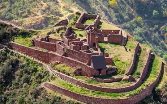
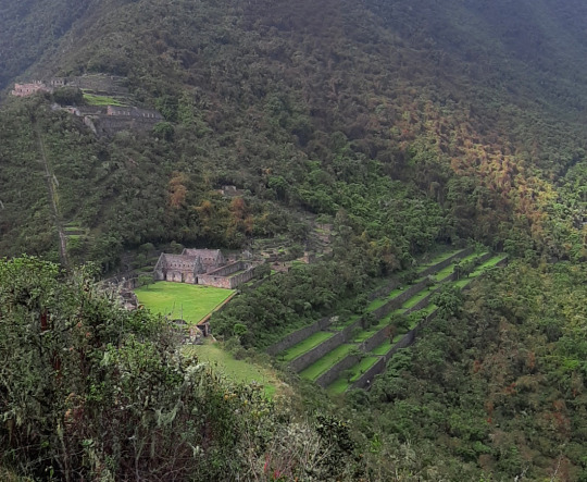
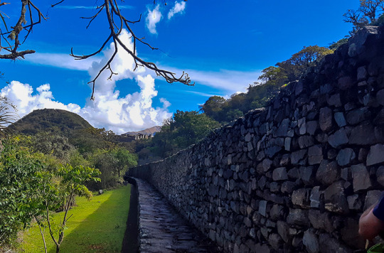
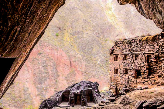
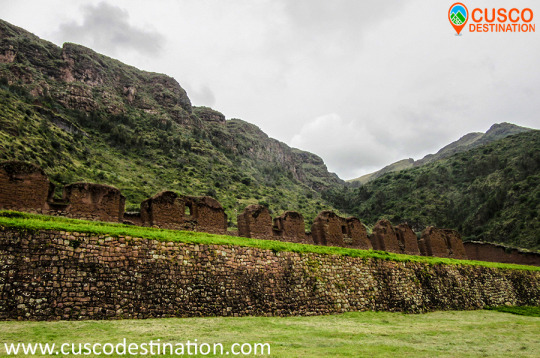
Sectors of Choquequirao
In sector I, the sector of the plaza and temple, hanan area, located to the north and which is the highest part, there are five floor buildings, located on terraces of different levels. It is possible that they served as the residence of the priests. Higher up, there is another smaller plaza where two warehouse buildings (qolqas) and three other long residential buildings are located.
(kallankas). A wall with a main channel of water collected from the Ch’unchumayo stream also enters here, supplying the archaeological site and descending, like a spinal column, organizing the arrangement of the buildings.
In sector II, hanan zone, there are the deposits or qolqampatas divided into warehouses with internal subdivisions with quincha partitions; in another space, within this subsector, there are small ceremonial platforms (16 platforms), crossed by an alternate channel that takes advantage of the waters of the main channel. CHOQUEQUIRAO TREK INFORMATION.
Sector III, which appears to be the main square or Hauqaypata, is located between the upper (hanan) and lower (hurin) sectors, on the filling of a platform. On the extreme sides of this square there are buildings with one and two levels. In the north there is a kallanka (building) for ceremonial use — Sunturwasi — with low niches (kind of chapels); To the east are two-story buildings with walls that support gabled roofs. They have two facades, one for entering the main plaza and the other that leads to a patio with side accesses. Access to these buildings is through double jamb covers (a double frame). These buildings are separated by a corridor, which highlights the largest building (kallanka) in the city that goes to the side of the backyard and that leaves through a wall to the south side, which is where the platforms in the north sector are located. of the city or llacta.
Sector IV, located in the Hurin or south zone, is a main construction made up of five covers called by Sartiges "triumphal wall" and by Samanez and Zapata "wall of offerings to the ancestors". The other four, probably, were for ceremonial use and would correspond to an open temple. Behind these covers is a field, where you enter a second level, which is above the covers.
Sector V is the ushnu: a hill cut at its top that forms a ceremonial oval platform and surrounded by a small wall as a fence, which is entered by an entrance that first rises by steps and from where you can see the main square and hanan site. From this place the snow-capped mountains and the Apurímac river are visible.
Sector VI is the Wasi Cancha, located south of the ushnu in the lower part; It is also known as a temple and home of priests. A space of four platforms with zigzag walls is observed, which was used as a ceremonial space. In the first wall it is finished off with a source for water, and the other platforms are accessed with stairs. Below this area of worship you can see a field or space with two enclosures of one and a half floors enclosed by a perimeter wall; from here you can see a good part of the Apurímac river canyon.
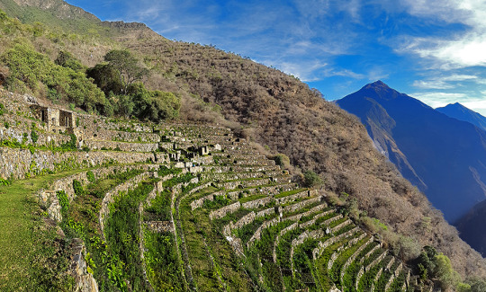
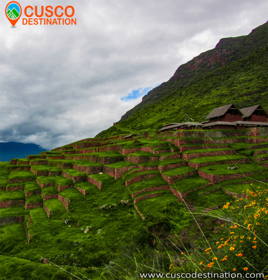
Sector VII belongs to the cultivation platforms on the east side. It stands out from the rest, for being wide and wide platforms. It can be entered through walkways from the main square.
The discovery was made in September 2004 within the framework of the «Cadastre and Delimitation (...) Sector VIII is an area of cultivation platforms, located on the west side, with eighty platforms, divided into plots and water channels that descend from the main square. Here were the famous "Llamas del Sol"
The ceramic remains show a multi-ethnic presence of the llacta (even though there has been int (...) Sector IX is made up of popular houses, also called Pikiwasi, and is where one of the water channels ends. The houses seem to have been for collective and family use, built on artificial platforms, rectangular, square and circular in design, communicating by means of stairs and narrow passageways.
Sector X is made up of the cultivation platforms, the Paraqtepata, made up of 18 platforms and irrigation channels parallel to the stairs. Sector XI also has cultivation platforms, the Phaqchayoq, made up of 80 wide platforms, the largest of the entire complex and located on the right bank of the Ch’unchumayo stream. There are also small quadrilateral enclosures in the middle of the plots with two-level enclosures, both for ceremonial use and for housing, with three sources for water and irrigation channels. Sector XII presents cultivation platforms three hours away from Hanan Square, and is made up of 57 platforms with permanent irrigation. In the upper part there are buildings for ceremonial use that occupy the entire width of the platform, a spring pool, a semicircular enclosure where ceramic remains, stone tools and bone remains were found.
MORE INFORMATION OF CHOQUEQUIRAO TREK
It is an Inca urban construction, which archaeological studies may be better specifying in the future, as its architectural structure and functions are analyzed. Only archaeologists will determine if there is material evidence with greater antiquity in the same location.56 In a general sense, the Andean populated centers especially Inca also called liadas, are characterized by being fixed according to a distribution pattern: square; a number of large, elongated and rectangular buildings called kallankas; deposits or collqas; platforms or ushnu cradle in their squares for the cult of the Sun and probably to carry the agricultural calendar with more precision (Thompson 1972: 78; cf. also Ayme Carrasco 2003: 237-38, 250-53). According to ethnohistorians, these populated centers followed the model of the city of Cusco, where the ritual and ceremonial spaces had the solar temple, royal apartments and, what we could call, a civil administrative part: prisons, acllahuasis, warehouses (Espinoza 1997b : 362; cf. also Rostworowski 2004: 173). However, it cannot be asserted that there was a general and constant pattern for all urban settlements, Choquequirao is also a good example of the adaptation in a steep and high terrain of a llacta that conserves the fundamental elements, but adequate to a certain area of construction. INFORMATION OF CHOQUEQUIRAO TREK
The urban layout, as seen by archaeologists, follows the dual Andean pattern. There is a high sector: hanan, and another low part, hurin. In this regard, archaeologists Roberto Samanez and Julinho Zapata point out:
When studying the distribution of functions in Choquequirao, a dual organization is perceived, very widespread, which creates a high sector and another low part or Hurin. It has been established that the High Sector is the one occupied by the buildings in the extreme North, and the Low sector is the one next to the main square where ceremonial buildings are located, the three two-level buildings and the two Kallankas. (Samanez and Zapata 1999: 90)
Choquequirao is built following a north-south axis with a drop of 65 meters in height between the first and second planes. Each plan has three groups of constructions that are distributed following the topographic disposition of the terrain. The central area of the complex, probably ceremonial, is 700 meters long.
MORE INFORMATION OF CHOQUEQUIRAO TREK
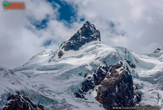
The snow of Ausangate is the fifth highest in Peru and the most representative of the Andes. It is located in the Vilcanota mountain range, it is one of the most difficult areas to access.
The highest peak of this snowfall passes 6,000 meters above sea level, in this place there are large lagoons with blue and green colors, there are also rocks that cause the area to be like a paradise and very modern. This is a very attractive place for people who practice adventure sports, thanks to its geographical accidents it is possible to practice climbing and trekking.
The snowy Ausangate is the representative mountain of Cusco and the Peruvian Andes. It is located in the Vilcanota mountain range and is one of the most difficult areas to visit which makes it a fabulous route to venture. Its main climate is 6,372 meters above sea level, with large green / blue lagoons. In addition there are rocks that make the area like a paradise. Performing the Ausangate trek is an indescribable adventure, and it is impossible not to be impressed by the enormous beauty of eternal snow. Often you will find mountains of a height of more than 5000 meters and also rocks covered with tongues of ice, spreading in magnificent forms forming ice lagoons. The Ausangate walk is one of the tourist destinations in Cusco.
In the Inca mythology of this mountain and the nearby lakes - among which Sibinacocha stands out - the masculine energy that fertilizes Mother Earth Pachamama is born, after a long course, the waters are lost in the unknown lands of the Amazon to return, to fill the lakes and glaciers every night turned into the river of stars or Willkamayu known in the West as the Milky Way The Community of Chillca constituted by shepherds of llamas and alpacas is known as the guardian of these pristine places, from where you can do mountain walks spending the night in comfortable hostels or tambos, among which Machuracay Tambo stand out, in a walk called "Path of the Apu Ausangate".
Every year on the north side of the Ausangate, the festival of Quyllur Rit'i (Quechua: "star snow") is celebrated before the feast of Corpus Christi, during which thousands of inhabitants make pilgrimages to the Lord of Quyllur Rit'i in the church from Sinakara. The Ausangate snowy usually takes 7 days tours, it is an adventure that no one should miss.
AUSANGATE TREK INFORMATION
The first attempt to ascend the snow of Ausangate, was at the beginning of the 50's, being the first 2 attempts frustrated. It had to wait until 1953, for a German expedition to reach the top of the Apu, ascending on the south side. Later, new routes were implemented to climb to the top of the mountain. Only in 1983, Peruvian feet reached the top of the snow.
Location
It is located in the district of Ocongate, in the province of Quispicanchi, belonging to the department of Cusco in the Vilcanota mountain range.
Climate and temperature
The predominant climate of the area is cold, at night it reaches temperatures below 5 ° C, by day it can be up to 20 ° C, it also has cold winds during parts of the day. In the area there are also rains and snowfall.
Altitude
The maximum peak of the Ausangate snowfall is 6,372 meters above sea level.
How to get to Ausangate Snowy
There are 2 routes to get to the mountain, the first is to go by bus from Cusco to the town of Chilca, from here you can take a walk from 4 to 5 hours to the Base Camp.The other route is a bit longer but cheaper, this is to go from Cusco to the town of Tinki by bus and then take a bus to Pacchanta. From this point along the steel gorge, it is 8 to 10 hours to the Ausangate Base.
Between the snow-capped mountains of Ausangate and Sinakara, is the Coyllur Riti Shrine, popularly known by the inhabitants of the area as Taytacha Coyllur rit’i, whose meaning is Lord of the Shining Snow. Every year here in the months of May or June, the Coyllur Riti festival has been celebrated since ancient times. Celebration during which thousands of Quechua pilgrim to the Lord of Coyllur Riti. This ritual is associated with the fertility of the land and with the worship of the Apus (hills, gods, guardians), one of the largest indigenous nations of America is celebrated.
The Salkantay Route, also known as the “New Inca Trail”, is located north of the city of Cusco, following the Cusco - Limatambo - Abancay - Lima road, making a detour between Limatambo and Mollepata.
Salkantay snowy climate:
It is very sunny during the day, but cold at night. The temperature drops below 0 ° C at night during the months of June to September. In the season from December to March it is very rainy so it is not recommended to go on these dates.
The best time to do this trek is during the months of March to September.
This hike reaches a height of 4,600 meters above sea level at its highest point is on the slopes of the same snowy Salkantay. Enter Ausangate 5D Snowy Walk to do this little walk.
How to get to the snowy mountain of Salkantay
The buses from Cusco to Mollepata leave very early from 4 am to 5 am and pass through Limatambo, from Mollepata is where the trek to the snowy Salkantay begins, after climbing a step it is possible to have an impressive pyramidal view of Salkantay, one of the mountains most beautiful snowfall of Cusco.
From Mollepata it takes two days to descend to Huayllabamba and join the second day of the Inca Trail.
What you will see along the way
On the way you can see herds of cattle and sheep, orchids, bear with glasses, medicinal plants of the Inca eponca, small variety of birds, fruit trees such as orange, papaya, bananas, and so on. Note: The eye of the glasses to see it is necessary to have some luck.
recommendations
It is very important for the traveler. Bring your original passport for the respective controls.
RECOMMENDED MONTHS TO TRAVEL
March: (a little rain) From April to October: (an excellent trip) From October to November: (a little rain) December to February: (lots of rain) SALKANTAY TREK INFORMATION
Note: There is, in my opinion, a controversy regarding the paternity of the first ascent of this crest S.E., since it consists in the previous realization of a powerful group of Japanese who achieved the ascent by this route. Unfortunately, the only reference found in this Japanese ascension dates from an Iwa magazine to Yuki, written, of course, in Japanese, so without a translation of the text there is no concrete data.
Humantay Mountain - Salkantay Route To Machu Picchu
The western edge of the Salkantay is a route that remains virgin after years given the complexity of its layout and the distance from the traditional approach points, which requires additional porting based on the dragging of backpacks.
According to the prestigious Pyrenean Louis Audoubert, who ascended to the top by the northern slope in 1977, the west edge is feasible, but it will certainly be a good problem to solve at the Andean level.
This crest was attempted in 1975 by a group of Catalan climbers from Mataró formed by Manuel Punsola and Mitjans, Miquel Sala and Roy, Xavier Varela and Pinart, Ramón Armengol and Carbó, Antoni Sors and Farre, Antoni Rosa and Olivera and Vicente Aris and Julta .
On August 5, 1975, three members of this expedition approached the edge by an additional buttress of the northern slope that had been previously recognized. They go up for a good part of the day until they reach a point with two possibilities that seem unattainable. The logic was to tackle the ice ridge, something impossible given the lack of material means. The other option would be to flank the slopes of the ridge to look for the hill between the two Salkantay peaks.
At a certain point of this great flanking, which they calculate, it will take them a whole day, they decide to leave due to the large number of avalanches that leave the ridge and that are obviously a first order objective danger. Catalan climbers believe that the difficulties so far have not been important or dangerous, but moving away from the obvious route of the ridge, which would require more human and material equipment, greatly increases the risk.
Coming from Mollepata the first vision we will have of Salkantay is in its overwhelming south face a huge wall that closes the bottom of the valley with its vertical seracs hanging from huge rocky spurs, this wall could not fail to attract the attention of those who try to complicate a little their lives for pure personal satisfaction, so in 1970 a powerful group of Germans from the Munich DAV composed of Walter Welsh, J.Vogt, H.Koebrich, H.Haver and M.Olzowy made a meritorious attempt on the left side of the wall, leaving quite high on the crest that descends to the western summit of Salkantay.
In 1986 an English group led by J.Lowe broke through this hillside attacking the rocky base to the right of the German attempt of the 1970s. The snow zone continued a slight diagonal to the right until it reached the eastern peak of the mountain.
On June 15, 1978, a powerful Slovenian expedition of the Planinska Zveza, composed of Libor Anderle, Zoran Breslin, Marjan Brisar, Edi Torkar, Jure Zvan and Jure Ulcar, accompanied by Dr. Borut Pirc and Matjaz Derzaj as coordinator, opened in a week Exploring and climbing an intelligent route along the eastern slope of the mountain, the Slovenian route, which without detracting from the difficulty, is the most feasible option of trying to reach the top.
The second ascent to this route was made by the Mexican Roberto Morales Puebla and companion on June 17, 1978 and the third by Los Vascos de San Sebastián, Iñígo and Jesús Mª Barandiarán, José Luís Conde and Jesús Mª Rodríguez accompanied by Alberto Cabezón and José Antonio Fernández de Aranguiz on July 3 of the same year, which makes it the first ascent of mountaineers in the Spanish State.
The Salkantay has been visited by mountaineers from around the world, French, Swiss, North American, New Zealander, Polish, Austrian, German, Mexican, Slovenian, Slovenian, Spanish (Asturian, Basque, Andalusian, Catalan)…. that have crossed its steep slopes… some lived the light of the reward from the top ... others, a great majority, had to withdraw when the chance of triumph among the cornices escaped. SALKANTAY TREK TO MACHU PICCHU INFORMATION
Also known as Salkantay, Peru's snowy peak located in the department of Cuzco, it is one of the main elevations of the Vilcabamba Range, an extension of the Eastern Cordillera, a mountainous branch of the Peruvian Andes. It reaches an altitude of 6,271 meters. It has two snowy peaks, known as China Salkantay and female Salkantay, separated by a port that opens to the Santa Ana Valley in the province of Urubamba. Both the mountain pass and the course of the river that is born there are called Salkantay. This river pours its waters into the Urubamba on its left bank.
Our company has the Salkantay Trek, a walk that will take you to Machu Picchu.
Hence the name of Snowy Salkantay:
The name of this mountain is a contraction that comes from Salga = sullen or wild and Antay produces bees or avalanches. It is usually preceded by the name of Apu, which in Quechua language comes to mean sir, is defined as large mountains that mean something sacred above the valleys. For example, Apu Salkantay in the Vilcabamba mountain range.
Snowy Salkantay (6,271) Source: Musical Henares, S.L. (Alcalá de Henares - Madrid)
The great white Apu. A little stories between ropes and crampons:
The Salkantay is one of the highest mountainous regions of the Qosco (Cusco). The highest mountain is the Gran Agusánate with 65 meters more in the Vilcanota mountain range located further south. However, and without a doubt, it is the greatest in its splendid isolation and in the greatness of its double-headed massif, to which is added the fact of being one of the mountains of this magnificent Andean region that presents greater technical problems for all its slopes This is evidenced by the six itineraries opened to date by the different slopes of this white giant.
His conquest dates from 1952 by the Swiss cordate composed of Bronimann and Marx.
This first ascent, like so many others in the history of mountaineering, is involved in several contradictions, since a few days later it is promoted again by a Franco-American expedition that included the well-known and relevant mountaineer of the Claude Kogan era.
Modern statistics merit being the first woman on top of the Italian Consuelo Bonaldi who climbed Cresta Este on August 4, 1978 accompanied by G.Marconi, A.Monononi, F.Nodari, S.Castellani, Augusto Zanotti and M.Quatrinni, obviously this is a mistake, since Claude Kogan did it 26 years before.
The Salkantay summit has two peaks, the East and the West, formerly the West, more slender and attractive than the East, which was slightly taller because it was crowned by a seracoa. After the passing of the years and the collapse of this serac, as the prestigious Pyrenean Louis Audoubert has pointed out, the height is practically identical in both peaks.
What happened in those two consecutive “first ascents” gave rise to the controversy that it had really been the first real one. The Swiss went up in the fog to the top of the East (the lowest in those days), the Americans however went up to the West, which was somewhat higher so the statistics, always relentless, want to deny Bronimman and Marx his first absolute ascension.
In 1953 he was climbed for the third time by the prestigious Alpine guide Lionel Terray, who together with the Dutch T. de Booy and the Swiss Raymond Jenny defeated the summit following a route along the northern ram, now known as the Terray Ram.
Years later, a German expedition tries the top following the dangerous crest of the N.E. which, with its cornices, does not favor traffic ... a relevant rope formed by Tony Mazenauer and Fritz Kasparrek (the latter conqueror of the north face of the Eiger) disappears on this ridge and the expedition has to be withdrawn.
Today there is a plaque commemorating that unfortunate event under the passage of Palcay (the usual base camp of the mountain) and on a block of visible rock.
On August 23, 1975, it was the turn of a long and steep crest of the S.E. of an Australian-New Zealand expedition composed of Peter Jennings, Wayne Barton and Michael Andrews. This ascent was the ninth to the top.
This place was dedicated to the extraction and carving of the stones that were used for the construction of Ollantaytambo and many surrounding precincts. This place is located about 14 km from the Inca town of Ollantaytambo and has three groups of quarries: Molle Pucro, Sirkusirkuyoc (it was the largest of the three), shows the evidence of having been fully operational when the Spanish arrived in this area . And finally Cacchicata or Kantirayoq, where another type of extraction of minerals and precious stones was practiced. Visitors can observe the great work done at the time of moving the giant stones to build Ollantaytambo enclosures. We can find the stones called "Tired Stones" that were on their way to Ollantaytambo and in some parts of the city.
Cachicata or Inca quarry is one of the old quarries used by the pre Inca and Inca civilizations to build the vast complexes of Ollantaytambo. It was a source of large amounts of pink granite. Cachicata quarries are 14 km from Ollantaytambo. The view of Ollantaytambo from the quarries is spectacular and during the walk you can see many large stones that remained in the middle of their long trip to the village. It was also a commercial route for the Incas. Cachicata is a small and remote town that can benefit from the occasional visit of tourists.
The Hike to Cachicata is a great alternative to the famous Inca Trail hike. This road was built by the Incas and used for hundreds of years to access local communities and transport goods. This trail is not as well known as the Classic Inca Trail, so much less crowds and a more serene trekking experience in Peru are expected. This hiking adventure not only visits Peru's cultural past, but also explores modern Inca communities and customs. The trail takes us through isolated waterfalls, ancient terraces and exotic wildlife, while offering fantastic views of the Sacred Valley and its snowy mountains. Visit with local families and explore an active quarry. Each step brings a new look to the Inca culture.
How long is Ollantaytambo?
The trip from the city of Cusco to the Inca city of Ollantaytambo is approximately 1 hour and 30 minutes in private mobility but if you wish to travel in the public transport units the approximate time is 2 hours.
Can you climb to the Inca quarry of Cachicata without a guide?
The Walk to the Inca quarry of Cachicata being part of the Inca road circuit that runs through the country of Peru, and the circuit of Qhapap Ñan, it is recommended that it be carried out with the supervision of an authorized agency that provides the professional guide service so that you can enjoy the best way to hike and take a nice memory to your country.
How high is Inti Punku "Puerta del Sol"?
Inti Punku or «Puerta de Sol» is the highest point on the hike to the Inca quarry being at a height of approximately 3886 meters from that point you can see an impressive view of the Sacred Valley and the Snowfall that are around as are the snow Veronica.
What should I take to make the walk to the Inca quarry of Cachicata?
To make the walk without any inconvenience we recommend the following:
A lightweight backpack to carry your stuff.
Water bottle.
Money for snacks, souvenirs and tips if you want to tip.
Hat, sunscreen and sunglasses
Jumper (sweater)
Protection against rain (or plastic poncho) the Cusco region can experience "all seasons in one day", therefore, it is advisable to wear a hat and gloves, as well as a sun hat, when you go out tomorrow, in order to be prepared for all eventualities.
Is a tourist ticket needed for the Inca Quarry of Cachicata?
At the moment no income is being collected, which will allow you to discover more freely the path of the Incas to the Inca quarries of Cachicata.
The quarry of Cachicata was the place of extraction of the stones that were used for the construction of Ollantaytambo and many surrounding areas. This place is 9 kilometers from the Inca town of Ollantaytambo and has three groups of quarries: Molle Pucro, Sirkusirkuyoc (it was the largest), shows evidence of having been in full operation when the Spaniards entered this area. And finally Kantirayoq or Cacchicata, where another type of extraction of minerals and precious stones was practiced.
- Starting Altitude - 3350 meters / 10990 feet . - Highest Altitude - 4500m / 14,764ft - Walking Distance - 25 km / 15.5 miles - Meals - 2 breakfast, 2 lunch, 2 dinner, 2 tea times, 2 wake up tea - Overall Difficulty - Moderate - STARTING POINT: - Cusco at your hotel
IMPORTANT INFORMATION:
The Community of Cachiccata consists of 80 families and a total of approximately 300 people.
The quarries of Cachiccata is one of the most important attractions, these quarries were widely exploited in the Inca period. From this mine they selected and transported the stones from the archaeological remains of Ollantaytambo. By means of own bearing and thrust techniques, the stones were transferred to this old center. On the way we can see giant semilabrated stones that were being transported. Near the quarries we can also visit some pre-Hispanic chullpas (ancient funerary tower).
Machu Picchu is one of the 7 Wonders of the Modern World, Heritage of Humanity, Historical Sanctuary of Peru and probably the most important archaeological site in Latin America.
Machu Picchu is majestic architecture comprises 140 structures throughout the citadel.
Machu Picchu is was built by the Inca Pachacutec around the year 1460
After being forgotten, it was only in 1911 that the American Hiram Bingham reached Machu Picchu on an expedition and spread the site worldwide.
Brief Itinerary
- DAY 1: CUSCO – PACHAR - SOQMA – CHARCAHUAYLLA - DAY 2: CHARCAHUAYLLA – INTI PUNKU – CACHICATA – OLLANTAYTAMBO – AGUAS CALIENTES - DAY 3: MACHU PICCHU - CUSCO
The archeological center of Huchuy Qosqo, is located in the north of the Sacred Valley of the Incas in the vicinity of the province of Calca, district of Cusco. This archaeological complex is one of the most important in the Urubamba Valley because of its architectural level, after Ollantaytambo and Pisac. The ruins are impressive, although the conservation of the site is inferior to that of the other two because their constructions are older. The complex includes platforms, courtyards, esplanades, squares, pedestrian path and buildings of different magnitude and quality.
HUCHUY QOSQO TREK INFORMATION. One of the main attractions of Huchuy Qosqo, is a three-story building or levels; The first two are made with finely carved stone and the third level is made of adobe and although it has been lacking a roof for a long time, it is so resistant that it has been standing for more than 500 years. There are many ways to get there, you can take a taxi from the town of Calca (1 hour from Cusco) to the door of the same complex that is 3550 meters above sea level. The other way is a 5-hour walk from the Laguna de Piray (45 min. From Cusco), where you can enjoy a majestic landscape. This road starts in the town of Cuper, (10min. From the lagoon of Piuray), here the ascent begins until you reach the Abra and from there you follow the Inca trail, which apparently is part of the famous Qapacñay; From here you pass through a beautiful rocky canyon, where you will see the purple, green and red colors of the stones, until you reach the top of the mountain and appreciate the splendor of the Sacred Valley. The road is signposted, but it is always better to ask the muleteers and farmers in the area the exact location of the accesses. In Huchuy Qosqo you can see an esplanade next to an abyss where you can see Inca buildings, terraces, rooms with up to two floors, canals and everything looks spectacular because they are built on platforms.
This complex is the most important archaeological center in the Urubamba Valley, after Ollantaytambo and Pisac. The ruins are impressive, although the conservation of the site is inferior to that of Ollantaytambo or Pisac, because they are older.
But unlike the places mentioned above Huchuy Qosqo has a peculiar architecture: the buildings have been built on polished stone bases of fine finish, with clay plaster (they are the best preserved parts) and the highest floors are made of adobe.
There is a kallanka (rectangular enclosure that could measure up to 70 meters long and that were important state centers where Inca officials were staying) of at least 40 to 50 meters long. Also a remarkable building with two stone floors and an adobe upper one. There are also large terraces, a very large square and a large Inca gate through which a very well preserved road leads from Tambomachay.
The Hispanic chronicles indicate that Huchuy Qosqo (probably a site known in Inca times as Caquia Jaquijahuana) was the work and favorite place of the Inca Wiracocha. To this, Maria Rostworoski adds, in her work "History of Tahuantinsuyo", that this sovereign strengthened the conquest over the villages of the Urubamba valley and that he chose as his successor his son Inca Urco who, dizzy with power and vice, He proved to be totally unable to govern. The Inca royalty was very obfuscated with this election and tried to conspire to impose another son of Wiracocha, Prince Cusi Yupanqui. Social unrest and tension increased every day and to make everything worse, the darkest night fell over Cuzco: the Chancas reached the gates of the capital and were willing to destroy it. It is the year of 1438. Wiracocha leaves the city to his fate and, accompanied by his son Inca Urco, takes refuge in its palaces in the Urubamba Valley, among which was Huchuy Qosqo.
After the Hispanic conquest, Gonzalo Pizarro found here the mummy that supposedly belonged to the Inca Wiracocha and ordered it burned. The descendants of the Inca kept the ashes in a jar that many years later the chronicler Polo de Ondegardo would discover. HOW TO VISIT: It is possible to visit Huchuy Qosqo in three ways, the first one walking from Cusco and Tambomachay along the Inca trail. The other way is up from the Sacred Valley after crossing the Wilcamayo River (now Vilcanota), from Chinchero. HUCHUY QOSQO TREK INFORMATION.
This complex is the most important archaeological center in the Urubamba Valley, after Ollantaytambo and Pisac. The ruins are impressive, although the conservation of the site is inferior to that of Ollantaytambo or Pisac, because they are older. But unlike the aforementioned places Huchuy Qosqo has a peculiar architecture: the buildings have been built on polished stone bases of fine finish, with clay plaster (they are the best preserved parts) and the highest floors are made of adobe.
Useful Information
- Starting Altitude - 3848 meters / 12624 feet. - Highest Altitude - 4150 meters / 13615 feet. - Walking Distance - 12 km / 7.46 miles - Overall Difficulty - Moderate - STARTING POINT: - Cusco at your hotel
IMPORTANT INFORMATION:
The Hispanic chronicles refer that Huchuy Qosqo (probably a place known in Inca times as Caquia Jaquijahuana) was the favorite work and place of the Inca Wiracocha. A kallanka of at least 40 to 50 meters long is observed. Also a remarkable building with two stone floors and one upper one of adobe. There are also large terraces, a very large square and a large Inca gate through which passes a very well preserved road that leads from Tambomachay.
Brief Itinerary - OPTION 1: CUSCO – TAUCA – HUCHUY QOSQO – CUSCO - OPTION 2: CUSCO - TAMBO MACHAY - PUCAMARCA - HUCHUY QOSQO - CUSCO HUCHUY QOSQO TREK INFORMATION
Our Inca Jungle Trail classic To Machu Picchu combines adventure sports such as mountain biking, rafting, zip line, hot spring and trekking for 4 days until you reach Machu Picchu and one of the additional mountains "Machu Picchu Mountain" or "Huaynapicchu". The Inca Jungle route is the favorite tour for young people from all over the world who come to Cusco in search of deferent adventures and extreme sports. As a Tourism Agency located in Cusco we offer a differentiated service; with an exclusive route, trained guides (real command of English, local history and adventure sports), bicycles equipped for downhill, the safest rafting and zipline services. We recommend our passengers book in advance to have everything insured and avoid unnecessary risks such as loss of equipment, lack of access to Machu Picchu, Machu Picchu Mountain, Huayna Picchu or even worse, being stranded in Aguas Calientes (no return train). This tour is one of the classic routes full of adrenaline to the Inca citadel of Machu Picchu.
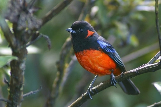
The Abra Malaga is a mountain pass that lies between the town of Ollantaytambo and Quillabamba, through unique Andean ecosystems. This path contains two types of well-defined areas: The Abra (4,297 m) and the lower part (Carrizales 3,245 m). The birds that you’ll observe are rare and highly sought after.
In Santa Teresa there are thermal baths: Cocalmayo, composed of 3 pools of different sizes, temperatures and depth. You can also do adventure sports like rafting, kayaking and zip line
Machu Picchu is one of the 7 Wonders of the Modern World, Heritage of Humanity, Historical Sanctuary of Peru and probably the most important archaeological site in Latin America.
Machu Picchu is majestic architecture comprises 140 structures throughout the citadel.
Machu Picchu is was built by the Inca Pachacutec around the year 1460
After being forgotten, it was only in 1911 that the American Hiram Bingham reached Machu Picchu on an expedition and spread the site worldwide.
Brief Itinerary
- DAY 1: CUSCO – ABRA MALAGA - SANTA MARIA (BIKING) - DAY 2: SANTA MARIA – SANTA TERESA (TREKKING) - DAY 3: SANTA TERESA - AGUAS CALIENTES (TREKKING) - DAY 4: MACHU PICCHU - CUSCO UNFORMATION OF INCA JUNGLE
The Abra Malaga is a route that starts in the town of Ollantaytambo, Cusco and runs along the 28B Ollantaytambo - Quillabamba road through unique Andean ecosystems. This route contains two types of well-defined areas: El Abra (4,297 meters above sea level) and the lower zone (Carrizales 3,245 meters above sea level). The birds you can see are rare and highly sought after. The predominant ecosystem is the rain forest Montano Tropical or cloud forest in the Carrizales area, with low-rise tree forests covered by epiphytic plants and also some bamboo areas. In the Abra Málaga, at 4,200 meters high, we are in a tropical rainforest-Montano moor, with small Polylepis forests at the basin births.
History
The birdlife in this area of Peru
was studied since 1869 by Sclater and Salvin, Berlepsch and Stolzmann (1906).
In 1915 an expedition of the Geographical Society Machu Picchu is made, directed by Frank M. Chapman and George K. Cherrie (July 1-24, 1916), and by Harry L. Watkins (April 3-25, 1917).
From September 1974, June 1976, 1977 and 1978, October 1978 and August 1979, personnel from the Zoological Museum of Louisiana State University (LSU) visited the valley to conduct an inventory and increase knowledge of birds and small mammals. Three main camps were made along the Ollantaytambo-Quillabamba road through the Abra Málaga (3900 m), and a fourth was in Kiteni (450 m), after Quillabamba.
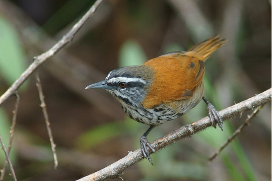
Starting from Ollantaytambo, the first place to visit is Las Peñas, located 15 Kms from the town. Named for having remains of Inca stone constructions in place. In the surroundings, between the bushes and at the edge of the road you can see: Cuzco Brush-finch, Chestnut-breasted Mountain-finch, Tyrian Metaltail, Shining Sunbeam, White-tufted Sunbeam, Puna Tapaculo, White-browed Conebill.
Another place of interest is the descent of the Abra, on the way to Quillabamba, where the good places are the Vegetation patches around the track, there you can see the Puna Thistletail, Unstreaked Tit-tyrant, Creamy-crested Spinetail, Diademed Tapaculo, Thrush- like Wren, Rufous-chested Tanager, Buff-breasted Mountain-tanager, Chestnut-bellied Mountain-tanager, Scarlet-bellied Mountain-tanager, White-bellied Hummingbird.
The Abra Málaga Thastayoc is the highest point of the route and is the safest and most accessible area to see the Royal Cinclodes. To do this you must follow the path that starts at the checkpoint, located at the highest point of the Abra. From there follow the path until you reach a Polylepis forest located at 4,150 meters high. You can also see the Stripe-headed Antpitta, Blue-mantled Thornbill, Shining Sunbeam, Puna Tapaculo, White-browed Tit-spinetail, Tawny Tit-Spinetail. The route for this forest is very rugged and long. It takes 2-3 hours to travel.
Weather
The weather is rainy between the months of November to April, and temperate with infrequent rains between the months of May to October. The temperature varies from -5 degrees in the Abra Málaga to 20 degrees in the Carrizales area.
Policies
Along the road it is not necessary to make any payment. To enter the Cinclodes route, it is necessary to pay an entrance fee, differentiated for Nationals and Foreigners. This payment is made at the checkpoint. Here you have bathrooms.
INFORMATION OF INCA JUNGLE