You can visit the architectural complex Choquequirao is situated in Vilcabamba at 3100 meters, considered the last Inka refuge and place of resistance from the invaders, when doing ....
Our Inca Jungle Trail classic To Machu Picchu combines adventure sports such as mountain biking, rafting, zip line, hot spring and trekking for 4 days until you reach Machu Picchu....
In the upper area close to the Skies, the Incas built one of their best-preserved cities, now recognized as one of the 7 wonders of the modern world. Many travelers and adventurers come....
According to the research, the coloration of the rainbow mountain is due to the composition of minerals that it has: the pink color is for the red clay, fangolitas and arilitas. The whitish, for the quartzose ...
Showing posts with label choquequirao trek to machu picchu. Show all posts
Showing posts with label choquequirao trek to machu picchu. Show all posts
What does Choquequirao mean? Choquequirao is a Quechua word that means 'Cradle of Gold'. The name comes from the nomination of a hill near the archaeological site. Where it is located? Choquequirao is located in one of the fringes of the snowy Salkantay, north of the Apurímac River. It is currently located in the Santa Teresa district, La Convencion province, Cusco department, Peru. How high is it?
Choquequirao is located 3,033 meters above sea level (m.s.n.m.). Due to its location, it is presumed that this Inca site served as a checkpoint between the main Inca sites such as Pisac, Cusco and Machu Picchu. What's in Choquequirao? Choquequirao has only been excavated by 30%. Despite this, it already has several very important Inca buildings:
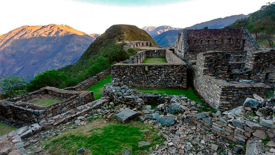
Main square - The main square or Huaqaypata divided the enclosure into two. It is a two-story stone construction. Along with this, there are other buildings connected to each other. Colcas - Typical constructions of the main Inca centers. In Choquequirao, these platforms have internal subdivisions. The purpose of these warehouses was to store products for food, clothing and others. Platforms - Choquequirao has a significant number of platforms for cultivation. In the western sector there are 22 engravings in the form of a flame arranged on 15 platforms. These figures are known as the 'Flames of the Sun'. Housing - In the highest part of Choquequirao, there are up to 5 buildings whose purpose was probably housing for the priests of the compound. This Inca site is believed to have been an important ceremonial center. Inca Cemetery - Also known as the 'Triumphal Wall'. There were found 17 funeral bundles and a water trough called "The House of the Fall of Water". Kallankas - These rectangular buildings had multiple functions such as workshop, administrative center, meeting space, etc. In Choquequirao there are 2 Kallankas on whose walls there were gutters that supplied water. Ushnu - This oval platform construction sits on top of a hill. Due to the wall that surrounds it and the privileged view of the snow-capped mountains, the river and the entire enclosure; it is believed to have had a religious purpose.
Day 1: CUSCO - CACHORA - COCAMASANA - PLAYA ROSALINA.
We will pick you up at your hotel in a private bus. We start from Cusco, then we go to the town of Cachora (3100 masl), here we find the carriers and support staff, in Cachora we’ll start our walk, after 2 hours of walking we reach Capuliyoc (2915 m) from there we’ll have a beautiful view of the snowy peaks Padrayoc, Wayna Cachora and the Apurimac valley. Then we’ll descend toward Coca Masana (2330m) where the climate becomes warmer and the flora and fauna begin to change. Finally we reach the Rosalina beach (1550m) located on the bank of the Apurimac River where we will have dinner and spend the night.
- Meals: Lunch, Dinner - Acomodación: Camp, Playa Rosalina 1550 msnm - Climate : warm and sunny - Distance Travelled: Approximately 12km - Hiking time : 6 hour
Day 2: PLAYA ROSALINA – CHOQUEQUIRAO.
This day is the hardest of the five days, we will get up very early. After breakfast, we begin our trek by a steep road for about 5 hours until we reach Raqaypata where we will have lunch. Throughout the walk we will observe many orchids and wild flowers, many birds. From Raqaypata we’ll walk for about two hours to the archaeological site of Choquequirao and there we will observe the sunset and the flight of the condor. Our campsite will be installed outside the ruins.
- Meals: Breakfast, Lunch, Dinner - Acomodación: Camp, Choquekiraw 3100 msnm - Climate : warm and cold at night - Distance Travelled: Approximately 14km - Hiking time : 7 hour
Day 3: CHOQUEQUIRAO - PINCHINUYOC
After breakfast. We dedicate this mornig to explore the ruins of Choquequirao, and have a little rest before lunch. In the afternoon we begin our trek by a steep road for about 2 hours until we reach Pinchinuyoc where we will camp for the night. This is definitely the easiest day of the trip
- Meals: Breakfast, Lunch, Dinner - Acomodación: Camp, Pinchinuyoc 2100msnm. - Climate : warm, windy and cold at night - Distance Travelled: Approximately 12km - Hiking time : 8 hour
Day 4: PINCHINUYOC – RIO BLANCO - MAIZAL.
After breakfast, we will hike down hill for 2 hours and arrive at the canyon of the Rio Blanco (1990 m / 6527 feet), where you can dip your feet in the cool waters. where we have a rest before starting a difficult climb to our campsite of Maizal (2100 m / 6889 f.) The climb is 3- 4 hours long. Este es probablemente el día más difícil del viaje, pero si se ha preparado bien y está decidido, tendrá éxito. Y la cerveza fría a su llegada sabrá aún mejor.
- Meals: Breakfast, Lunch, Dinner - Climate : warm and hummed - Acomodación: Camp, Maizal 2100 msnm. - Distance Travelled: Approximately 17km - Hiking time : 8 hour
Day 5: MAIZAL - YANAMA - DRIVE TO LUCMABAMBA
After our breakfast, we will begin our trek of about 3 hours approximately until we reach the old Victoria mine, then we will walk uphill until we reach Victoria pass (4130mt / 13,546 ft). There are spectacular views from the pass as we descend to the charming village of Yanama (about 2 hours walk) following a section with some well constructed inca trail. here we take the local transport all the way to Lucmabamba. Along the way, we get to enjoy the gorgeous views of snow-capped mountains and wáterfalls.
- Meals: Breakfast, Lunch, Dinner - Climate : cold and windy - Acomodación: Camp, Lucmabamba 1900msnm. - Distance Travelled: Approximately 20 km - Hiking time : 9 hour
Day 6: LUCMABAMBA - LLACTAPATA - AGUAS CALIENTES
Your final day of hiking: On this day we well hike for 3 hours by a Inca trail spectacular up through lush coffee and tropical fruit plantations, into pristine cloud forest, until reaching the Inca remains of Llactapata (2,700 m / 8,907 ft). The view across of Machu Picchu is magnificent. Few tourists have ever seen it from this side. Then we hike downhill for 2 hours to the hydroelectric plant where we have lunch. From here you have two choice. Either wait for the short but spectacular train ride (no included), or hike two to three hours along the rail track to the tourist town of Machu Picchu Pueblo and your hostel for the night.
- Meals: Breakfast, Lunch, Dinner - Climate : cold - Acomodación: Hostel, Aguas Calientes 1650msnm. - Distance Travelled: Approximately 9 km - Hiking time : 4 hour
Day 7: MACHU PICCHU - CUSCO
After an early breakfast at the hotel, we walk uphill to Machu Picchu at 5:00 am. or take the bus from Aguas Calientes to Machu Picchu (Optional bus $16 each way), upon arrival at the Citadel we can appreciate the enigmatic beauty and the incomparable example of architectural perfection and hydraulics of one of the 7 Wonders of the Modern World, we will have a guided tour of about 2 hours, where we can appreciate the Main Plaza, the Circular Tower, Intihuatana, The Royal Quarters, the Temple of the Three Windows and the Cemetery, you are then given free time to stroll around the citadel . You will have all morning in Machu Picchu to take pictures, maybe to climb the Wayna Picchu or Machu Picchu Mountain, enjoy this mystical place. Then we´ll descend by bus to Aguas Calientes for lunch and then calmly return by train to Ollantaytambo where our tourist transport to the city of Cusco will be expecting us, and will later transfer you to your hotel. OTHER ACTIVITIES: Climb up Huayna Picchu and appreciate the beauty and magnificence of Machu Picchu from there (We recommend that you book in advance) Not Included Climb Machu Picchu Mountain and appreciate the beauty and magnificence of Machu Picchu from there (We recommend that you book in advance) Not Included Visit the new local museum or the hot springs in Aguas Calientes later in the day. Not Included
- Meals: Breakfast - Tour: 2 hour guided tour of Machu Picchu
Day 1: CUSCO - CACHORA - COCAMASANA - PLAYA ROSALINA.
We will pick you up at your hotel in a private bus. We start from Cusco, then we go to the town of Cachora (3100 masl), here we find the carriers and support staff, in Cachora we’ll start our walk, after 2 hours of walking we reach Capuliyoc (2915 m) from there we’ll have a beautiful view of the snowy peaks Padrayoc, Wayna Cachora and the Apurimac valley. Then we’ll descend toward Coca Masana (2330m) where the climate becomes warmer and the flora and fauna begin to change. Finally we reach the Rosalina beach (1550m) located on the bank of the Apurimac River where we will have dinner and spend the night.
- Meals: Lunch, Dinner - Acomodación: Camp, Playa Rosalina 1550 msnm - Climate : warm and sunny - Distance Travelled: Approximately 12km - Hiking time : 6 hour
Day 2: PLAYA ROSALINA – CHOQUEQUIRAO.
This day is the hardest of the five days, we will get up very early. After breakfast, we begin our trek by a steep road for about 5 hours until we reach Raqaypata where we will have lunch. Throughout the walk we will observe many orchids and wild flowers, many birds. From Raqaypata we’ll walk for about two hours to the archaeological site of Choquequirao and there we will observe the sunset and the flight of the condor. Our campsite will be installed outside the ruins.
- Meals: Breakfast, Lunch, Dinner - Acomodación: Camp, Choquekiraw 3100 msnm - Climate : warm and cold at night - Distance Travelled: Approximately 14km - Hiking time : 7 hour
Day 3: CHOQUEQUIRAO - MAIZAL
After breakfast. We dedicate this mornig to explore the Choquequirao, and then start our trek passing for Choquequirao Ruins, uphill through cloud forest, Mountains and valleys to reach the Choquequirao pass. There will observe different species of birds, different varieties of orchids, and local coca plantations. then we will continue our trek until we reach the Blanco river where we will have lunch and you can dip your feet in the cool waters, we have a rest before starting a difficult climb to our campsite of Maizal (3000 m / 9842 f.) The climb is 3- 4 hours long.
- Meals: Breakfast, Lunch, Dinner - Acomodación: Camp, Maizal 3000msnm. - Climate : warm, windy and cold at night - Distance Travelled: Approximately 18km - Hiking time : 8 hour
Day 4: MAIZAL - YANAMA.
Due to the ecosystem’s constant changes, this day is both the most ardous and the most spectacular one. After breakfast, we will begin our walk where you can enjoy the view of the beautiful landscape. Since the Inca trail in this region is not in good conditions during the rainy season, we ask you to watch your steps carefully. In San Juan (4170m/13681f) we will enjoy the beautiful view of the valleys, the mountains and the glaciers, from which some of the latter peak more than 5000m/16404f. Our camping place will be in the little village of Yanama (3530m/11581f).
- Meals: Breakfast, Lunch, Dinner - Climate : warm and hummed - Acomodación: Camp, Yanama 3530 msnm. - Distance Travelled: Approximately 17km - Hiking time : 8 hour
Day 5: YANAMA - TOTORA
Early in the morning, we will head for the highest pass of this trip - Yanama (4670m). If we are lucky we will even see a condor flying. During the day, we will enjoy frequently the view of snow capped mountains such as Salkantay (6264m) and Pintuyu (5450m). Our camping place will be in the valley of Totora pampa (3100m).
- Meals: Breakfast, Lunch, Dinner - Climate : cold and windy - Acomodación: Camp, Totora 3100 msnm. - Distance Travelled: Approximately 20 km - Hiking time : 9 hour
Day 6: TOTORA - PLAYA - SANTA TERESA
At Totora pampa we will get the chance to meet Quechua-speaking Andean people who live from agriculture and cattle breeding. The vegetation on our way gets more and more bizarre and reveals its diversity of orchids, bromelains and other plants. We will also see some plantations for coffee, papaya, passion fruit and avocado. Our camping site will be in La Playa (2100m/6890f) or in Santa Teres (1600m/5249f). Note: According to the group’s whishes, it is possible to change the itinerary a bit and visit the hot springs in Santa Teresa this day.
- Meals: Breakfast, - Climate : warm - Acomodación: Camp, Santa Teresa 1600msnm. - Distance Travelled: Approximately 18 km - Hiking time : 10 hour
Day 7: SANTA TERESA - AGUAS CALIENTES
The last breakfast with our crew, after drive to hydroelectric 40 min where is the start point for hike to Aguas Calientes 3 hours, on the trail is clear to appreciate a lot type of orchid and birds, the big scenery is the view to Machu Picchu city is situated dense a bizarre vegetation and offers an exceptional view of the mountain Machu Picchu, for sick or tired kickers optional train service (US $ 18.00) there we will spend the night in a hotel in Aguas Calientes.
- Meals: Breakfast, Lunch, Dinner - Climate : warm - Acomodación: Hostel, Aguas Calientes 2050msnm. - Distance Travelled: Approximately 9 km - Hiking time : 4 hour
Day 8: MACHU PICCHU - CUSCO
After an early breakfast at the hotel, we walk uphill to Machu Picchu at 5:00 am. or take the bus from Aguas Calientes to Machu Picchu (Optional bus $16 each way), upon arrival at the Citadel we can appreciate the enigmatic beauty and the incomparable example of architectural perfection and hydraulics of one of the 7 Wonders of the Modern World, we will have a guided tour of about 2 hours, where we can appreciate the Main Plaza, the Circular Tower, Intihuatana, The Royal Quarters, the Temple of the Three Windows and the Cemetery, you are then given free time to stroll around the citadel . You will have all morning in Machu Picchu to take pictures, maybe to climb the Wayna Picchu or Machu Picchu Mountain, enjoy this mystical place. Then we´ll descend by bus to Aguas Calientes for lunch and then calmly return by train to Ollantaytambo where our tourist transport to the city of Cusco will be expecting us, and will later transfer you to your hotel. OTHER ACTIVITIES: Climb up Huayna Picchu and appreciate the beauty and magnificence of Machu Picchu from there (We recommend that you book in advance) Not Included Climb Machu Picchu Mountain and appreciate the beauty and magnificence of Machu Picchu from there (We recommend that you book in advance) Not Included Visit the new local museum or the hot springs in Aguas Calientes later in the day. Not Included
- Meals: Breakfast - Tour: 2 hour guided tour of Machu Picchu
Choquequirao known as the sacred sister of Machu Picchu because it has a structural and architectural similarity, archaeological monuments are made up of terraces distributed on different levels which were leveled and fenced with stones to form a platform with an approximate area of 150 square meters. CHOQUEQUIRAO TREK INFORMATION
Location
The Choquequirao ruins are located at 13 ° 32 ’latitude and 77 ° 44’ west longitude, it is located at 3033 masl in the mountains of the snowy Salkantay north of the Apurímac river in the district of Santa Teresa province of the department of Cusco.
How to get
Currently to reach the last Inca fortress is the land route, the best known route of how to get to Choquequirao is by taking the road to Abancay, and at km 154 choose the detour that will direct you to the town of Cachora.
The route to Choquequirao has narrow paths which must be walked very carefully, also have a good physical condition and the proper equipment for this trek.
Weather
Due to its height, Choquequirao enjoys a temperate climate. However, it should be noted that the Choquequirao path is warm due to the Apurímac canyon.
Description
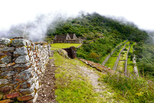
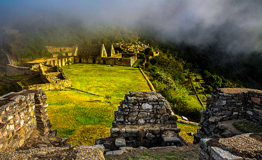
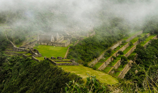
Choquequirao (comes from the Aymara words chuqui, gold, and from Quechua k'iraw, cradle, that is to say: "cradle of gold"), is another of the archaeological zones also known as the Inca citadel, it is located between the ramifications of the Nevado de Salcantay, southern Peru. These archaeological remains of Choquequirao are made up of a set of buildings and terraces distributed on different levels, from the lower Sunch'u Pata level to the highest truncated summit, which was leveled and fenced with stones to form a platform with an area approximately 150 square meters.
Choquequirao (sometimes also referred to as Choqequirau or Choquekiraw), is also known as the "sacred sister" of Machu Picchu for the structural and architectural similarities presented with it. Well, not too long ago it became known about this majestic place, thus awakening the interest of many tourists and researchers.
Biodiversity
The environment of Choquequirao is one of the richest in biodiversity, biologists, ecologists and experts mention this, however in this area, the number of species of plants and animals that exist is not known exactly, despite this deficiency and From the few scientific studies carried out, it has been possible to determine the existence of various life forms.
Among the most relevant species are: the condor, the fox, the skunk, the puma, the spectacled bear, the taruca, the vizcachas, the pica pica, the tall toucan, the quetzales and the tigrillos. All these species have been conditioned despite the temperature variations such as the sun throughout the day and the inclement frosts at night. This space can also be seen to the cock of the rocks, Peru's national bird.
The flora of the place is made up of giant ferns and a great variety of orchids, where the wakanki variety stands out. At the bottom of the great valley and under the thermal effect of the water course that runs through it, the forests of the mountain eyebrow provide their warmth and ideal conditions for a huge variety of crops of coca, annatto, corn, cocoa, coffee and fruit trees.
From the environmental point of view, the main value of these presented ecosystems resides in the role played by the exuberant forests that grow in the high parts of the mountains for the maintenance of the water balance of the region, capturing the rainwater and leading it without causing erosion towards the Apurimac River. MORE INFORMATION OF CHOQUEQUIRAO TREK TO MACHU PICCHU
CHOQUEQUIRAO es un lugar tan maravilloso como Machu Picchu; menos conocido, más inexplorado. Virgen y libre de la abundante visita turística. Un Machu Picchu para llegar como mochilero, con largas caminatas independientes y acampadas en la ruta. Choquequirao es también conocida como la hermana sagrada de Machu Picchu. Se trata pues de un gran complejo arqueológico con edificios y terrazas, testimonio de los Incas conquistando las alturas de las montañas.
En esta guía aprenderás cómo llegar por tu cuenta a este santuario. Aprovecha los recursos de Cusco destination para descubrir una de las ruinas más impresionantes de Latinoamérica.
Antes debes saber un par de cosas:
¿Por qué si es tan increíble va tan poca gente o se sabe poco de él?
A diferencia de Machu Picchu a donde se puede llegar con trenes y ascender en buses, Choquequirao es un destino al que se llega a través de un intenso sacrificio y esfuerzo. Son caminatas duras que implican bajadas y desniveles con poco oxígeno. La manera de llegar es caminando mucho y acampando. Posiblemente tu abastecimiento de agua no sea suficiente, pases frío en las alturas o bien te quemes caminando bajo el intenso sol andino. El viaje completo puede hacerse entre 4 y 5 días salvo que quieras visitar algunos pueblos aledaños o hacerlo rápidamente.
¿Cuánto se camina hasta Choquequirao?
Desde el poblado de Cachora hasta Choquequirao se caminan alrededor de 31 kilómetros sin incluir el recorrido por las ruinas. De regreso sería la misma distancia (62 km en total). Una gran parte del recorrido implica la bajada de una gran montaña mientras que la otra mitad es en una subida.
¿Aqué altura está Choquequirao?
La ciudadela se encuentra a 3,035 m.s.n.m y en el punto más bajo de la caminata estarás a 1,461 m.s.n.m. El clima es similar al de Cusco por lo que es recomendable acondicionarte a las alturas antes de la caminata.
Machu Picchu without hesitation is considered as the tourist icon of Peru, and of the more than 3 million tourists who visit us a year, more than 98% have a look at Meet Machu Picchu. However, in Peru there are places that can also be considered a tourist icon of Peru, but due to the little marketing they are given, it does not become known as Machu Picchu is now. informacion de Choquequirao Trek.
CHOQUEQUIRAO: Considered by many tourists who visited it like the other Machu Picchu and sometimes many tourists dare to say that it is better than Machu Picchu. The best thing about this archeological center is that it can only be accessed by walking as it does not exist, railways or roads that can take you to or near Choquequirao, so it is done full trekking many tourists consider this crossing as a Pilgrimage, an escape from the routine, an own challenge, escape from the bustle of the city, and being not well known sometimes the route is empty (without tourists) and on other occasions one can run into some tourists and these are few . Of course, sometimes the route can be full of tourists (nationals, school promotions and foreign tourists.). But almost the whole year the route is with few tourists. Choquequirao tour or trek: being a not very well-known or popular route, it is difficult to gather groups, so most of the time it is operated only in private service, thus raising operating costs. As an example, only the transportation service from Cusco in a minivan to Cachora, which is a starting point, costs around 300 to 400 dollars per way and another one equal to return. To this cost must be added the fees of the guide, Cook, freight forwards, fee of the person in charge of the commonly known as arriero, also the costs of food, tents, gas, agency fee, taxes, etc. All these costs make an organized excursion from Cusco to Choquequirao very expensive, and this causes many tourists to be discouraged from doing so and looking for other options or trying to do it on their own.
This is a spectacular hike through the Andes of Peru. You can visit the architectural complex of Choquequirao, which is situated in Vilcabamba at 3100 meters, and is considered the last Inka refuge and place of resistance from the invaders. When doing this trek you will enjoy hiking in beautiful scenery, you'll see the impressive Apurimac Canyon, you’ll see flora and wildlife in the path. This route offers a strenuous but formidable journey due to the various existing ecosystems. Information of Choquequirao Trek
Useful Information
- Starting Altitude - 2900m / 9515ft. - Highest Altitude - 3050m / 10,005ft - Walking Distance - 64 km / 40 miles - Longest Day - Day 1, approximately 25 km/15.5 miles - Overall Difficulty - Difficult
IMPORTANT INFORMATION:
Because of its altitude, Choquequirao has a temperate climate. However, it should be noted that the road to Choquequirao is warm because of the Apurimac canyon. Choquequirao was presumably used as a control site to ensure access to areas of Vilcabamba, connecting the jungle with other major centers like Pisac and Machu Picchu. The archaeological remains of Choquequirao are comprised of buildings and terraces on different levels, in which their terraces stand out due to 22 carvings on stone with figures known as "Llamas del Sol" arranged in 15 platforms towards the snowy Qori Hauyrachina. Choquequirao features a large system of platforms/terraces.
Brief Itinerary - Day 1: Cusco – Cachora – Chiquiska. - Day 2: Chiquiska – Choquequirao. - Day 3: Choquequirao - Day 4: Choquequirao – Coca Masana. - Day 5: Coca Masana - Cachora – Cusco.
CHOQUEQUIRAO TREK
You can visit the architectural complex Choquequirao is situated in Vilcabamba at 3100 meters, considered the last Inka refuge and place of resistance from the invaders, when doing this trek you will enjoy beautiful scenery, you'll see the impressive Apurimac Canyon, flora and wildlife along the path. This route offers a strenuous but formidable journey due to the various existing ecosystems.
Useful Information
- Starting Altitude - 2900m / 9515ft. - Highest Altitude - 3050m / 10,005ft - Walking Distance - 64 km / 40 miles - Longest Day - Day 1, approximately 25 km/15.5 miles - Overall Difficulty - Difficult
INCA JUNGLE TO MACHU PICCHU
Our Inca Jungle Trail classic To Machu Picchu combines adventure sports such as mountain biking, rafting, zip line, hot spring and trekking for 4 days until you reach Machu Picchu and one of the additional mountains "Machu Picchu Mountain" or "Huaynapicchu". The Inca Jungle route is the favorite tour for young people from all over the world who come to Cusco in search of deferent adventures and extreme sports. As a Tourism Agency located in Cusco we offer a differentiated service; with an exclusive route, trained guides (real command of English, local history and adventure sports), bicycles equipped for downhill, the safest rafting and zipline services. We recommend our passengers book in advance to have everything insured and avoid unnecessary risks such as loss of equipment, lack of access to Machu Picchu, Machu Picchu Mountain, Huayna Picchu or even worse, being stranded in Aguas Calientes (no return train). This tour is one of the classic routes full of adrenaline to the Inca citadel of Machu Picchu.
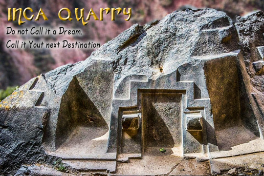
INCA QAURRY TREK TO MACHU PICCHU
The quarry of Cachicata was the place of extraction of the stones that were used for the construction of Ollantaytambo and many surrounding areas. This place is 9 kilometers from the Inca town of Ollantaytambo and has three groups of quarries: Molle Pucro, Sirkusirkuyoc (it was the largest), shows evidence of having been in full operation when the Spaniards entered this area. And finally Kantirayoq or Cacchicata, where another type of extraction of minerals and precious stones was practiced.
Useful Information
- Starting Altitude - 3350 meters / 10990 feet . - Highest Altitude - 4500m / 14,764ft - Walking Distance - 25 km / 15.5 miles - Meals - 2 breakfast, 2 lunch, 2 dinner, 2 tea times, 2 wake up tea - Overall Difficulty - Moderate - STARTING POINT: - Cusco at your hotel