This route offers a unique experience, an tourism route that gives us an unforgettable experience in the heights of the Sacred Valley. In the Lares Valley besides enjoying beautiful scenery you can enjoy a beautiful experience living with the local people, who will receive us with open arms showing the most beautiful thing about this place ... its "simplicity". On this route you can also enjoy the medicinal thermal baths, appreciate andean lagoons, snow-covered mountain passes and finally visit the Inca citadel of
Machu Picchu.
This alternative trek is one of the best opportunities to see the Mountain range of Urubamba, interact with the communities living in this area, walk around the woods of Queuñas and relax in the famous thermal baths of the town of Lares, as a good way to recharge batteries. To finish the tour we will visit the Inca citadel of Machu Picchu.
Useful Information
- Starting Altitude - 2900m / 11151ft.
- Highest Altitude - 4780m / 15,682 ft
- Walking Distance - 34 km / 21 miles
- Longest Day - Day 1, approximately 14km / 8.7 miles
- Overall Difficulty - Moderate - Difficult
IMPORTANT INFORMATION:
In the thermal baths of Lares there are 6 large swimming pools at different temperatures between 36 and 44 °C, you can choose to relax quietly, they are ideal for treating bone and gastrointestinal diseases.
Lares is surrounded by a mountain range that includes the Nevado Veronica (5900m high), the Sawasiray (5700m high), the Pitusiray and Chicon (5500m high). Small communities of Quechua-speaking farmers inhabit this recently-explored territory, who preserve their customs of herding llamas and alpacas, potato cultivation and textile production.
The recommended dates for traveling are the months from April to November with no rain in these months the climate is sunny, with a blue sky all day.
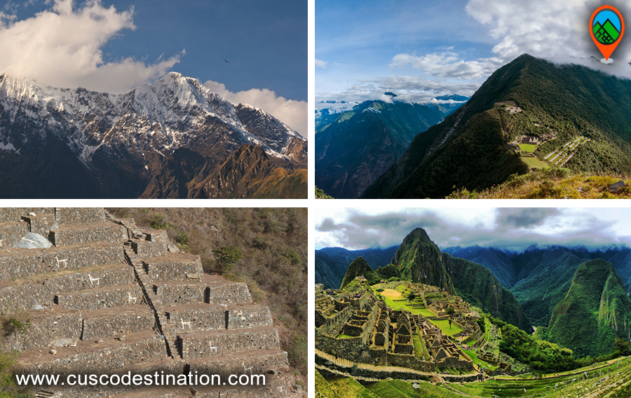
Machu Picchu is one of the 7 Wonders of the Modern World, Heritage of Humanity, Historical Sanctuary of Peru and probably the most important archaeological site in Latin America.
Machu Picchu is majestic architecture comprises 140 structures throughout the citadel.
Machu Picchu is was built by the Inca Pachacutec around the year 1460
After being forgotten, it was only in 1911 that the American Hiram Bingham reached Machu Picchu on an expedition and spread the site worldwide.
Brief Itinerary
- DAY 1: CUSCO – LARES HOT SPRINGS – CUNCANI
- DAY 2: CUNCANI – QUISWARANI- COCHAPATA LAKE
- DAY 3: COCHAPATA LAKE – PACHACUTEC PASS – CANCHACANCHA
- DAY 4: CANCHACANCHA – HUARAN – OLLANTAYTAMBO - AGUAS CALIENTES
- DAY 5: MACHU PICCHU -
CUSCO